13 JAMES STREET
ROTHERHAM, SOUTH YORKSHIRE S60 1JU
£50,000
Listing type
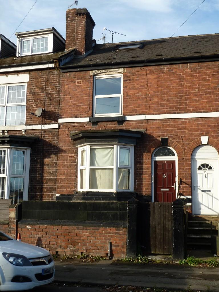
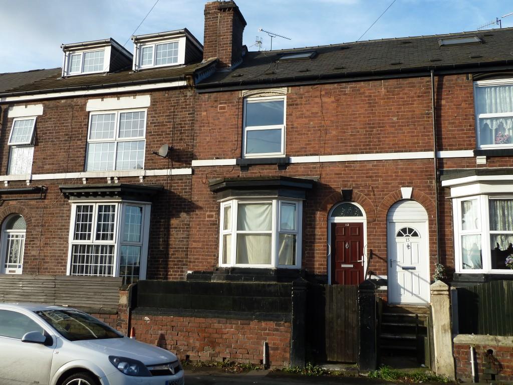
Photo 1 Photo 2
/ 2
Property details
Listing category
Auction
Floor area
113 m²
EPC rating
E
Year built
England and Wales: 1900-1929
Last sold
£81,000 Feb 2014
Price per m²
£442/m²
Local average
£170,833 (-70.7%)
Deprivation
Decile 1 (274 of 33,755)
Street crime
475 incidents within 1 mile (Apr 2026)
Key features
- FOR SALE BY AUCTION on TUESDAY 28 JANUARY 2014
- Spacious bay windowed inner terrace
- Modern gas fired central heating
- uPVC replacement windows
- Replacement roof covering
- Modern kitchen and bathroom fittings
- Requires general improvement
- Potential for owner occupation or investment
Additional details
- Garden
- Yes
Description
Ground Floor
Reception Hall
Sitting Room 4.48 m x 3.58 m
Dining Room 4.57 m x 3.79 m
Cellar Head
Kitchen 2.96 m x 2.29 m with a range of modern units
Basement
Cellar
First Floor
Landing
Front Bedroom One 4.57 m x 3.80 m with closet
Rear Bedroom Two 3.40 m x 3.01 m with closet
Bathroom / WC 2.99 m x 2.39 m with white suite, shower and airing cupboard
Second Floor
Attic Bedroom 4.56 m x 4.15 m with closet
Outside
Raised forecourt
Rear yard and raised decked area
EPC Rating D
The full Energy Performance Certificate is available via our website
VIEWING: Tuesday 7th, 14th & 21st January at 12.30pm prompt
Thursday 9th,16th & 23rd January at 12.30pm prompt
Listed by
Sheffield
Mark Jenkinson and son
Reference: 42135619
EPC Rating & Upgrade Cost
Current rating: E
Potential rating: C
Inspection date: 10/05/2015
Current heating cost: £1,214/year
Potential heating cost: £708/year
Est. upgrade cost to C: £23,655
Recommendations
- Room-in-roof insulation (£1,500 - £2,700)
- 50 mm internal or external wall insulation (£4,000 - £14,000)
- Floor insulation (suspended floor) (£800 - £1,200)
- Low energy lighting for all fixed outlets (£55)
- Solar water heating (£4,000 - £6,000)
- Solar photovoltaic panels, 2.5 kWp (£5,000 - £8,000)
Flood risk
Zone: 1
Risk: Low
Job (default Low)
Price history
| Event | Date | Price | % change |
|---|---|---|---|
| Sold | 25/02/2014 (12 years ago) | £81,000 | — |
Source: HM Land Registry Price Paid Data. Crown copyright.
Sold Comparables
Same street and nearby sales within 0.25 miles (last 5 years). Data from Land Registry Price Paid.
| Address | Price | Date | Type |
|---|---|---|---|
| 7 WALTER STREET, ROTHERHAM, SOUTH YORKSHIRE, S60 1LL | £65,000 | 23/01/2026 | Terraced |
| 36 WALTER STREET, ROTHERHAM, SOUTH YORKSHIRE, S60 1LL | £78,000 | 15/12/2023 | Terraced |
| 16 ST JOHNS AVENUE, ROTHERHAM, SOUTH YORKSHIRE, S60 1HZ | £75,000 | 24/07/2023 | Terraced |
| 88 CLOUGH STREET, ROTHERHAM, SOUTH YORKSHIRE, S61 1RJ | £70,000 | 23/06/2023 | Terraced |
| 42 ST JOHNS AVENUE, ROTHERHAM, SOUTH YORKSHIRE, S60 1HZ | £39,000 | 28/03/2023 | Terraced |
| 141 JAMES STREET, ROTHERHAM, SOUTH YORKSHIRE, S60 1JZ | £43,000 | 04/11/2022 | Terraced |
| 106 CLOUGH STREET, ROTHERHAM, SOUTH YORKSHIRE, S61 1RJ | £90,000 | 20/05/2022 | Terraced |
| Same street 12 JAMES STREET, ROTHERHAM, SOUTH YORKSHIRE, S60 1JU | £210,000 | 23/03/2022 | Semi-detached |
| 80 CLOUGH STREET, ROTHERHAM, SOUTH YORKSHIRE, S61 1RJ | £95,000 | 31/01/2022 | Terraced |
Street average: £210,000 (1 sale)
Area average: £69,375 (8 sales)
Capital growth trend
Land Registry outcode average: last 12 months vs 5y and 10y ago (from sold prices).
House Price Index (HM Land Registry — official index, not sold-price averages): Rotherham. Series: Terraced. As of March 2026.
Rental Range
Estimated market rent for Rotherham. Low = conservative, Realistic = average, Optimistic = best case.
Based on Local Authority from postcode lookup → Rotherham.
LHA (30th percentile) floor for Rotherham: £549/mo (Apr 2025 – Mar 2026)
Location
Nearby
Nearest stations, universities and amenities (distance from property).
| Type | Name | Distance |
|---|---|---|
| Bus stop | New Wortley Road/Brown Street | 0.1 miles |
| Shop | Masbrough Off Licence | 0.1 miles |
| Bus stop | New Wortley Road/James Street | 0.1 miles |
| Shop | Aldi | 0.2 miles |
| Train station | Rotherham Central | 0.3 miles |
| Hospital | Woodside Workplace Health & Wellbeing | 1.4 miles |
| Hospital | Badsley Moor Lane NHS | 1.5 miles |
| Train station | Meadowhall Interchange | 2.1 miles |
| University | The University of Sheffield AMRC | 3.2 miles |
| University | Sheffield Hallam University | 5.2 miles |
Street-level crime
| Category | Count |
|---|---|
| Violence and sexual offences | 131 |
| Shoplifting | 85 |
| Anti-social behaviour | 67 |
| Public order | 45 |
| Other theft | 33 |
| Criminal damage and arson | 24 |
| Robbery | 21 |
| Vehicle crime | 21 |
| Burglary | 20 |
| Other crime | 15 |
| Drugs | 8 |
| Bicycle theft | 2 |
| Possession of weapons | 2 |
| Theft from the person | 1 |
| Total incidents | 475 |
Within 1 mile during Apr 2026. Source: data.police.uk (England & Wales).
Schools nearby
Nearest open schools with Ofsted ratings (England). Closed schools are not shown. Data from Get Information about Schools and Ofsted.
| Name | Type | Distance | Ofsted |
|---|---|---|---|
| Thornhill Primary School | Primary | 0.2 miles | Good — 4 Dec 2022 |
| Ferham Primary School | Primary | 0.4 miles | Inadequate — 2 Jun 2020 |
| RNN Group | Other | 0.7 miles | — (No rating) |
| Kimberworth Community Primary School | Primary | 0.8 miles | Good — 27 Jun 2024 |
| St Ann's Primary School | Primary | 1.0 miles | Good — 8 Nov 2023 |
Rental Comparables
Rental listings exist nearby, but none matched the 3-bedroom count for this property.
Rent-driven metrics
Based on Area rent estimate.
- Rent ratio — Monthly rent ÷ purchase price (1% rule). 1%+ = strong, 0.8–1% = okay, <0.8% = weak for cashflow.
- Max investor price — Rent ÷ 0.8%; the price at which rent would be 0.8% of price (Stoke-style target).
- Target investor price — Rent ÷ 1%; the price at which rent would be 1% of price (strong cashflow band).
- Gross yield — Annual rent as % of purchase price (no costs).