Residential Development Land At Chester Road
Whitchurch, Shropshire., SY13 4QG
Property details
Tenure
FREEHOLD
Local average
£536,750 (+272.6%)
Deprivation
Decile 9 (29,228 of 33,755)
Street crime
43 incidents within 1 mile (Apr 2026)
Key features
- Outline Planning Permission for residential development (subject to S.106)
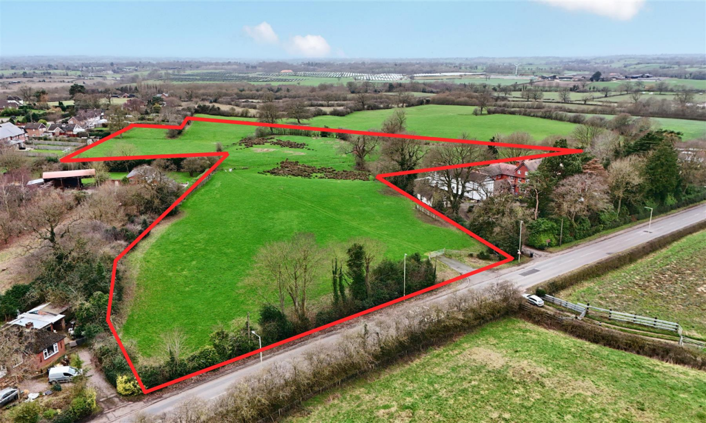
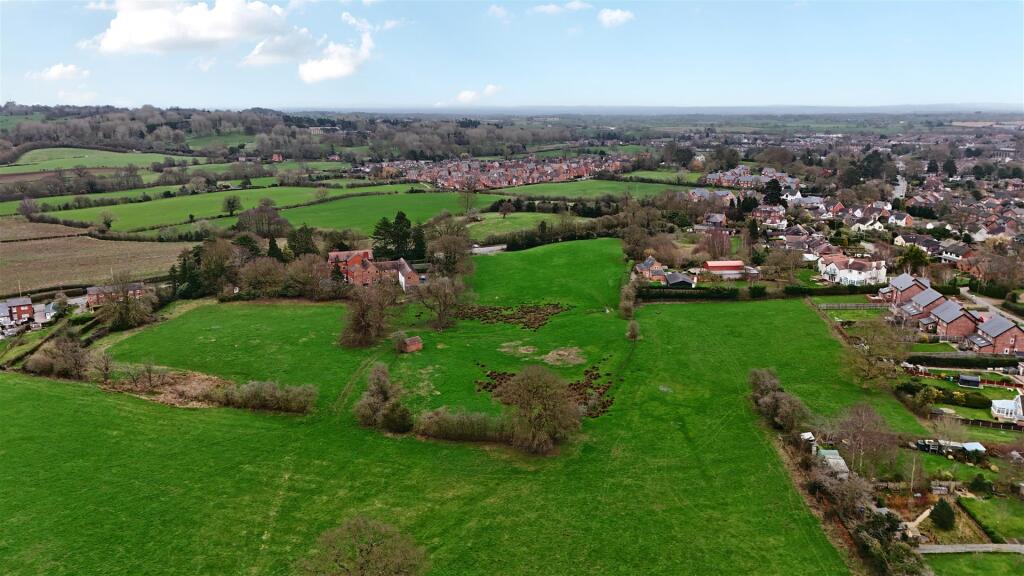
- Gross site extending to circa 8.2 acres (3.32 hectares)
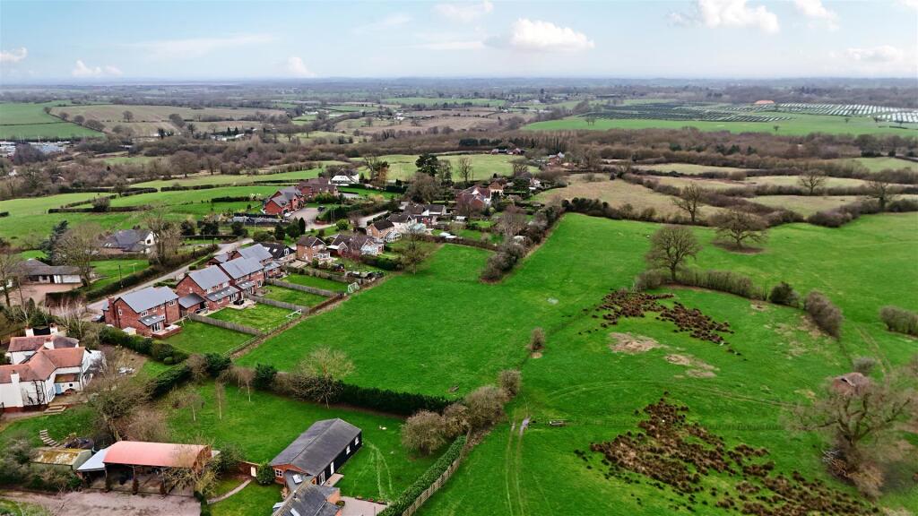
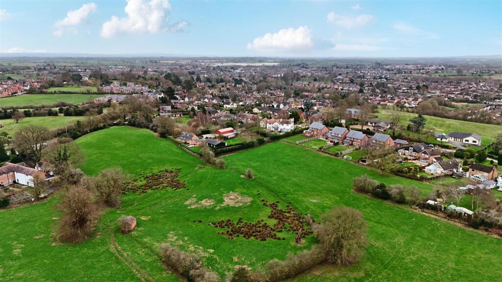
- Gently undulating agricultural land
- Located in a prime position on the edge of Whitchurch
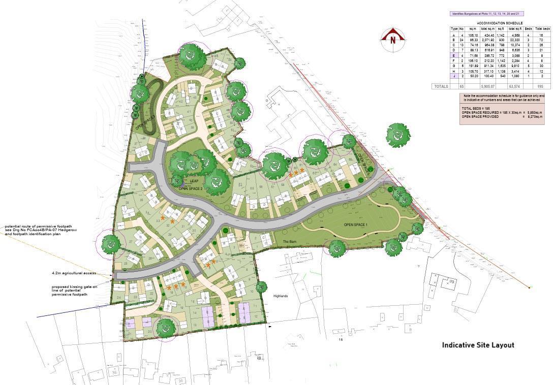
- Suitable for development of around 65 dwellings (this may be increased subject to planning permission being granted).
- Offers invited by Informal Tender, subject to contract, no later than 12 noon on Friday 10th of April 2026
Description
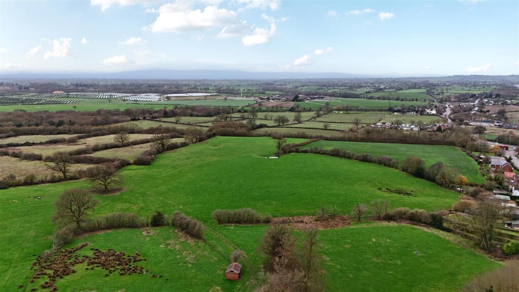
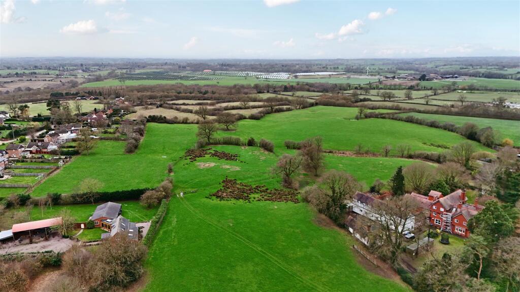
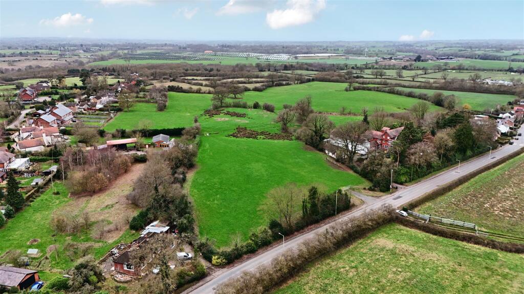
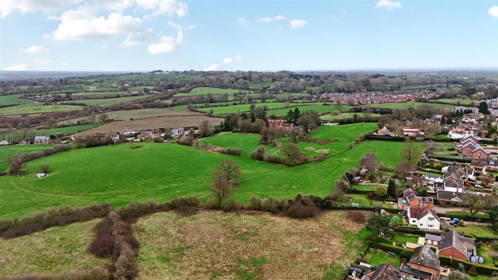
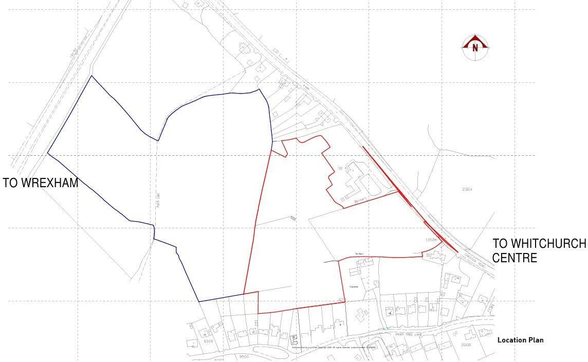
Description - The site has a gross area of circa 8.2 acres and has historically been used for agricultural purposes (grazing), with a gently undulating topography falling from south to north, directly accessed from Chester Road (B5395).
The land has Outline Planning Permission approved, subject to the completion of a Section 106 legal agreement, with an indicative site layout showing 65 dwellings. However, the site may be capable of accommodating a higher number of dwellings, subject to planning permission being granted.
The site is bounded to the south by residential properties on Pear Tree Lane, to the north by the former Cloverfield Nursing Home and further residential development, to the east by Chester Road and open countryside beyond, and to the west by agricultural land.
The location is regarded as one of the prime residential positions within Whitchurch and the completed development is expected to be highly sought after.
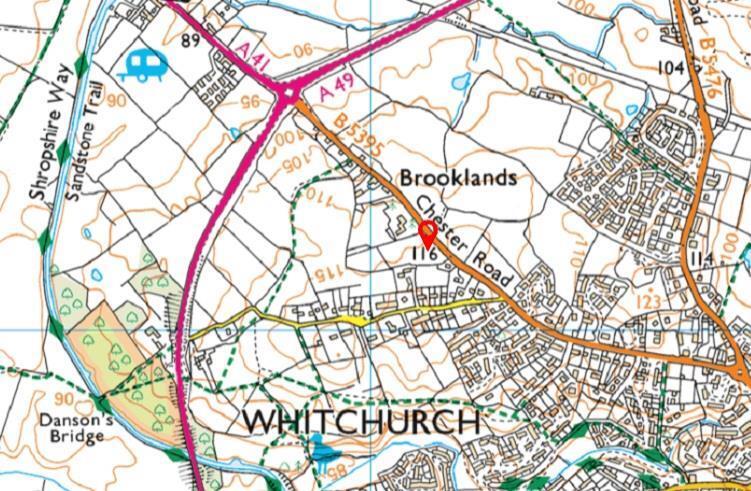
Location - The site is located on the north-western edge of Whitchurch, immediately west of Chester Road (B5395).
Whitchurch is a well-established North Shropshire market town offering a wide range of amenities including independent and national retailers, supermarkets, schools, medical facilities, cafés and public houses.
The town benefits from a mainline railway station with services to Crewe, Shrewsbury and Manchester, with onward connections to London. Road communications are excellent via the A41, providing access to Chester, the West Midlands and North Wales.
Planning - Planning Application Reference: 25/02878/OUT.
Outline Planning Permission is approved subject to the Section 106 agreement which will secure 15% affordable housing, biodiversity net gain for a minimum of 30 years, on-site public open space including a Local Equipped Area for Play (LEAP), a financial contribution towards the Whitchurch Local Cycling and Walking Infrastructure Plan (LCWIP)*, and long-term management of public open space and sustainable drainage systems (SuDS).
* A financial contribution of £260,000 (circa £4,000 per dwelling, based on the indicative layout) towards the Whitchurch Local Cycling and Walking Infrastructure Plan (LCWIP) has been cited.
Offers are therefore to be submitted on the assumption that this contribution will be payable. Should the contribution be reduced, amended or ultimately not required, the full value of such reduction will be added to the purchase price.
Tenure - The site is held freehold tenure predominantly under Land Registry Title Number SL150299.
Available Information - A full suite of information is available upon request from the selling agents.
Site Viewings - A general site viewing is available from a roadside inspection. For a detailed site walk-around, interested parties should contact the selling agents.
Future Land - There is a further circa 13 acres of agricultural land to the west of the site, to which access will be retained for potential future residential development.
Method Of Sale - The land is offered for sale by Informal Tender. Offers are to be submitted in writing by 12 noon on Friday 10th April 2026.
Offers should include the following:
-offer amount
-proof of funding
-any conditions attached
-proposed timescale for completion
-solicitors’ details.
All offers should be submitted for the attention of Mr J Quinn by email to or by recorded post to arrive no later than 12 noon on 10th April 2026.
Listed by
Ellesmere
Halls Holdings Ltd
Reference: 172604018
EPC Rating & Upgrade Cost
Fetching EPC data… Refresh this page in a moment.
Flood risk
Zone: 1
Risk: Low
Job (default Low)
Floorplans
Plan 1.jpg
Plan 2.jpg
Plan 3.jpg
Price history
| Event | Date | Price | % change |
|---|---|---|---|
| Listed for sale | — | £2,000,000 | — |
Source: HM Land Registry Price Paid Data. Crown copyright.
Sold Comparables
Same street and nearby sales within 0.25 miles (last 5 years). Data from Land Registry Price Paid.
| Address | Price | Date | Type |
|---|---|---|---|
| CLOVERFIELDS CHESTER ROAD, WHITCHURCH, SHROPSHIRE, SY13 4QG | £900,000 | 29/11/2021 | Other |
Area average: £900,000 (1 sale)
Capital growth trend
Land Registry outcode average: last 12 months vs 5y and 10y ago (from sold prices).
House Price Index (HM Land Registry — official index, not sold-price averages): Shropshire. Series: All dwelling types. As of March 2026.
Rental Range
Estimated market rent for Shropshire. Low = conservative, Realistic = average, Optimistic = best case.
Based on Local Authority from postcode lookup → Shropshire.
LHA (30th percentile) floor for Wigan: Apr 2025 – Mar 2026
Location
Address
Chester Road
Nearby
Nearest stations, universities and amenities (distance from property).
| Type | Name | Distance |
|---|---|---|
| Bus stop | Whitchurch, Chester Road / Pear Tree lane | 0.2 miles |
| Bus stop | Unknown | 0.5 miles |
| Shop | Argos | 0.6 miles |
| Shop | Aldi | 0.6 miles |
| Hospital | Whitchurch Community Hospital | 0.9 miles |
| Train station | Whitchurch | 1.2 miles |
| Train station | Prees | 5.3 miles |
| Hospital | Penley Hospital | 7.3 miles |
Street-level crime
| Category | Count |
|---|---|
| Violence and sexual offences | 20 |
| Criminal damage and arson | 6 |
| Shoplifting | 5 |
| Other crime | 3 |
| Other theft | 3 |
| Burglary | 2 |
| Public order | 2 |
| Drugs | 1 |
| Vehicle crime | 1 |
| Total incidents | 43 |
Within 1 mile during Apr 2026. Source: data.police.uk (England & Wales).
Schools nearby
Nearest open schools with Ofsted ratings (England). Closed schools are not shown. Data from Get Information about Schools and Ofsted.
| Name | Type | Distance | Ofsted |
|---|---|---|---|
| Physis Academy | Other | 0.9 miles | Good — 18 Jan 2024 |
| Whitchurch CofE Junior Academy | Primary | 1.1 miles | Good — 18 Sep 2023 |
| Whitchurch CofE Infant and Nursery Academy | Primary | 1.1 miles | Good — 1 Jul 2013 |
| Sir John Talbot's School | Secondary | 1.5 miles | Good — 30 Jan 2024 |
| Tushingham With Grindley CofE Primary School | Primary | 2.5 miles | Outstanding — 26 Jan 2018 |
Rental Comparables
Residential lets from OpenRent and Rightmove for the area. Bedroom counts vary — use the Beds column to compare like-for-like lets. Student lets are excluded.
| Title | Rent | Beds | Distance | As seen on |
|---|---|---|---|---|
| 2 Bed Terraced House, Egerton Road, SY13 | £775/mo | 2 | 1.04 miles | OpenRent |
Average rent: £775/mo (1 listing)
Rent-driven metrics
Based on OpenRent comparables.
- Rent ratio — Monthly rent ÷ purchase price (1% rule). 1%+ = strong, 0.8–1% = okay, <0.8% = weak for cashflow.
- Max investor price — Rent ÷ 0.8%; the price at which rent would be 0.8% of price (Stoke-style target).
- Target investor price — Rent ÷ 1%; the price at which rent would be 1% of price (strong cashflow band).
- Gross yield — Annual rent as % of purchase price (no costs).
- Cost-to-rent — Price ÷ annual rent (from OpenRent comparables). Under 14× = strong, 14–16× = acceptable, 17×+ = compressed.
- Cashflow — Rent minus mortgage, 10% maintenance, £25/mo compliance. Assumes 75% LTV, 3.95% APR (5yr fixed), 25yr term.
- ROI — Annual profit ÷ cash in (deposit + 4% purchase costs).
Enter House Number
Enter the house number to help us retrieve more accurate pricing history and property data.
Please log in to submit or correct the house number for this listing.
Log in to continue