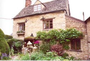
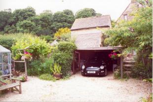
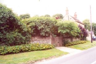
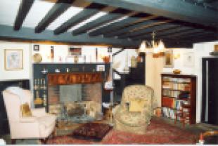
Rosebank Cottage
WITNEY, CHURCH HANBOROUGH, OXFORDSHIRE OX29 8AB
£425,000
Property details
Last sold
£635,000 Nov 2025
Local average
£237,094 (+79.3%)
Deprivation
Decile 8 (24,912 of 33,755)
Street crime
6 incidents within 1 mile (Apr 2026)
Key features
- Fine heavily beamed sitting room
- Two storey self-contained wing.
- Secluded cottage garden.
Description
Listed by
Woodstock
Breckon & Breckon
Reference: 1476487
EPC ratings on this postcode
We don't have a matched EPC for this property yet. Below are efficiency scores and details for other addresses on this postcode.
| Address | Current | Potential | Floor area | Age band | Type |
|---|---|---|---|---|---|
| 1 The Ferrets, Church Hanborough, WITNEY | 60 | 86 | 42 m² | England and Wales: 1991-1995 | Detached |
| 1 The Ferrets, Church Hanborough, WITNEY | 38 | 94 | 38 m² | England and Wales: before 1900 | Detached |
| 3 The Ferrets, Church Hanborough, WITNEY | 71 | 77 | 137 m² | England and Wales: before 1900 | Terraced |
| Amber One, Church Hanborough, WITNEY | 70 | 80 | 193 m² | England and Wales: 1967-1975 | Detached |
| Bradstones, Church Hanborough, WITNEY | 58 | 79 | 94 m² | England and Wales: 1950-1966 | Detached |
| Church View, Church Hanborough, WITNEY | 66 | 83 | 138 m² | England and Wales: before 1900 | Detached |
| Dove Cottage, Church Hanborough, WITNEY | 62 | 85 | 101 m² | England and Wales: 1983-1990 | Detached |
| Dove House, Church Hanborough, WITNEY | 73 | 80 | 240 m² | England and Wales: 1983-1990 | Detached |
| Goatley House, Church Hanborough, WITNEY | 52 | 76 | 294 m² | England and Wales: before 1900 | Detached |
| Horseshoe Cottage, Church Hanborough, WITNEY | 52 | 90 | 72 m² | England and Wales: before 1900 | Detached |
| Innisfree, Church Hanborough, WITNEY | 60 | 74 | 270 m² | England and Wales: 1950-1966 | Detached |
| Meadow House, Church Hanborough, WITNEY | 66 | 78 | 422 m² | England and Wales: 1976-1982 | Detached |
| Moss Cottage, Church Hanborough, WITNEY | 60 | 87 | 100 m² | England and Wales: before 1900 | Terraced |
| Osborne House, Church Hanborough, WITNEY | 56 | 76 | 257 m² | England and Wales: before 1900 | Detached |
| Rose Bank, Church Hanborough, WITNEY | 49 | 82 | 104 m² | England and Wales: 1900-1929 | Detached |
Flood risk
Zone: 1
Risk: Low
Job (default Low)
Price history
| Event | Date | Price | % change |
|---|---|---|---|
| Sold | 19/11/2025 (6 months ago) | £635,000 | — |
Source: HM Land Registry Price Paid Data. Crown copyright.
Sold Comparables
Sold comparables data is not available for this property.
Capital growth trend
Land Registry outcode average: last 12 months vs 5y and 10y ago (from sold prices).
House Price Index (HM Land Registry — official index, not sold-price averages): West Oxfordshire. Series: All dwelling types. As of March 2026.
Rental Range
Estimated market rent for West Oxfordshire. Low = conservative, Realistic = average, Optimistic = best case.
Based on Local Authority from postcode lookup → West Oxfordshire.
Location
Address
Church Road
Nearby
Nearest stations, universities and amenities (distance from property).
| Type | Name | Distance |
|---|---|---|
| Bus stop | Hand and Shears | 0.1 miles |
| Shop | Freeland Nurseries | 0.8 miles |
| Shop | The Cycle Shop & General Store | 0.9 miles |
| Train station | Hanborough | 1.0 miles |
| Train station | Combe | 1.5 miles |
| University | University Field Station | 3.5 miles |
| University | Azad University in Oxford | 3.6 miles |
| Hospital | Witney Community Hospital | 4.9 miles |
| Hospital | John Radcliffe Hospital | 7.7 miles |
Street-level crime
| Category | Count |
|---|---|
| Violence and sexual offences | 3 |
| Anti-social behaviour | 2 |
| Criminal damage and arson | 1 |
| Total incidents | 6 |
Within 1 mile during Apr 2026. Source: data.police.uk (England & Wales).
Schools nearby
Nearest open schools with Ofsted ratings (England). Closed schools are not shown. Data from Get Information about Schools and Ofsted.
| Name | Type | Distance | Ofsted |
|---|---|---|---|
| Hanborough Manor CofE School | Primary | 0.9 miles | Good — 7 Jul 2017 |
| Freeland Church of England Primary School | Primary | 1.1 miles | Good — 25 Nov 2011 |
| Bladon Church of England Primary School | Primary | 1.8 miles | Good — 21 Mar 2014 |
| Eynsham Community Primary School | Primary | 2.0 miles | Good — 15 Oct 2019 |
| Bartholomew School | Secondary | 2.1 miles | Outstanding — 17 Jun 2024 |
Rental Comparables
Loading rental comparables for this postcode. Refresh in a few minutes.
Rent-driven metrics
Based on Area rent estimate.
- Rent ratio — Monthly rent ÷ purchase price (1% rule). 1%+ = strong, 0.8–1% = okay, <0.8% = weak for cashflow.
- Max investor price — Rent ÷ 0.8%; the price at which rent would be 0.8% of price (Stoke-style target).
- Target investor price — Rent ÷ 1%; the price at which rent would be 1% of price (strong cashflow band).
- Gross yield — Annual rent as % of purchase price (no costs).
Enter House Number
Enter the house number to help us retrieve more accurate pricing history and property data.
Please log in to submit or correct the house number for this listing.
Log in to continue