26 NEWTON PARK COURT
LEEDS, WEST YORKSHIRE LS7 4RD
£695 pcm
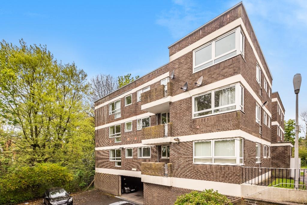
Photo 1
/ 1
Property details
Floor area
69 m²
EPC rating
D
Year built
England and Wales: 1950-1966
Deprivation
Decile 3 (8,061 of 33,755)
Street crime
706 incidents within 1 mile (Apr 2026)
Key features
- Spacious Apartment
- Brand New Kitchen
- Brand New Carpets
- Newly Decorated
- Balcony
Additional details
- Heating
- Under floor
- Parking
- Off street, Private
- Garden
- Private garden
Description
Listed by
Chapel Allerton
The Property Franchise Group
Reference: 81554622
EPC Rating & Upgrade Cost
Current rating: D
Potential rating: C
Inspection date: 06/09/2021
Expiry date: 05/09/2031
Current heating cost: £490/year
Potential heating cost: £309/year
Est. upgrade cost to C: £1,030
Recommendations
- Cavity wall insulation (£500 - £1,500)
- Low energy lighting for all fixed outlets (£30)
Flood risk
Zone: 1
Risk: Low
Job (default Low)
Rental Range
Estimated market rent for Leeds. Low = conservative, Realistic = average, Optimistic = best case.
Based on Local Authority from postcode lookup → Leeds.
LHA (30th percentile) floor for Leeds: £773/mo (Apr 2025 – Mar 2026)
Location
Nearby
Nearest stations, universities and amenities (distance from property).
| Type | Name | Distance |
|---|---|---|
| Shop | Marks Computer Clinic | 0.1 miles |
| Shop | Bike Fix Sunday | 0.2 miles |
| Bus stop | Harehills Lane Roxholme Avenue | 0.2 miles |
| University | School of Philosphy | 0.8 miles |
| Hospital | Cancer Genetics Building | 0.9 miles |
| Hospital | Paul Sykes Urology Centre | 0.9 miles |
| University | Mabgate University Centre | 1.3 miles |
| Train station | Leeds | 2.0 miles |
| Train station | Burley Park | 2.2 miles |
Street-level crime
| Category | Count |
|---|---|
| Violence and sexual offences | 305 |
| Vehicle crime | 59 |
| Public order | 55 |
| Anti-social behaviour | 48 |
| Criminal damage and arson | 44 |
| Other theft | 43 |
| Drugs | 37 |
| Burglary | 36 |
| Shoplifting | 35 |
| Other crime | 17 |
| Robbery | 15 |
| Possession of weapons | 8 |
| Theft from the person | 4 |
| Total incidents | 706 |
Within 1 mile during Apr 2026. Source: data.police.uk (England & Wales).
Schools nearby
Nearest open schools with Ofsted ratings (England). Closed schools are not shown. Data from Get Information about Schools and Ofsted.
| Name | Type | Distance | Ofsted |
|---|---|---|---|
| Bracken Edge Primary School | Primary | 0.0 miles | Good — 6 Mar 2018 |
| Al Kauthar Girls Academy | Other | 0.3 miles | Inadequate — 25 Feb 2019 |
| Hillcrest Academy | Primary | 0.4 miles | Outstanding — 8 Nov 2016 |
| Bankside Primary School | Primary | 0.4 miles | Good — 27 Apr 2011 |
| Holy Rosary and St Anne's Catholic Primary School, a Voluntary Academy | Primary | 0.6 miles | Good — 4 Mar 2013 |
Rental Comparables
Residential lets from OpenRent and Rightmove for the area (same bedroom count). Use to validate rent estimates. Student lets are excluded.
| Title | Rent | Beds | Distance | As seen on |
|---|---|---|---|---|
| 2 Bed Semi-Detached House, Ravenscar Avenue, LS8 | £2,650/mo | 2 | 0.81 miles | OpenRent |
| 2 Bed Terraced House, Ravenscar Avenue, LS8 | £2,650/mo | 2 | 0.82 miles | OpenRent |
| 2 Bed Terraced House, Wharfedale View, LS7 | £1,250/mo | 2 | 0.99 miles | OpenRent |
Average rent: £2,183/mo (3 listings)