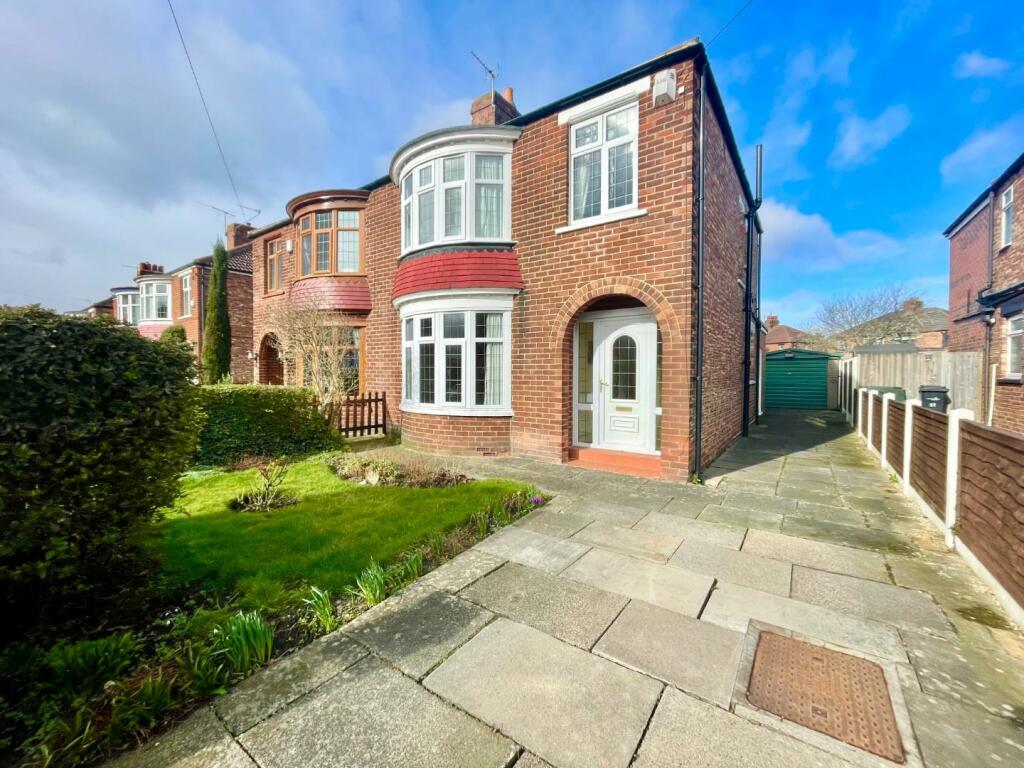
40 HEYTHROP DRIVE
MIDDLESBROUGH, MIDDLESBROUGH TS5 8QB
£170,000


Property details
Tenure
FREEHOLD
Floor area
97 m²
Council tax band
C
EPC rating
D
Year built
England and Wales: 1930-1949
Last sold
£164,000 Aug 2023
Price per m²
£1,753/m²
Local average
£174,197 (-2.4%)
Deprivation
Decile 6 (18,278 of 33,755)
Street crime
299 incidents within 1 mile (Apr 2026)
Additional details
- Parking
- Yes
- Garden
- Yes
Description
PLEASE CALL THE OFFICE ON TO ARRANGE YOUR VIEWING. IN ASSOSCIATION WITH SMITH AND FRIENDS.
FREEHOLD TENURE
COUNCIL TAX BAND C
EPC RATING D
Listed by
Middlesbrough
SMITH & FRIENDS ESTATE AGENTS LTD
Reference: 133085105
EPC Rating & Upgrade Cost
Current rating: D
Potential rating: C
Inspection date: 21/03/2023
Expiry date: 20/03/2033
Current heating cost: £1,676/year
Potential heating cost: £1,465/year
Est. upgrade cost to C: £11,675
Recommendations
- Flat roof or sloping ceiling insulation (£850 - £1,500)
- Floor insulation (suspended floor) (£800 - £1,200)
- Solar water heating (£4,000 - £6,000)
- Solar photovoltaic panels, 2.5 kWp (£3,500 - £5,500)
Flood risk
Zone: 1
Risk: Low
Job (default Low)
Floorplans

Floorplan
EPC Graphs

EE Rating
Price history
| Event | Date | Price | % change |
|---|---|---|---|
| Sold | 18/08/2023 (2 years ago) | £164,000 | — |
Source: HM Land Registry Price Paid Data. Crown copyright.
Sold Comparables
Same street and nearby sales within 0.25 miles (last 5 years). Data from Land Registry Price Paid.
| Address | Price | Date | Type |
|---|---|---|---|
| 38 ASTERLEY DRIVE, MIDDLESBROUGH, TS5 8QE | £92,000 | 09/01/2026 | Semi-detached |
| 1 WORDSWORTH VALE, MIDDLESBROUGH, TS5 8PL | £210,000 | 02/12/2025 | Semi-detached |
| 182 HEYTHROP DRIVE, MIDDLESBROUGH, TS5 8QH | £150,000 | 01/12/2025 | Semi-detached |
| 15 STONELEIGH AVENUE, MIDDLESBROUGH, TS5 8AR | £155,000 | 28/11/2025 | Semi-detached |
| 4 HADNALL CLOSE, MIDDLESBROUGH, TS5 8QP | £247,500 | 26/11/2025 | Semi-detached |
| 10 WORDSWORTH VALE, MIDDLESBROUGH, TS5 8PL | £180,000 | 17/11/2025 | Semi-detached |
| 26 MANDALE ROAD, MIDDLESBROUGH, TS5 8AF | £210,000 | 28/08/2025 | Semi-detached |
| 36 LEXDEN AVENUE, MIDDLESBROUGH, TS5 8AP | £155,000 | 02/05/2025 | Semi-detached |
| 22 RUSHLEIGH AVENUE, MIDDLESBROUGH, TS5 8PF | £215,000 | 31/03/2025 | Semi-detached |
| 4 ASTERLEY DRIVE, MIDDLESBROUGH, TS5 8QD | £180,000 | 15/12/2023 | Semi-detached |
| 35 HEYTHROP DRIVE, MIDDLESBROUGH, TS5 8QA | £235,000 | 08/12/2023 | Semi-detached |
| 36 LEXDEN AVENUE, MIDDLESBROUGH, TS5 8AP | £145,000 | 01/12/2023 | Semi-detached |
| 6 WORDSWORTH VALE, MIDDLESBROUGH, TS5 8PL | £155,000 | 30/11/2023 | Semi-detached |
| 24 HEYTHROP DRIVE, MIDDLESBROUGH, TS5 8QA | £195,000 | 07/11/2023 | Semi-detached |
| 14 CHALFORD OAKS, MIDDLESBROUGH, TS5 8QF | £160,000 | 16/10/2023 | Semi-detached |
| 21 RUSHLEIGH AVENUE, MIDDLESBROUGH, TS5 8PF | £175,000 | 20/09/2023 | Semi-detached |
| 39 ASTERLEY DRIVE, MIDDLESBROUGH, TS5 8QE | £169,995 | 29/08/2023 | Semi-detached |
| 22 MANDALE ROAD, MIDDLESBROUGH, TS5 8AF | £185,000 | 30/06/2023 | Semi-detached |
| 21 MINSTERLEY DRIVE, MIDDLESBROUGH, TS5 8QU | £160,000 | 09/06/2023 | Semi-detached |
| 24 CHALFORD OAKS, MIDDLESBROUGH, TS5 8QG | £203,620 | 03/05/2023 | Semi-detached |
| Same street 53 HEYTHROP DRIVE, MIDDLESBROUGH, TS5 8QB | £110,000 | 20/07/2022 | Semi-detached |
| Same street 59 HEYTHROP DRIVE, MIDDLESBROUGH, TS5 8QB | £200,000 | 30/06/2021 | Semi-detached |
Street average: £155,000 (2 sales)
Area average: £178,906 (20 sales)
Capital growth trend
Land Registry outcode average: last 12 months vs 5y and 10y ago (from sold prices).
House Price Index (HM Land Registry — official index, not sold-price averages): Middlesbrough. Series: Semi-detached. As of March 2026.
Rental Range
Estimated market rent for Middlesbrough. Low = conservative, Realistic = average, Optimistic = best case.
Based on Local Authority from postcode lookup → Middlesbrough.
LHA (30th percentile) floor for Teesside: £549/mo (Apr 2025 – Mar 2026)
Location
Nearby
Nearest stations, universities and amenities (distance from property).
| Type | Name | Distance |
|---|---|---|
| Bus stop | Levick Crescent | 0.2 miles |
| Shop | Londis | 0.2 miles |
| Bus stop | Acklam Coronation | 0.3 miles |
| Shop | One Stop | 0.3 miles |
| University | Durham University, Queen's Campus | 1.7 miles |
| Train station | Thornaby | 1.7 miles |
| University | Teesside University | 2.1 miles |
| Train station | James Cook | 2.3 miles |
| Hospital | Butterwick Hospice | 4.1 miles |
| Hospital | Middleton St.George Hospital | 7.0 miles |
Street-level crime
| Category | Count |
|---|---|
| Shoplifting | 112 |
| Anti-social behaviour | 63 |
| Violence and sexual offences | 56 |
| Criminal damage and arson | 25 |
| Public order | 14 |
| Other crime | 9 |
| Other theft | 5 |
| Vehicle crime | 5 |
| Burglary | 4 |
| Drugs | 2 |
| Robbery | 2 |
| Possession of weapons | 1 |
| Theft from the person | 1 |
| Total incidents | 299 |
Within 1 mile during Apr 2026. Source: data.police.uk (England & Wales).
Schools nearby
Nearest open schools with Ofsted ratings (England). Closed schools are not shown. Data from Get Information about Schools and Ofsted.
| Name | Type | Distance | Ofsted |
|---|---|---|---|
| Acklam Grange School | Secondary | 0.2 miles | Good — 29 Feb 2016 |
| Whinney Banks Primary School | Primary | 0.5 miles | Requires improvement — 9 Jan 2023 |
| Kader Academy | Primary | 0.6 miles | Good — 12 Jun 2013 |
| Green Lane Primary Academy | Primary | 0.8 miles | Good — 17 Oct 2013 |
| Acklam Whin Primary School | Primary | 0.8 miles | Good — 4 Dec 2013 |
Rental Comparables
Loading rental comparables for this postcode. Refresh in a few minutes.
Rent-driven metrics
Based on Area rent estimate.
- Rent ratio — Monthly rent ÷ purchase price (1% rule). 1%+ = strong, 0.8–1% = okay, <0.8% = weak for cashflow.
- Max investor price — Rent ÷ 0.8%; the price at which rent would be 0.8% of price (Stoke-style target).
- Target investor price — Rent ÷ 1%; the price at which rent would be 1% of price (strong cashflow band).
- Gross yield — Annual rent as % of purchase price (no costs).