FLAT 10
505 CRANBROOK ROAD, ILFORD, GREATER LONDON IG2 6ER
£675 pcm
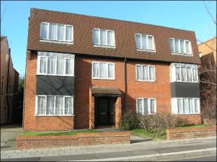
Photo 1
/ 1
Property details
Floor area
45 m²
EPC rating
C
Year built
England and Wales: 1976-1982
Deprivation
Decile 5 (14,021 of 33,755)
Street crime
457 incidents within 1 mile (Mar 2026)
Key features
- One Double Bedroom
- New Fitted Kitchen
- Allocated Parking Space
- Double Glazing
- Gas Central Heating
- 5 Minutes Central Line
- White Bathroom/w.c.
- Large Lounge
- Furnished or Part Furnished
- Must Be Seen
Description
Listed by
South Woodford
Homes & Co
Reference: 7050640
EPC Rating & Upgrade Cost
Current rating: C
Potential rating: C
Inspection date: 09/11/2020
Current heating cost: £268/year
Potential heating cost: £268/year
Flood risk
Zone: 1
Risk: Low
Job (default Low)
Company ownership
Registered legal owner is a company.
Rental Range
Estimated market rent for Redbridge. Low = conservative, Realistic = average, Optimistic = best case.
Based on Local Authority from postcode lookup → Redbridge.
LHA (30th percentile) floor for Outer North East London: £997/mo (Apr 2025 – Mar 2026)
Location
Nearby
Nearest stations, universities and amenities (distance from property).
| Type | Name | Distance |
|---|---|---|
| Shop | Top Nails | 0.0 miles |
| Shop | Ash and Nad | 0.0 miles |
| Bus stop | Gants Hill Station / Cranbrook Road | 0.1 miles |
| Bus stop | Beehive Lane | 0.1 miles |
| Train station | Gants Hill | 0.2 miles |
| Train station | Redbridge | 0.9 miles |
| Hospital | Spire London East | 1.3 miles |
| Hospital | NHS | 1.7 miles |
| University | University of East London | 3.5 miles |
Street-level crime
| Category | Count |
|---|---|
| Violence and sexual offences | 153 |
| Anti-social behaviour | 87 |
| Vehicle crime | 50 |
| Other theft | 37 |
| Shoplifting | 27 |
| Criminal damage and arson | 21 |
| Public order | 17 |
| Burglary | 16 |
| Theft from the person | 16 |
| Robbery | 10 |
| Drugs | 9 |
| Other crime | 7 |
| Possession of weapons | 6 |
| Bicycle theft | 1 |
| Total incidents | 457 |
Within 1 mile during Mar 2026. Source: data.police.uk (England & Wales).
Schools nearby
Nearest open schools with Ofsted ratings (England). Closed schools are not shown. Data from Get Information about Schools and Ofsted.
| Name | Type | Distance | Ofsted |
|---|---|---|---|
| Valentines High School | Secondary | 0.0 miles | Outstanding — 21 Nov 2021 |
| Gearies Primary School | Primary | 0.4 miles | — (Inspected (no overall grade)) |
| Cranbrook Primary School | Primary | 0.5 miles | Good — 5 Mar 2012 |
| St Augustine's Catholic Primary School | Primary | 0.6 miles | Good — 4 Feb 2016 |
| Beehive Preparatory School | Other | 0.6 miles | — (No rating) |
Rental Comparables
Residential lets from OpenRent and Rightmove for the area (same bedroom count). Use to validate rent estimates. Student lets are excluded.
| Title | Rent | Beds | Distance | As seen on |
|---|---|---|---|---|
| Studio Flat, Bramley Crescent, IG2 | £1,150/mo | 1 | 0.08 miles | OpenRent |
| 1 Bed Flat, Eastern Avenue, IG2 | £1,250/mo | 1 | 0.19 miles | OpenRent |
| Studio Flat, Lonsdale Crescent, IG2 | £1,300/mo | 1 | 0.2 miles | OpenRent |
| Studio Flat, Gaysham Avenue, IG2 | £1,000/mo | 1 | 0.3 miles | OpenRent |
| Studio Flat, Wycombe Road, IG2 | £1,200/mo | 1 | 0.37 miles | OpenRent |
Average rent: £1,180/mo (5 listings)