50 TENBY DRIVE
LUTON, LUTON LU4 9BL
£110,000
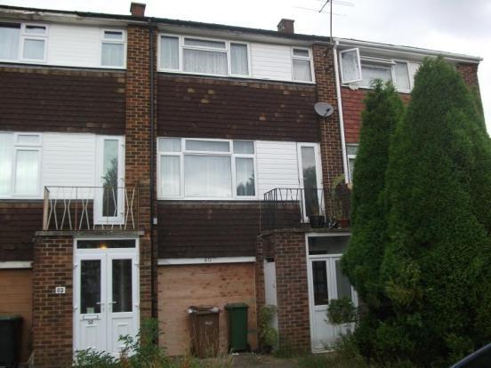
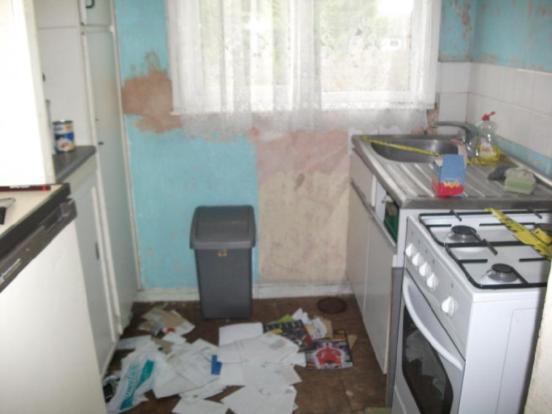
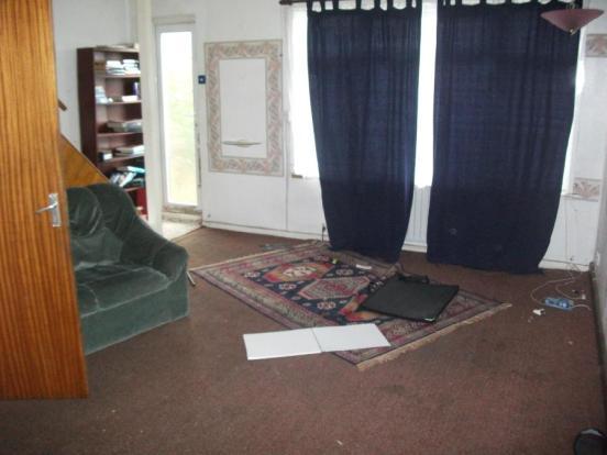
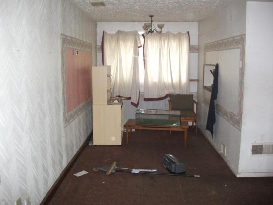
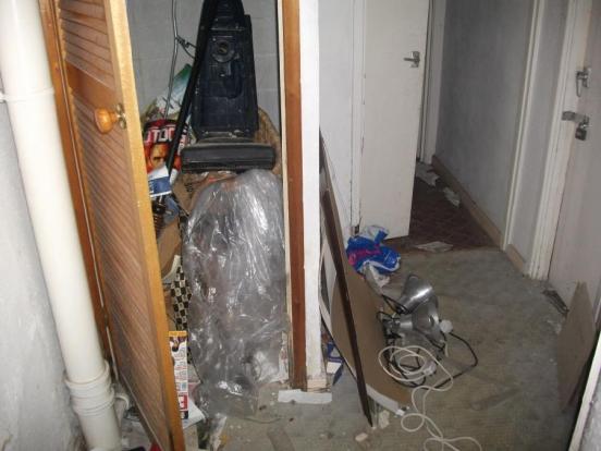

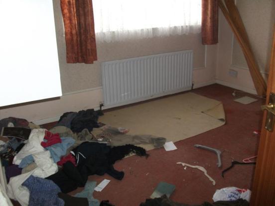
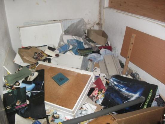
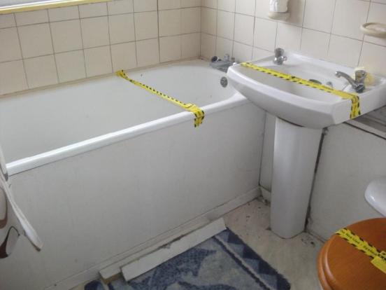
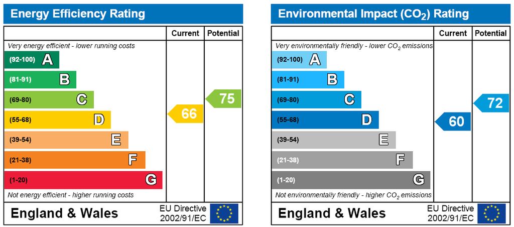
Photo 1 Photo 2 Photo 3 Photo 4 Photo 5 Photo 6 Photo 7 Photo 8 Photo 9 EPC
/ 10
Property details
Floor area
94 m²
EPC rating
C
Year built
England and Wales: 1967-1975
Last sold
£125,000 May 2013
Price per m²
£1,170/m²
Local average
£275,560 (-60.1%)
Deprivation
Decile 4 (10,695 of 33,755)
Street crime
320 incidents within 1 mile (Apr 2026)
Additional details
- Parking
- Yes
- Garden
- Yes
Description
Further benefits include double glazing (w/s) schools, shops, banks, Junction 11 of the M1, Leagrave mainline railway station can all be found locally.
The property is in need of modernisation.
Entrance Hall
Downstairs W.C.
Shower Cubicle
Ground Floor Bedroom 10ft 6 x 6ft 9
Integral Garage
Kitchen 6ft 9 x 5ft 8
Lounge/Diner 22ft 10 x 14ft 10 narrowing to 7ft 6
Bedroom One 10ft 11 x 11ft 8
Bedroom Two 12ft x 7ft 5
Bathroom
Front & Rear Gardens
Listed by
Leagrave
Countrywide UK Sales - Connells
Reference: 27261577
EPC Rating & Upgrade Cost
Current rating: C
Potential rating: B
Inspection date: 28/02/2013
Expiry date: 27/02/2023 (expired)
Current heating cost: £551/year
Potential heating cost: £429/year
Est. upgrade cost to C: £16,725
Recommendations
- Increase loft insulation to 270 mm (£100 - £350)
- Solar water heating (£4,000 - £6,000)
- Solar photovoltaic panels, 2.5 kWp (£9,000 - £14,000)
Flood risk
Zone: 1
Risk: Low
Job (default Low)
Floorplans
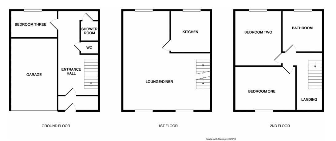
Floorplan 1
Price history
62% since 2000
| Event | Date | Price | % change |
|---|---|---|---|
| Sold | 03/05/2013 (13 years ago) | £125,000 | +62.3% |
| Sold | 17/11/2000 (25 years ago) | £77,000 | — |
Source: HM Land Registry Price Paid Data. Crown copyright.
Sold Comparables
Same street and nearby sales within 0.25 miles (last 5 years). Data from Land Registry Price Paid.
| Address | Price | Date | Type |
|---|---|---|---|
| 139 BEECHWOOD ROAD, LUTON, LU4 9RX | £125,000 | 28/11/2025 | Terraced |
| 55 PEMBROKE AVENUE, LUTON, LU4 9BH | £260,000 | 20/11/2023 | Terraced |
| 25 SEATON ROAD, LUTON, LU4 9SL | £319,000 | 03/11/2023 | Terraced |
| Same street 125 TENBY DRIVE, LUTON, LU4 9BL | £230,000 | 29/03/2023 | Terraced |
| 139 BEECHWOOD ROAD, LUTON, LU4 9RX | £141,600 | 23/03/2023 | Terraced |
| 167 TENBY DRIVE, LUTON, LU4 9BN | £325,000 | 20/12/2022 | Terraced |
| 19 PEMBROKE AVENUE, LUTON, LU4 9BH | £318,000 | 09/12/2022 | Terraced |
| 14 DAWLISH ROAD, LUTON, LU4 9SD | £330,000 | 02/11/2022 | Terraced |
| 92 WALLER AVENUE, LUTON, LU4 9RR | £270,000 | 31/10/2022 | Terraced |
| 102 CHESTER AVENUE, LUTON, LU4 9SQ | £310,000 | 19/10/2022 | Terraced |
| 6 MALHAM CLOSE, LUTON, LU4 8PH | £190,000 | 12/10/2022 | Terraced |
| Same street 34 TENBY DRIVE, LUTON, LU4 9BL | £305,000 | 03/10/2022 | Semi-detached |
| 36 LEAFIELD, LUTON, LU3 2SB | £285,000 | 23/09/2022 | Terraced |
| 18 WICKSTEAD AVENUE, LUTON, LU4 9DP | £323,000 | 09/09/2022 | Terraced |
| 202 BEECHWOOD ROAD, LUTON, LU4 9SA | £230,000 | 08/09/2022 | Terraced |
| 77 CHESTER AVENUE, LUTON, LU4 9SQ | £305,000 | 24/08/2022 | Terraced |
| 14 WICKSTEAD AVENUE, LUTON, LU4 9DP | £305,000 | 15/08/2022 | Terraced |
| 86 TENBY DRIVE, LUTON, LU4 9BN | £315,000 | 18/07/2022 | Terraced |
| 17 MALHAM CLOSE, LUTON, LU4 8PH | £260,000 | 27/05/2022 | Terraced |
| 29 CHILTERN GARDENS, LUTON, LU4 9RL | £178,500 | 25/04/2022 | Terraced |
| 153 CHESTER AVENUE, LUTON, LU4 9SH | £290,000 | 14/04/2022 | Terraced |
| 3 BODMIN ROAD, LUTON, LU4 9BW | £307,700 | 11/04/2022 | Terraced |
| Same street 115 TENBY DRIVE, LUTON, LU4 9BL | £307,000 | 04/02/2022 | Semi-detached |
| Same street 58 TENBY DRIVE, LUTON, LU4 9BL | £250,000 | 10/12/2021 | Terraced |
Street average: £273,000 (4 sales)
Area average: £269,390 (20 sales)
Capital growth trend
Land Registry outcode average: last 12 months vs 5y and 10y ago (from sold prices).
House Price Index (HM Land Registry — official index, not sold-price averages): Luton. Series: Terraced. As of March 2026.
Rental Range
Estimated market rent for Luton. Low = conservative, Realistic = average, Optimistic = best case.
Based on Local Authority from postcode lookup → Luton.
LHA (30th percentile) floor for Luton: £1,097/mo (Apr 2025 – Mar 2026)
Location
Nearby
Nearest stations, universities and amenities (distance from property).
| Type | Name | Distance |
|---|---|---|
| Shop | Afghan | 0.1 miles |
| Shop | Hamza Supermarket | 0.2 miles |
| Bus stop | Maidenhall Beechwood | 0.3 miles |
| Train station | Leagrave | 0.6 miles |
| Hospital | Luton and Dunstable Hospital | 1.0 miles |
| Hospital | Widecombe Nursing Home | 1.7 miles |
| Train station | Luton | 2.0 miles |
| University | University of Bedfordshire | 2.3 miles |
Street-level crime
| Category | Count |
|---|---|
| Violence and sexual offences | 134 |
| Anti-social behaviour | 54 |
| Criminal damage and arson | 25 |
| Vehicle crime | 22 |
| Public order | 21 |
| Drugs | 20 |
| Other theft | 17 |
| Other crime | 10 |
| Burglary | 7 |
| Shoplifting | 5 |
| Possession of weapons | 3 |
| Robbery | 1 |
| Theft from the person | 1 |
| Total incidents | 320 |
Within 1 mile during Apr 2026. Source: data.police.uk (England & Wales).
Schools nearby
Nearest open schools with Ofsted ratings (England). Closed schools are not shown. Data from Get Information about Schools and Ofsted.
| Name | Type | Distance | Ofsted |
|---|---|---|---|
| Beechwood Primary School | Primary | 0.3 miles | Good — 14 Oct 2019 |
| Norton Road Primary School | Primary | 0.4 miles | Good — 13 May 2024 |
| St Joseph's Catholic Primary School | Primary | 0.5 miles | Good — 6 Dec 2017 |
| Downside Primary School | Primary | 0.6 miles | Good — 5 Jun 2015 |
| Challney High School for Girls | Secondary | 0.6 miles | Outstanding — 10 Feb 2020 |
Rental Comparables
Loading rental comparables for this postcode. Refresh in a few minutes.
Rent-driven metrics
Based on Area rent estimate.
- Rent ratio — Monthly rent ÷ purchase price (1% rule). 1%+ = strong, 0.8–1% = okay, <0.8% = weak for cashflow.
- Max investor price — Rent ÷ 0.8%; the price at which rent would be 0.8% of price (Stoke-style target).
- Target investor price — Rent ÷ 1%; the price at which rent would be 1% of price (strong cashflow band).
- Gross yield — Annual rent as % of purchase price (no costs).