Calf Hall Mill
CALF HALL ROAD, BARNOLDSWICK, LANCASHIRE BB18 5PX
POA
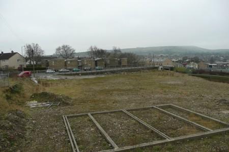
Photo 1
/ 1
Property details
Last sold
£750,000 Apr 2009
Local average
£193,875 (+157.9%)
Deprivation
Decile 7 (21,291 of 33,755)
Street crime
42 incidents within 1 mile (Apr 2026)
Description
0.4 hectares.
Situated on the edge of Barnoldswick.
Adjacent to the Leeds and Liverpool Canal.
Partial foundations constructed.
Location
The site extends to approximately 0.4 hectares and was formerly occupied by a Mill that was demolished and cleared approximately 2 years ago.
The site bounds the east bank of the Leeds and Liverpool Canal adjacent to Coates Bridge and is conveniently located for the facilities available within Barnoldswick town centre (see location plan).
Description
A generally level site bounded by Skipton Road to the front, the Leeds and Liverpool Canal to the east and residential properties to the other elevations.
Accommodation
Site area 0.4 hectares.
Services
We are advised that all mains services are available on Skipton Road. It is the prospective purchaser's responsibility to verify that all services are in working order and are of adequate capacity and suitable for their purpose.
Site Investigation
Access can be made available for parties requiring further investigation, subject to prior confirmation and appointment. We will require indemnification in respect of any third party claims howsoever arising as a result of an inspection being undertaken.
Planning
Planning permission has been granted for the erection of 21, 3 storey townhouses.
Enquiries regarding this Application and any alternate use should be referred to Pendle Borough Council on 01282 661661, Application Reference 13/06/0771P.
Listed by
Burnley - Commercial
Petty Real
Reference: 33592597
EPC ratings on this postcode
We don't have a matched EPC for this property yet. Below are efficiency scores and details for other addresses on this postcode.
| Address | Current | Potential | Floor area | Age band | Type |
|---|---|---|---|---|---|
| 1 Calf Hall Road, BARNOLDSWICK | 74 | 85 | 105 m² | England and Wales: before 1900 | Terraced |
| 10, Calf Hall Road, BARNOLDSWICK | 64 | 85 | 84 m² | England and Wales: before 1900 | Terraced |
| 14, Calf Hall Road, BARNOLDSWICK | 64 | 81 | 93 m² | England and Wales: 1900-1929 | Terraced |
| 17 Calf Hall Road, BARNOLDSWICK | 75 | 79 | 138 m² | England and Wales: before 1900 | Terraced |
| 17 Calf Hall Road, BARNOLDSWICK | 49 | 75 | 120 m² | England and Wales: 1900-1929 | Terraced |
| 18, Calf Hall Road, BARNOLDSWICK | 55 | 72 | 111 m² | England and Wales: 1900-1929 | Terraced |
| 20, Calf Hall Road, BARNOLDSWICK | 66 | 86 | 85 m² | England and Wales: before 1900 | Terraced |
| 21a Calf Hall Road, BARNOLDSWICK | 42 | 73 | 74 m² | England and Wales: before 1900 | Flat |
| 24, Calf Hall Road, BARNOLDSWICK | 58 | 76 | 94 m² | England and Wales: before 1900 | Terraced |
| 24, Calf Hall Road, BARNOLDSWICK | 29 | 56 | 90 m² | England and Wales: 1900-1929 | Terraced |
| 28, Calf Hall Road, BARNOLDSWICK | 54 | 82 | 91 m² | England and Wales: 1900-1929 | Terraced |
| 30, Calf Hall Road, BARNOLDSWICK | 67 | 85 | 91 m² | England and Wales: before 1900 | Terraced |
| 34 Calf Hall Road, BARNOLDSWICK | 55 | 79 | 111 m² | England and Wales: before 1900 | Terraced |
| 5 Calf Hall Road, BARNOLDSWICK | 71 | 89 | 72 m² | England and Wales: before 1900 | Terraced |
| 6, Calf Hall Road, BARNOLDSWICK | 55 | 76 | 122 m² | England and Wales: 1900-1929 | Terraced |
Flood risk
Zone: 1
Risk: Low
Job (default Low)
Price history
| Event | Date | Price | % change |
|---|---|---|---|
| Sold | 07/04/2009 (17 years ago) | £750,000 | — |
Source: HM Land Registry Price Paid Data. Crown copyright.
Sold Comparables
Same street and nearby sales within 0.25 miles (last 5 years). Data from Land Registry Price Paid.
| Address | Price | Date | Type |
|---|---|---|---|
| AUTOTEK COMMERCIAL STREET, BARNOLDSWICK, PENDLE, LANCASHIRE, BB18 5NY | £80,000 | 18/02/2022 | Other |
Area average: £80,000 (1 sale)
Capital growth trend
Land Registry outcode average: last 12 months vs 5y and 10y ago (from sold prices).
House Price Index (HM Land Registry — official index, not sold-price averages): Pendle. Series: All dwelling types. As of March 2026.
Rental Range
Estimated market rent for Pendle. Low = conservative, Realistic = average, Optimistic = best case.
Based on Local Authority from postcode lookup → Pendle.
LHA (30th percentile) floor for Bradford & South Dales: Apr 2025 – Mar 2026
Location
Address
Calf Hall Road
Nearby
Nearest stations, universities and amenities (distance from property).
| Type | Name | Distance |
|---|---|---|
| Bus stop | Sunday School | 0.1 miles |
| Shop | Helliwells Funeral Services | 0.1 miles |
| Shop | Unknown | 0.1 miles |
| Hospital | health center | 4.1 miles |
| Train station | Colne | 4.2 miles |
| Train station | Gargrave | 5.6 miles |
| Hospital | Burnley General Hospital | 7.5 miles |
| University | UClan burnley temp | 9.0 miles |
| University | UCLan Burnley Campus | 9.0 miles |
Street-level crime
| Category | Count |
|---|---|
| Violence and sexual offences | 23 |
| Anti-social behaviour | 6 |
| Shoplifting | 4 |
| Public order | 3 |
| Other theft | 2 |
| Vehicle crime | 2 |
| Burglary | 1 |
| Criminal damage and arson | 1 |
| Total incidents | 42 |
Within 1 mile during Apr 2026. Source: data.police.uk (England & Wales).
Schools nearby
Nearest open schools with Ofsted ratings (England). Closed schools are not shown. Data from Get Information about Schools and Ofsted.
| Name | Type | Distance | Ofsted |
|---|---|---|---|
| Gisburn Road Community Primary School | Primary | 0.3 miles | Good — 22 May 2015 |
| St Joseph's Catholic primary School, a Voluntary Academy | Primary | 0.5 miles | Good — 26 Apr 2023 |
| Barnoldswick Church of England Controlled Primary School | Primary | 0.5 miles | Good — 21 Sep 2022 |
| West Craven High School | Secondary | 0.5 miles | Requires improvement — 9 Sep 2024 |
| Coates Lane Primary School | Primary | 0.8 miles | Good — 15 Jul 2015 |
Rental Comparables
Residential lets from OpenRent and Rightmove for the area. Bedroom counts vary — use the Beds column to compare like-for-like lets. Student lets are excluded.
| Title | Rent | Beds | Distance | As seen on |
|---|---|---|---|---|
| 3 Bed Semi-Detached House, Malham View Close, BB18 | £900/mo | 3 | 0.12 miles | OpenRent |
| 3 Bed Terraced House, West Ave, BB18 | £895/mo | 3 | 0.32 miles | OpenRent |
| 3 Bed Terraced House, Craven Street, BB18 | £750/mo | 3 | 0.39 miles | OpenRent |
Average rent: £848/mo (3 listings)
Rent-driven metrics
Based on OpenRent comparables.
- Rent ratio — Monthly rent ÷ purchase price (1% rule). 1%+ = strong, 0.8–1% = okay, <0.8% = weak for cashflow.
- Max investor price — Rent ÷ 0.8%; the price at which rent would be 0.8% of price (Stoke-style target).
- Target investor price — Rent ÷ 1%; the price at which rent would be 1% of price (strong cashflow band).
- Gross yield — Annual rent as % of purchase price (no costs).
- Cost-to-rent — Price ÷ annual rent (from OpenRent comparables). Under 14× = strong, 14–16× = acceptable, 17×+ = compressed.
- Cashflow — Rent minus mortgage, 10% maintenance, £25/mo compliance. Assumes 75% LTV, 3.95% APR (5yr fixed), 25yr term.
- ROI — Annual profit ÷ cash in (deposit + 4% purchase costs).
Enter House Number
Enter the house number to help us retrieve more accurate pricing history and property data.
Please log in to submit or correct the house number for this listing.
Log in to continue