Birdham Stores
MAIN ROAD, CHICHESTER, BIRDHAM, WEST SUSSEX PO20 7HU
£797 pcm
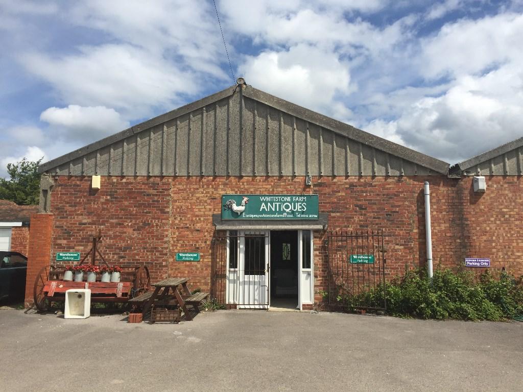
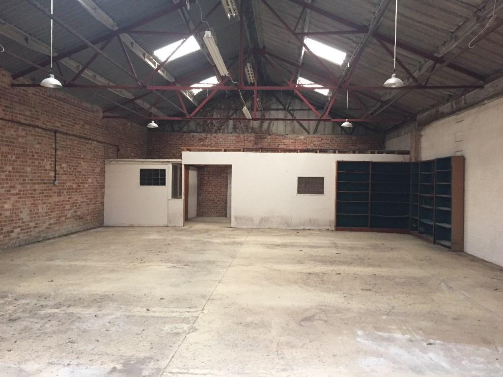
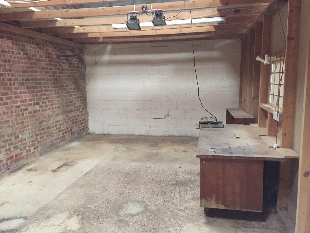
Photo 1 Photo 2 Photo 3
/ 3
Property details
Last sold
£425,000 May 2004
Local average
£2,148,511 (-100%)
Deprivation
Decile 8 (26,147 of 33,755)
Street crime
17 incidents within 1 mile (Apr 2026)
Key features
- Commercial Unit Extending to 2153 sq ft
- Off Road Parking
- Small office area
- W/C Facilities
Additional details
- Parking
- Off street
Description
The unit comprises a small office area to the rear of the unit with the remaining space comprising storage/ workshop space with concrete floor. A w/c facility is situated at the front of the unit.
The current access is via pedestrian doors only, however the installation of a roller shutter door may be considered.
Outside the unit offers three allocated car parking spaces.
Listed by
Haywards Heath
Savills
Reference: 60391589
EPC ratings on this postcode
We don't have a matched EPC for this property yet. Below are efficiency scores and details for other addresses on this postcode.
| Address | Current | Potential | Floor area | Age band | Type |
|---|---|---|---|---|---|
| 1 The Straight, Main Road, Birdham, CHICHESTER | 84 | 94 | 123 m² | — | Detached |
| 1 Whitestone Farm Cottages, Main Road, CHICHESTER | 62 | 88 | 72 m² | England and Wales: before 1900 | Terraced |
| 2 The Straight, Main Road, Birdham, CHICHESTER | 84 | 94 | 123 m² | — | Detached |
| 2 The Straight, Main Road, Birdham, CHICHESTER | 85 | 93 | 173 m² | — | Detached |
| 3 The Straight, Main Road, Birdham, CHICHESTER | 85 | 93 | 173 m² | — | Detached |
| Ayton, Main Road, Birdham, CHICHESTER | 57 | 81 | 74 m² | England and Wales: 1900-1929 | Detached |
| Flat 1, The Cottage Birdham Store, CHICHESTER | 15 | 70 | 62 m² | England and Wales: 1900-1929 | Flat |
| Flat 2, The Cottage Birdham Store, Main Road, CHICHESTER | 42 | 68 | 63 m² | England and Wales: 1900-1929 | Flat |
| Ridings, Main Road, Birdham, CHICHESTER | 74 | 91 | 131 m² | England and Wales: 1950-1966 | Detached |
| Rustic, Main Road, Birdham, CHICHESTER | 37 | 70 | 76 m² | England and Wales: 1983-1990 | Detached |
| Spinnaker, Main Road, Birdham, CHICHESTER | 85 | 92 | 145 m² | — | Detached |
| STRATHMORE, MAIN ROAD, BIRDHAM, BIRDHAM | 47 | 69 | 60 m² | England and Wales: 1930-1949 | Detached |
| Strathmore, Main Road, Birdham, CHICHESTER | 73 | 84 | 111 m² | England and Wales: 1930-1949 | Detached |
Flood risk
Zone: 1
Risk: Low
Job (default Low)
Price history
| Event | Date | Price | % change |
|---|---|---|---|
| Sold | 27/05/2004 (22 years ago) | £425,000 | — |
Source: HM Land Registry Price Paid Data. Crown copyright.
Sold Comparables
Same street and nearby sales within 0.25 miles (last 5 years). Data from Land Registry Price Paid.
| Address | Price | Date | Type |
|---|---|---|---|
| Same street STRATHMORE MAIN ROAD, BIRDHAM, CHICHESTER, WEST SUSSEX, PO20 7HU | £630,000 | 28/11/2023 | Detached |
| Same street WHITESTONE FARM COTTAGES 1 MAIN ROAD, BIRDHAM, CHICHESTER, WEST SUSSEX, PO20 7HU | £350,000 | 11/07/2023 | Terraced |
Street average: £490,000 (2 sales)
Capital growth trend
Land Registry outcode average: last 12 months vs 5y and 10y ago (from sold prices).
House Price Index (HM Land Registry — official index, not sold-price averages): Chichester. Series: All dwelling types. As of March 2026.
Rental Range
Estimated market rent for Chichester. Low = conservative, Realistic = average, Optimistic = best case.
Based on Local Authority from postcode lookup → Chichester.
LHA (30th percentile) floor for Chichester: Apr 2025 – Mar 2026
Location
Address
A286
Nearby
Nearest stations, universities and amenities (distance from property).
| Type | Name | Distance |
|---|---|---|
| Shop | Nisa Local | 0.1 miles |
| Bus stop | Birdham Stores | 0.2 miles |
| Shop | Little Waitrose | 0.3 miles |
| University | Stockbridge Halls of Residence | 3.4 miles |
| Train station | Fishbourne | 3.5 miles |
| University | Fishbourne Hall | 3.5 miles |
| Train station | Chichester | 3.7 miles |
| Hospital | Nuffield Health Chichester Hospital | 4.6 miles |
| Hospital | St Richard's Hospital | 4.7 miles |
Street-level crime
| Category | Count |
|---|---|
| Anti-social behaviour | 6 |
| Criminal damage and arson | 4 |
| Violence and sexual offences | 3 |
| Possession of weapons | 1 |
| Public order | 1 |
| Shoplifting | 1 |
| Vehicle crime | 1 |
| Total incidents | 17 |
Within 1 mile during Apr 2026. Source: data.police.uk (England & Wales).
Schools nearby
Nearest open schools with Ofsted ratings (England). Closed schools are not shown. Data from Get Information about Schools and Ofsted.
| Name | Type | Distance | Ofsted |
|---|---|---|---|
| Birdham CE Primary School | Primary | 0.3 miles | Good — 10 Nov 2022 |
| Sidlesham Primary School | Primary | 1.8 miles | Requires improvement — 21 Jul 2024 |
| East Wittering Community Primary School | Primary | 2.2 miles | Good — 18 Jul 2017 |
| West Wittering Parochial Church of England School | Primary | 2.9 miles | Good — 11 Dec 2022 |
| Bosham Primary School | Primary | 3.1 miles | Good — 16 Dec 2018 |
Rental Comparables
Rental comparables are temporarily unavailable while listing-site fetches are paused. Try again later.
Rent-driven metrics
Based on Area rent estimate.
- Rent ratio — Monthly rent ÷ purchase price (1% rule). 1%+ = strong, 0.8–1% = okay, <0.8% = weak for cashflow.
- Max investor price — Rent ÷ 0.8%; the price at which rent would be 0.8% of price (Stoke-style target).
- Target investor price — Rent ÷ 1%; the price at which rent would be 1% of price (strong cashflow band).
- Gross yield — Annual rent as % of purchase price (no costs).
Enter House Number
Enter the house number to help us retrieve more accurate pricing history and property data.
Please log in to submit or correct the house number for this listing.
Log in to continue