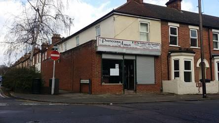
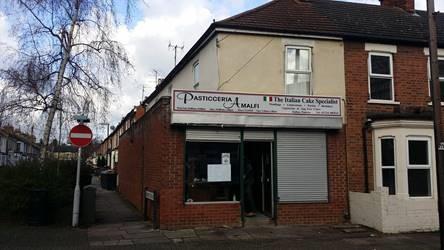
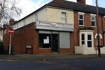
27 PARK ROAD WEST
BEDFORD, BEDFORD MK41 7SB
£750 pcm
Property details
Tenure
LEASEHOLD
Floor area
29 m²
EPC rating
C
Year built
England and Wales: before 1900
Last sold
£60,000 Aug 2000
Price per m²
£26/m²
Local average
£375,000 (-99.8%)
Deprivation
Decile 2 (6,225 of 33,755)
Street crime
531 incidents within 1 mile (Apr 2026)
Description
prominent corner in the sought after Prime Ministers
area in Bedford.
The property consists of a ground floor retail unit with
an open plan retail space leading to a rear storage
room and wc.
Floor Area Sq M Sq Ft
Ground Floor 68.19 734
Listed by
Bedford
Fisher German
Reference: 58504444
EPC Rating & Upgrade Cost
Current rating: C
Potential rating: C
Inspection date: 20/04/2023
Expiry date: 19/04/2033
Current heating cost: £346/year
Potential heating cost: £346/year
Flood risk
Zone: 1
Risk: Low
Job (default Low)
Price history
| Event | Date | Price | % change |
|---|---|---|---|
| Sold | 21/08/2000 (25 years ago) | £60,000 | — |
Source: HM Land Registry Price Paid Data. Crown copyright.
Sold Comparables
Same street and nearby sales within 0.25 miles (last 5 years). Data from Land Registry Price Paid.
| Address | Price | Date | Type |
|---|---|---|---|
| 30 ROFF AVENUE, BEDFORD, MK41 7TE | £145,000 | 01/12/2025 | Other |
| 139 - 145 TAVISTOCK STREET, BEDFORD, MK40 2SB | £2,800,000 | 04/08/2022 | Other |
| 117 TAVISTOCK STREET, BEDFORD, MK40 2SB | £550,000 | 28/10/2021 | Other |
| 135 - 137 TAVISTOCK STREET, BEDFORD, MK40 2SB | £260,000 | 01/09/2021 | Other |
Area average: £938,750 (4 sales)
Capital growth trend
Land Registry outcode average: last 12 months vs 5y and 10y ago (from sold prices).
House Price Index (HM Land Registry — official index, not sold-price averages): Bedford. Series: All dwelling types. As of March 2026.
Rental Range
Estimated market rent for Bedford. Low = conservative, Realistic = average, Optimistic = best case.
Based on Local Authority from postcode lookup → Bedford.
LHA (30th percentile) floor for Bedford: Apr 2025 – Mar 2026
Location
Nearby
Nearest stations, universities and amenities (distance from property).
| Type | Name | Distance |
|---|---|---|
| Shop | Queens Corner Store | 0.0 miles |
| Shop | Neville Memorials | 0.0 miles |
| Bus stop | Warwick Avenue | 0.2 miles |
| Bus stop | Unknown | 0.2 miles |
| Hospital | Bedford Health Village | 0.6 miles |
| Train station | Bedford | 0.6 miles |
| Train station | Bedford St Johns | 0.9 miles |
| Hospital | Bedford Hospital South Wing | 1.0 miles |
| University | University of Bedfordshire Polhill Campus | 1.3 miles |
| University | Cranfield University | 8.3 miles |
Street-level crime
| Category | Count |
|---|---|
| Violence and sexual offences | 189 |
| Anti-social behaviour | 86 |
| Shoplifting | 63 |
| Public order | 37 |
| Criminal damage and arson | 28 |
| Other theft | 26 |
| Vehicle crime | 22 |
| Drugs | 20 |
| Burglary | 14 |
| Other crime | 13 |
| Robbery | 11 |
| Bicycle theft | 9 |
| Possession of weapons | 8 |
| Theft from the person | 5 |
| Total incidents | 531 |
Within 1 mile during Apr 2026. Source: data.police.uk (England & Wales).
Schools nearby
Nearest open schools with Ofsted ratings (England). Closed schools are not shown. Data from Get Information about Schools and Ofsted.
| Name | Type | Distance | Ofsted |
|---|---|---|---|
| Livingstone Primary School | Primary | 0.2 miles | Good — 18 May 2023 |
| Polam School | Other | 0.3 miles | — (No rating) |
| Bedford School | Other | 0.4 miles | — (No rating) |
| Priory Primary School | Primary | 0.4 miles | — (Inspected (no overall grade)) |
| Edith Cavell Primary School | Primary | 0.4 miles | Good — 21 Oct 2014 |
Rental Comparables
Residential lets from OpenRent and Rightmove for the area. Bedroom counts vary — use the Beds column to compare like-for-like lets. Student lets are excluded.
| Title | Rent | Beds | Distance | As seen on |
|---|---|---|---|---|
| Studio Flat, Foster Hill Road, MK40 | £800/mo | 1 | 0.15 miles | OpenRent |
| 3 Bed End Terrace, Gladstone St, MK41 | £1,400/mo | 3 | 0.22 miles | OpenRent |
| 3 Bed End Terrace, Hartington St, MK41 | £1,625/mo | 3 | 0.23 miles | OpenRent |
| Studio Flat, Bromham Road, MK40 | £750/mo | 1 | 0.29 miles | OpenRent |
Average rent: £1,144/mo (4 listings)
Rent-driven metrics
Based on OpenRent comparables.
- Rent ratio — Monthly rent ÷ purchase price (1% rule). 1%+ = strong, 0.8–1% = okay, <0.8% = weak for cashflow.
- Max investor price — Rent ÷ 0.8%; the price at which rent would be 0.8% of price (Stoke-style target).
- Target investor price — Rent ÷ 1%; the price at which rent would be 1% of price (strong cashflow band).
- Gross yield — Annual rent as % of purchase price (no costs).
- Cost-to-rent — Price ÷ annual rent (from OpenRent comparables). Under 14× = strong, 14–16× = acceptable, 17×+ = compressed.
- Cashflow — Rent minus mortgage, 10% maintenance, £25/mo compliance. Assumes 75% LTV, 3.95% APR (5yr fixed), 25yr term.
- ROI — Annual profit ÷ cash in (deposit + 4% purchase costs).