Liverpool Road
Newcastle Under Lyme, ST5, ST5 9DX
£680 pcm
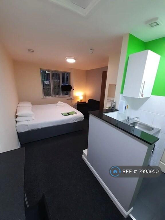
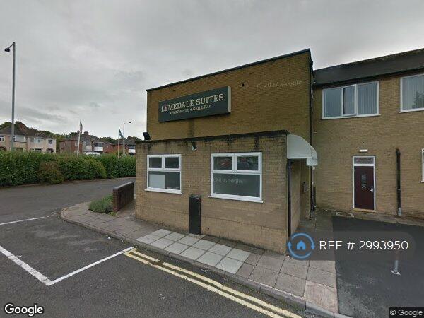
Photo 1 Photo 2
/ 2
Property details
Deprivation
Decile 4 (12,689 of 33,755)
Street crime
203 incidents within 1 mile (Aug 2026)
Key features
- No Agent Fees
- Students Can Enquire
- Bills Included
- Property Reference Number: 2993950
Additional details
- Parking
- Private
Description
Studio Flat, Liverpool Road, ST5
Overview
Bedrooms1
Bathrooms1
Max Tenants2
LocationNewcastle Under Lyme
Description
ALL BILLS INCLUDED
Ideal for medium-term stays, this property offers fully self-contained suites with modern amenities. On-site reception is available Monday to Friday, with a live-in Night Porter for added convenience and security.
Each suite includes:
En-suite bathroom with shower
Kitchenette with electric hobs, microwave, and under-counter fridge/freezer
Fully furnished with a double bed, wardrobe, sofa, TV, and breakfast bar
Please note: quilts, pillows, cookware, and utensils are not provided.
Location
Conveniently situated just 1.8 miles from Newcastle-under-Lyme town centre and a 10-minute drive from Stoke Railway Station. The property is located on the A34, with easy access to Junction 16 of the M6. Keele University and the Royal Stoke University Hospital are both within a 10-minute drive.
Located at the entrance of the Lymedale Business Park, home to major distribution centres such as New Look, TK Maxx, and George at ASDA. Multiple bus routes (1, 4, 4A, and 37) run from stops along the main road, providing direct access to town and the hospital.
Nearby Amenities
Morrisons supermarket within walking distance
Lidl, Aldi, and Sainsbury’s all within a 10-minute drive
On-site bar and restaurant serving home-cooked meals
Additional Features
Free WiFi throughout
Large on-site car park
Coin-operated laundry facilities available for guest use
Viewing available Monday to Friday 9am to 5pm Couples or single persons.
Summary & Exclusions:
- Rent Amount: £680.00 per month (£156.92 per week)
- Deposit / Bond: £680.00
- 1 Bedrooms
- 1 Bathrooms
- Property comes furnished
- Available to move in from 27 October 2026
- Maximum number of tenants is 2
- Students welcome to enquire
- Smokers considered
- Bills Included
- Property has parking
- No Garden Access
- EPC Rating: B
If calling, please quote reference: 2993950
Fees:
You will not be charged any admin fees.
Contact today to book a viewing and have the landlord show you round!
Request Details form responded to 24/7, with phone bookings available 9am-9pm, 7 days a week.
Listed by
London
Techbeard Ltd
Reference: 94813155
Flood risk
Zone: 1
Risk: Low
Job (default Low)
Registered land (INSPIRE)
This location falls inside an HM Land Registry INSPIRE registered freehold polygon.
Building plot (shared): ~6,384 m² (1.58 acres) (area is for the building, not the flat)
Source: HM Land Registry INSPIRE Index Polygons.
Rental Range
Estimated market rent for Newcastle-under-Lyme. Low = conservative, Realistic = average, Optimistic = best case.
Based on Local Authority from postcode lookup → Newcastle-under-Lyme.
LHA (30th percentile) floor for Staffordshire North: £424/mo (Apr 2025 – Mar 2026)
Location
Address
Liverpool Road
Nearby
Nearest stations, universities and amenities (distance from property).
| Type | Name | Distance |
|---|---|---|
| Bus stop | Liverpool Road | 0.1 miles |
| Bus stop | Wolstanton Golf Course | 0.1 miles |
| Shop | Samsung Support Centre | 0.3 miles |
| Shop | Meelie Mobile | 0.3 miles |
| Train station | Silverdale | 1.2 miles |
| Train station | Longport | 1.2 miles |
| Hospital | Royal Stoke University Hospital | 2.1 miles |
| University | Keele University | 2.4 miles |
| Hospital | Haywood Hospital Walk-in Centre | 2.7 miles |
| University | University of Buckingham Crewe Campus | 8.8 miles |
Street-level crime
| Category | Count |
|---|---|
| Violence and sexual offences | 89 |
| Anti-social behaviour | 51 |
| Public order | 16 |
| Shoplifting | 9 |
| Criminal damage and arson | 8 |
| Burglary | 7 |
| Other crime | 7 |
| Other theft | 6 |
| Drugs | 5 |
| Possession of weapons | 2 |
| Bicycle theft | 1 |
| Robbery | 1 |
| Vehicle crime | 1 |
| Total incidents | 203 |
Within 1 mile during Aug 2026. Source: data.police.uk (England & Wales).
Schools nearby
Nearest open schools with Ofsted ratings (England). Closed schools are not shown. Data from Get Information about Schools and Ofsted.
| Name | Type | Distance | Ofsted |
|---|---|---|---|
| Churchfields Primary School | Primary | 0.5 miles | Outstanding — 15 Sep 2015 |
| Merryfields School | Other | 0.6 miles | Good — 30 Apr 2014 |
| The Orme Academy | Secondary | 0.7 miles | Good — 9 Jul 2024 |
| Hempstalls Primary School | Primary | 0.7 miles | — (Inspected (no overall grade)) |
| Sun Academy Bradwell | Primary | 0.7 miles | Good — 11 Sep 2018 |
Rental Comparables
Residential lets from OpenRent and Rightmove for the area (same bedroom count). Use to validate rent estimates. Student lets are excluded.
Average rent: £673/mo (36 listings)
Enter House Number
Enter the house number to help us retrieve more accurate pricing history and property data.
Please log in to submit or correct the house number for this listing.
Log in to continue