FLAT 1
WINFORD COURT, FOREST WAY, SANDOWN, WINFORD, ISLE OF WIGHT PO36 0JJ
£65,000
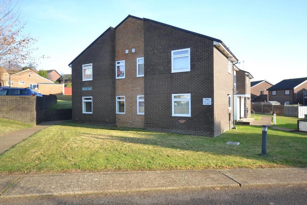
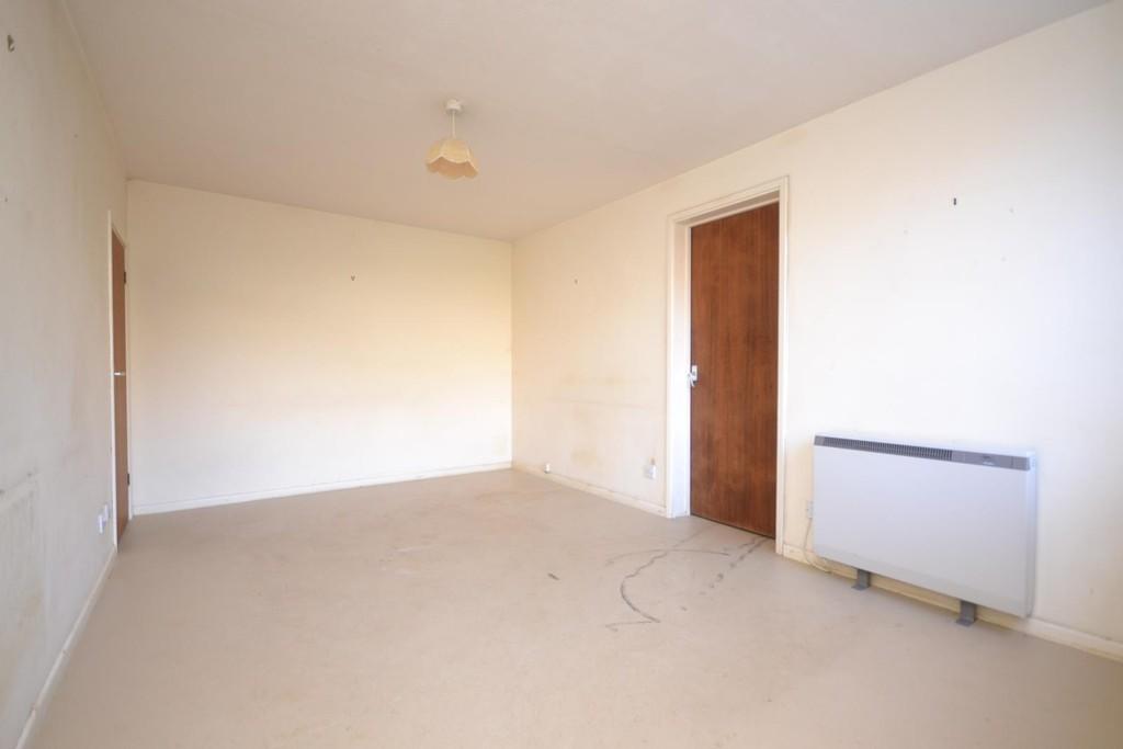
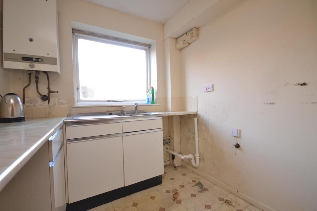
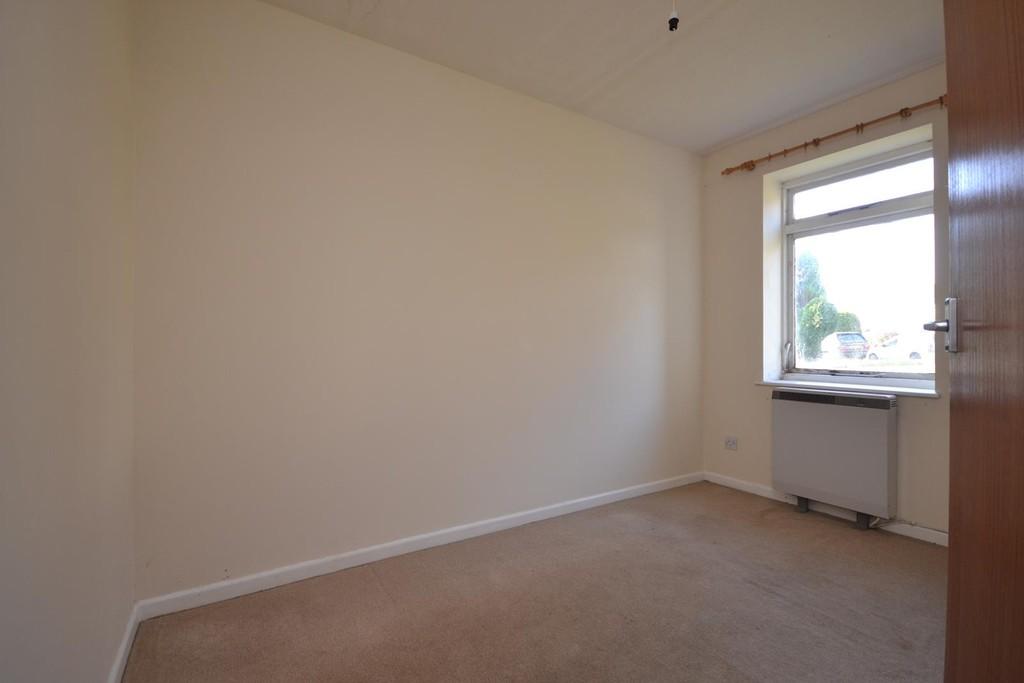
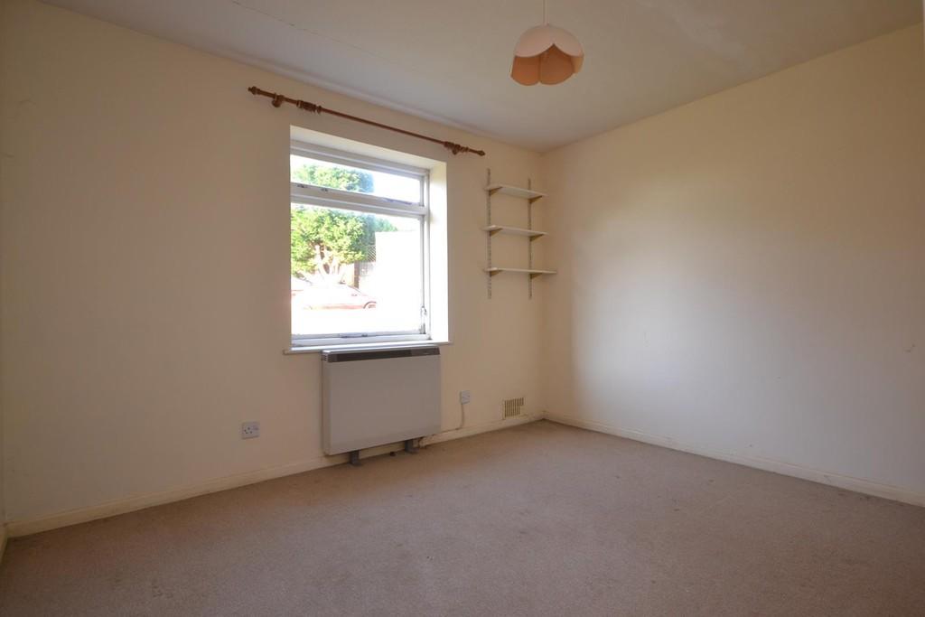
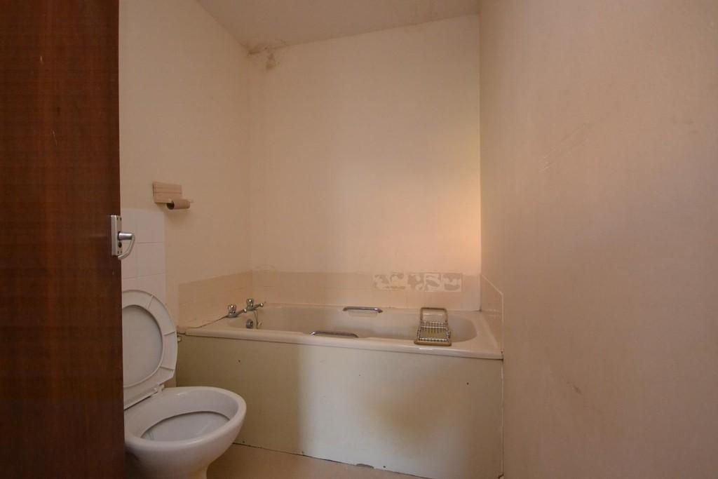
Photo 1 Photo 2 Photo 3 Photo 4 Photo 5 Photo 6
/ 6
Property details
Tenure
LEASEHOLD
Floor area
38 m²
EPC rating
D
Year built
England and Wales: 1976-1982
Last sold
£62,500 May 2017
Price per m²
£1,711/m²
Local average
£143,173 (-54.6%)
Deprivation
Decile 5 (13,795 of 33,755)
Street crime
3 incidents within 1 mile (Mar 2026)
Key features
- RENOVATION REQUIRED!
- CHAIN FREE!!!
- Purpose Built Ground Floor Flat
- 2 Bedrooms
- Private Entrance
- Allocated Parking
Additional details
- Parking
- Allocated
Description
The property is in need of complete renovation and the accommodation comprises 2 bedrooms, lounge, separate kitchen and bathroom. Additionally, the property benefits from a private entrance and an allocated parking space.
The potential to add value makes this an ideal investment opportunity for anyone looking to renovate and sell on or add to their property portfolio. A viewing is recommended to appreciate the full extent of the work required and scope for improvement.
LOUNGE 14' 10" x 9' 10" (4.52m x 3m)
KITCHEN 7' 1" x 5' 0" (2.16m x 1.52m)
BEDROOM 1 11' 1" max x 10' 1" max (3.38m max x 3.07m max)
BEDROOM 2 10' 5" x 6' 10" (3.18m x 2.08m)
BATHROOM
OUTSIDE The property is approached over a communal path leading to the private ground floor entrance. Allocated parking is located adjacent to the property.
HEATING ** Electric heating.
Listed by
Shanklin
Leaders and Romans Group
Reference: 45794427
EPC Rating & Upgrade Cost
Current rating: D
Potential rating: C
Inspection date: 12/01/2017
Current heating cost: £427/year
Potential heating cost: £163/year
Recommendations
- Cavity wall insulation (1,500)
- Floor insulation (solid floor) (6,000)
- Draughtproof single-glazed windows (120)
- Low energy lighting for all fixed outlets (30)
- Change heating to gas condensing boiler (7,000)
- Replace single glazed windows with low-E double glazing (6,500)
Flood risk
Zone: 1
Risk: Low
Job (default Low)
Floorplans
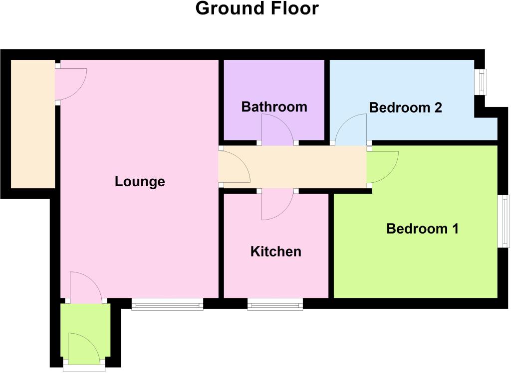
Floorplan 1
EPC Graphs
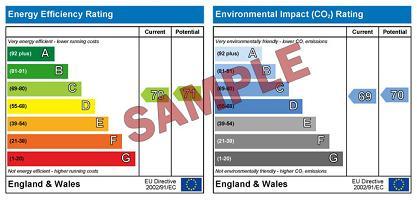
EPC 1
Price history
| Event | Date | Price | % change |
|---|---|---|---|
| Sold | 04/05/2017 (9 years ago) | £62,500 | — |
Source: HM Land Registry Price Paid Data. Crown copyright.
Sold Comparables
Same street and nearby sales within 0.25 miles (last 5 years). Data from Land Registry Price Paid.
| Address | Price | Date | Type |
|---|---|---|---|
| FERNHILL COURT FLAT 4 PARKWAY, APSE HEATH, SANDOWN, ISLE OF WIGHT, PO36 0LW | £85,000 | 05/01/2026 | Flat |
| Same street WINFORD COURT FLAT 6 FOREST WAY, WINFORD, SANDOWN, ISLE OF WIGHT, PO36 0JJ | £131,000 | 12/03/2025 | Flat |
| Same street WINFORD COURT FLAT 15 FOREST WAY, WINFORD, SANDOWN, ISLE OF WIGHT, PO36 0JJ | £140,000 | 06/07/2023 | Flat |
| FERNHILL COURT FLAT 11 PARKWAY, APSE HEATH, SANDOWN, ISLE OF WIGHT, PO36 0LW | £125,000 | 07/03/2023 | Flat |
| 1 THE CHASE, APSE HEATH, SANDOWN, ISLE OF WIGHT, PO36 0PD | £110,000 | 16/09/2022 | Flat |
| Same street WINFORD COURT FLAT 8 FOREST WAY, WINFORD, SANDOWN, ISLE OF WIGHT, PO36 0JJ | £130,000 | 29/04/2022 | Flat |
| FERNHILL COURT FLAT 5 PARKWAY, APSE HEATH, SANDOWN, ISLE OF WIGHT, PO36 0LW | £99,000 | 23/11/2021 | Flat |
| FOREST COURT FLAT 2 FOREST WAY, WINFORD, SANDOWN, ISLE OF WIGHT, PO36 0JL | £94,000 | 30/07/2021 | Flat |
Street average: £133,667 (3 sales)
Area average: £102,600 (5 sales)
Capital growth trend
Land Registry outcode average: last 12 months vs 5y and 10y ago (from sold prices).
House Price Index (HM Land Registry — official index, not sold-price averages): Isle of Wight. Series: Flats and maisonettes. As of February 2026.
Rental Range
Estimated market rent for Isle of Wight. Low = conservative, Realistic = average, Optimistic = best case.
Based on Local Authority from postcode lookup → Isle of Wight.
Location
Address
Forest Way
Nearby
Nearest stations, universities and amenities (distance from property).
| Type | Name | Distance |
|---|---|---|
| Bus stop | Forest Road East | 0.1 miles |
| Bus stop | Winford, Parkway | 0.1 miles |
| Shop | William Hall Independent Funeral Directors | 0.3 miles |
| Shop | Isle of Wight Cheese Co | 0.4 miles |
| Train station | Shanklin | 1.7 miles |
| Train station | Lake | 1.7 miles |
| Hospital | Earl Mountbatten Hospice | 5.1 miles |
| Hospital | Orchard Private Hospital | 5.4 miles |
| University | University of Portsmouth Area | 10.9 miles |
| University | 36-40 Middle Street | 10.9 miles |
Street-level crime
| Category | Count |
|---|---|
| Violence and sexual offences | 2 |
| Criminal damage and arson | 1 |
| Total incidents | 3 |
Within 1 mile during Mar 2026. Source: data.police.uk (England & Wales).
Schools nearby
Nearest open schools with Ofsted ratings (England). Closed schools are not shown. Data from Get Information about Schools and Ofsted.
| Name | Type | Distance | Ofsted |
|---|---|---|---|
| Newchurch Primary School | Primary | 0.9 miles | Good — 8 Sep 2024 |
| Broadlea Primary School | Primary | 1.3 miles | Good — 15 Nov 2021 |
| Gatten and Lake Primary School | Primary | 1.6 miles | Good — 12 Jan 2023 |
| St Blasius Shanklin CofE Primary Academy | Primary | 1.8 miles | Good — 20 Jul 2017 |
| The Bay Church of England School | Other | 1.9 miles | Good — 26 Apr 2023 |
Rental Comparables
Rental listings exist nearby, but none matched the 2-bedroom estimate from EPC for this property.
Rent-driven metrics
Based on Area rent estimate.
- Rent ratio — Monthly rent ÷ purchase price (1% rule). 1%+ = strong, 0.8–1% = okay, <0.8% = weak for cashflow.
- Max investor price — Rent ÷ 0.8%; the price at which rent would be 0.8% of price (Stoke-style target).
- Target investor price — Rent ÷ 1%; the price at which rent would be 1% of price (strong cashflow band).
- Gross yield — Annual rent as % of purchase price (no costs).