64 RADNOR ROAD
BRISTOL, HORFIELD, CITY OF BRISTOL BS7 8QY
£400,000
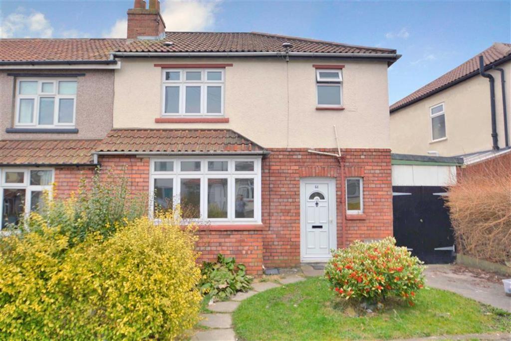
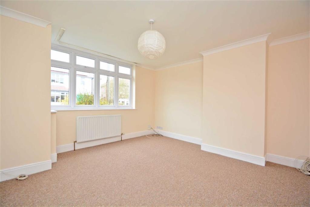
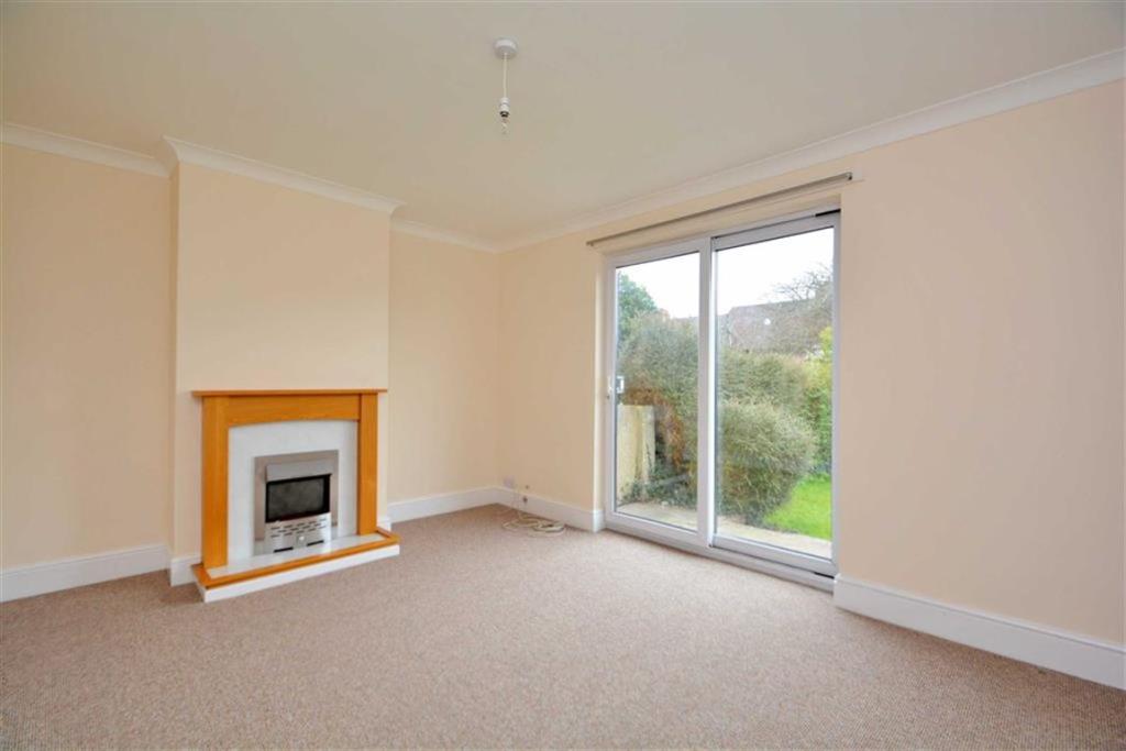

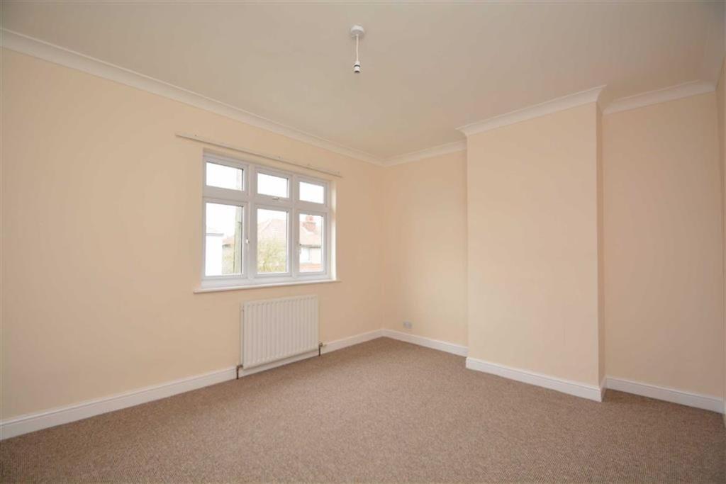
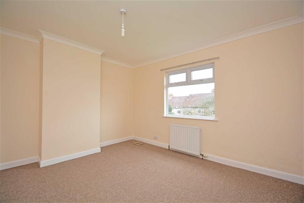
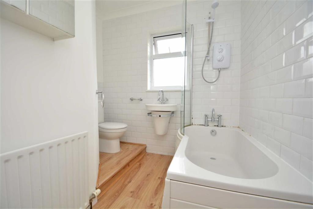
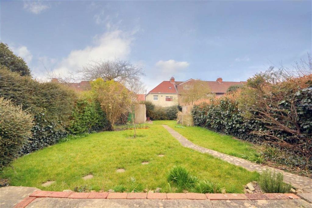
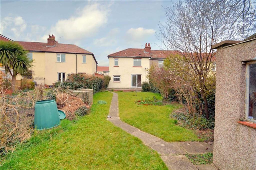
Photo 1 Photo 2 Photo 3 Photo 4 Photo 5 Photo 6 Photo 7 Photo 8 Photo 9
/ 9
Property details
Floor area
89 m²
Last sold
£440,000 Jun 2016
Local average
£496,325 (-19.4%)
Deprivation
Decile 6 (18,509 of 33,755)
Street crime
424 incidents within 1 mile (Apr 2026)
Additional details
- Parking
- Yes
- Garden
- Yes
Description
This well-presented 1930s family home is situated close to Horfield Common and the local cafés, bars and restaurants along the Gloucester Road.
You enter the property into a wide hall with doors leading to the sitting room, dining room, kitchen and stairs leading to the first floor accommodation.
The property briefly comprises bay fronted sitting room, dining room (with double doors leading to the rear garden) and kitchen which is fitted with a range of contemporary units and electric oven and gas hob.
On the first floor are three bedrooms and a family bathroom.
To the rear is a large South Westerly facing garden with paved patio area leading to a large lawn and storage shed to the rear. The lean to garage is also accessed from the rear and is fitted with power sockets.
You may download, store and use the material for your own personal use and research. You may not republish, retransmit, redistribute or otherwise make the material available to any party or make the same available on any website, online service or bulletin board of your own or of any other party or make the same available in hard copy or in any other media without the website owner's express prior written consent. The website owner's copyright must remain on all reproductions of material taken from this website.
Listed by
Bishopston
Kendall Harper
Reference: 40926471
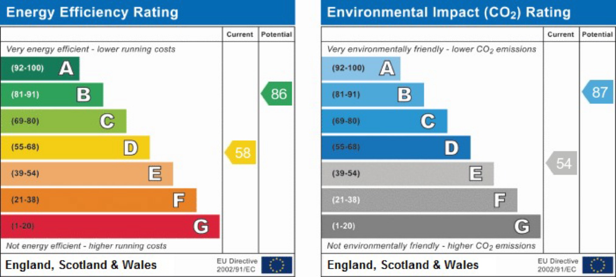
EPC Rating & Upgrade Cost
Fetching EPC data… Refresh this page in a moment.
Flood risk
Zone: 1
Risk: Low
Job (default Low)
Floorplans
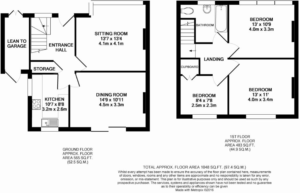
Floorplan 1
EPC Graphs
EPC 1
Price history
307% since 2000
| Event | Date | Price | % change |
|---|---|---|---|
| Sold | 24/06/2016 (9 years ago) | £440,000 | +307.4% |
| Sold | 17/11/2000 (25 years ago) | £108,000 | — |
Source: HM Land Registry Price Paid Data. Crown copyright.
Sold Comparables
Same street and nearby sales within 0.25 miles (last 5 years). Data from Land Registry Price Paid.
| Address | Price | Date | Type |
|---|---|---|---|
| 19 BEECH ROAD, BRISTOL, CITY OF BRISTOL, BS7 8RP | £123,000 | 19/12/2025 | Terraced |
| 42 OAK ROAD, BRISTOL, CITY OF BRISTOL, BS7 8RY | £460,000 | 18/12/2025 | Terraced |
| 38 HARWOOD SQUARE, BRISTOL, CITY OF BRISTOL, BS7 8QN | £532,500 | 17/12/2025 | Terraced |
| 36 HARWOOD SQUARE, BRISTOL, CITY OF BRISTOL, BS7 8QN | £555,555 | 16/12/2025 | Terraced |
| 52 THORNLEIGH ROAD, BRISTOL, CITY OF BRISTOL, BS7 8PJ | £703,000 | 11/12/2025 | Terraced |
| 66 MAPLE ROAD, BRISTOL, CITY OF BRISTOL, BS7 8RG | £500,000 | 07/11/2025 | Terraced |
| 40 OAK ROAD, BRISTOL, CITY OF BRISTOL, BS7 8RY | £487,500 | 16/01/2025 | Terraced |
| 262 GLOUCESTER ROAD, HORFIELD, BRISTOL, CITY OF BRISTOL, BS7 8PB | £275,000 | 15/11/2024 | Terraced |
| 8 CAMBRIDGE ROAD, BRISTOL, CITY OF BRISTOL, BS7 8PR | £364,000 | 19/12/2023 | Terraced |
| 104 RADNOR ROAD, HORFIELD, BRISTOL, CITY OF BRISTOL, BS7 8QZ | £722,500 | 15/12/2023 | Terraced |
| 320 GLOUCESTER ROAD, HORFIELD, BRISTOL, CITY OF BRISTOL, BS7 8TJ | £350,000 | 29/11/2023 | Terraced |
| 49 MONK ROAD, BRISTOL, CITY OF BRISTOL, BS7 8NE | £650,000 | 31/08/2023 | Terraced |
| Same street 22 RADNOR ROAD, HORFIELD, BRISTOL, CITY OF BRISTOL, BS7 8QY | £595,000 | 25/07/2023 | Terraced |
| 48 OAK ROAD, BRISTOL, CITY OF BRISTOL, BS7 8RZ | £350,000 | 04/05/2023 | Terraced |
| 31 MANOR ROAD, BISHOPSTON, BRISTOL, CITY OF BRISTOL, BS7 8PZ | £540,000 | 28/04/2023 | Terraced |
| 4 CLEVEDON ROAD, BRISTOL, CITY OF BRISTOL, BS7 8PT | £542,500 | 23/02/2023 | Terraced |
| 79 OAK ROAD, BRISTOL, CITY OF BRISTOL, BS7 8RZ | £455,000 | 21/12/2022 | Terraced |
| 19 OAK ROAD, BRISTOL, CITY OF BRISTOL, BS7 8RY | £440,000 | 19/12/2022 | Terraced |
| 81 RADNOR ROAD, HORFIELD, BRISTOL, CITY OF BRISTOL, BS7 8RA | £511,500 | 08/12/2022 | Terraced |
| 33 MANOR ROAD, BISHOPSTON, BRISTOL, CITY OF BRISTOL, BS7 8PZ | £675,000 | 30/11/2022 | Terraced |
| 15 BELOE ROAD, BRISTOL, CITY OF BRISTOL, BS7 8RB | £686,000 | 25/11/2022 | Terraced |
| Same street 54 RADNOR ROAD, HORFIELD, BRISTOL, CITY OF BRISTOL, BS7 8QY | £575,000 | 08/04/2022 | Terraced |
| Same street 18 RADNOR ROAD, HORFIELD, BRISTOL, CITY OF BRISTOL, BS7 8QY | £505,000 | 23/12/2021 | Semi-detached |
| Same street 30 RADNOR ROAD, HORFIELD, BRISTOL, CITY OF BRISTOL, BS7 8QY | £570,000 | 06/08/2021 | Semi-detached |
Street average: £561,250 (4 sales)
Area average: £496,153 (20 sales)
Capital growth trend
Land Registry outcode average: last 12 months vs 5y and 10y ago (from sold prices).
House Price Index (HM Land Registry — official index, not sold-price averages): City of Bristol. Series: Terraced. As of March 2026.
Rental Range
Estimated market rent for Bristol, City of. Low = conservative, Realistic = average, Optimistic = best case.
Based on Local Authority from postcode lookup → Bristol, City of.
LHA (30th percentile) floor for Bristol: £1,296/mo (Apr 2025 – Mar 2026)
Location
Nearby
Nearest stations, universities and amenities (distance from property).
| Type | Name | Distance |
|---|---|---|
| Shop | D&S Autos | 0.2 miles |
| Shop | Starphone | 0.2 miles |
| Bus stop | Nevil Road | 0.2 miles |
| Bus stop | Ashley Down Road | 0.2 miles |
| University | City of Bristol College Ashley Down Centre | 0.6 miles |
| Train station | Ashley Down | 0.7 miles |
| University | University of the West of England | 0.7 miles |
| Train station | Montpelier | 1.0 miles |
| Hospital | Southmead Hospital | 1.0 miles |
| Hospital | Priory Hospital Bristol | 1.1 miles |
Street-level crime
| Category | Count |
|---|---|
| Violence and sexual offences | 127 |
| Shoplifting | 87 |
| Anti-social behaviour | 40 |
| Vehicle crime | 32 |
| Other theft | 31 |
| Criminal damage and arson | 27 |
| Burglary | 24 |
| Public order | 24 |
| Other crime | 11 |
| Robbery | 8 |
| Bicycle theft | 7 |
| Drugs | 3 |
| Possession of weapons | 2 |
| Theft from the person | 1 |
| Total incidents | 424 |
Within 1 mile during Apr 2026. Source: data.police.uk (England & Wales).
Schools nearby
Nearest open schools with Ofsted ratings (England). Closed schools are not shown. Data from Get Information about Schools and Ofsted.
| Name | Type | Distance | Ofsted |
|---|---|---|---|
| Bishop Road Primary School | Primary | 0.2 miles | Outstanding — 12 Dec 2023 |
| Ashley Down Primary School | Primary | 0.3 miles | Good — 28 Feb 2019 |
| St Bonaventure's Catholic Primary School | Primary | 0.4 miles | Good — 4 Jul 2013 |
| Brunel Field Primary School | Primary | 0.5 miles | Good — 15 Jan 2024 |
| Claremont School | Other | 0.5 miles | Good — 20 Mar 2013 |
Rental Comparables
Rental listings exist nearby, but none matched the 3-bedroom count for this property.
Rent-driven metrics
Based on Area rent estimate.
- Rent ratio — Monthly rent ÷ purchase price (1% rule). 1%+ = strong, 0.8–1% = okay, <0.8% = weak for cashflow.
- Max investor price — Rent ÷ 0.8%; the price at which rent would be 0.8% of price (Stoke-style target).
- Target investor price — Rent ÷ 1%; the price at which rent would be 1% of price (strong cashflow band).
- Gross yield — Annual rent as % of purchase price (no costs).