82 WIMBORNE AVENUE
HAYES, GREATER LONDON UB4 0HH
£1,000 pcm
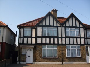
Photo 1
/ 1
Property details
Deprivation
Decile 3 (9,760 of 33,755)
Street crime
536 incidents within 1 mile (Mar 2026)
Key features
- Semi Detached House
- Three Bedrooms
- Two Reception Rooms
- Gas Central Heating
- Double Glazed Windows
- Modern Fitted Kitchen/ Bathroom
- Close to Uxbridge Road and A312
- Off Street Parking For Two Cars
- Would Suit Family
- Available NOW
Additional details
- Parking
- Yes
Description
Listed by
Hertfordshire
SM Properties
Reference: 19594724
EPC Rating & Upgrade Cost
Fetching EPC data… Refresh this page in a moment.
Flood risk
Zone: 1
Risk: Low
Job (default Low)
FENSA Certificates
This property has 1 FENSA certificate(s) on record, indicating window/door installations by FENSA-approved installers.
FENSA Certificate #2565055
Property Details
Street: 82 Wimborne Avenue
Town: HAYES
Postcode: UB4 0HH
Installation Details
Items: 1 window
Certificate Issued: 21/03/2005
Work Completed: 28/01/2005
This certificate data was retrieved from FENSA's database
What is FENSA? FENSA (Fenestration Self-Assessment Scheme) is a government-authorised scheme that monitors building regulation compliance for replacement windows and doors. Certificates indicate that work was completed by FENSA-approved installers.
Rental Range
Estimated market rent for Hillingdon. Low = conservative, Realistic = average, Optimistic = best case.
Based on Local Authority from postcode lookup → Hillingdon.
LHA (30th percentile) floor for Outer West London: £1,471/mo (Apr 2025 – Mar 2026)
Location
Nearby
Nearest stations, universities and amenities (distance from property).
| Type | Name | Distance |
|---|---|---|
| Bus stop | Hayes / The Grapes | 0.1 miles |
| Shop | JD Sports | 0.2 miles |
| Shop | Unknown | 0.2 miles |
| Hospital | The Broadway Health Centre | 1.2 miles |
| Train station | Hayes and Harlington | 1.3 miles |
| Train station | Southall | 1.5 miles |
| Hospital | Hillingdon Hospital | 2.5 miles |
| University | Faraday Complex | 3.0 miles |
| University | Clifton Halls | 3.0 miles |
Street-level crime
| Category | Count |
|---|---|
| Violence and sexual offences | 143 |
| Anti-social behaviour | 118 |
| Shoplifting | 64 |
| Vehicle crime | 45 |
| Other theft | 36 |
| Criminal damage and arson | 30 |
| Drugs | 24 |
| Burglary | 20 |
| Public order | 17 |
| Theft from the person | 17 |
| Other crime | 9 |
| Robbery | 9 |
| Bicycle theft | 2 |
| Possession of weapons | 2 |
| Total incidents | 536 |
Within 1 mile during Mar 2026. Source: data.police.uk (England & Wales).
Schools nearby
Nearest open schools with Ofsted ratings (England). Closed schools are not shown. Data from Get Information about Schools and Ofsted.
| Name | Type | Distance | Ofsted |
|---|---|---|---|
| Yeading Infant and Nursery School | Primary | 0.3 miles | Outstanding — 29 Apr 2019 |
| Yeading Junior School | Primary | 0.3 miles | Good — 11 Jul 2023 |
| Dr Triplett's CofE Primary School | Primary | 0.6 miles | Good — 20 Jul 2016 |
| Minet Junior School | Primary | 0.6 miles | Good — 12 Oct 2015 |
| Minet Infant and Nursery School | Primary | 0.6 miles | Good — 13 Jan 2014 |
Rental Comparables
Rental listings exist nearby, but none matched the 3-bedroom count for this property.