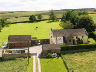
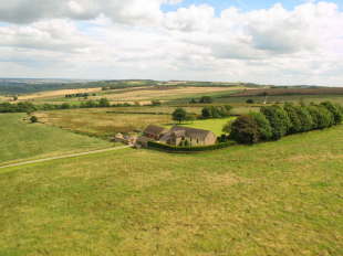
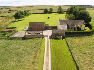
Syda House
CHESTERFIELD, UPPER LOADS, DERBYSHIRE S42 7HP
Property details
Last sold
£850,000 Nov 2007
Local average
£364,873 (+133%)
Deprivation
Decile 7 (21,438 of 33,755)
Street crime
0 incidents within 1 mile (Apr 2026)
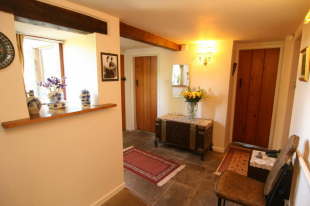
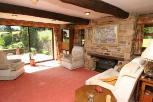
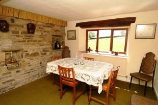
Key features
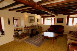
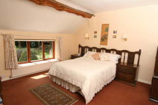
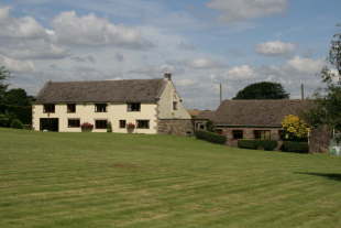
- 4 Bed Renovated Farmhouse
- 3 Reception Rooms
- 2 Bathrooms Plus Extra Wc
- Oil Fired Central Heating
- Double Glazing
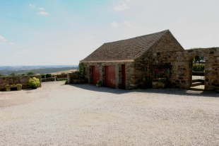
- Range Of Outbuildings
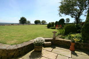
- Beautiful Grounds
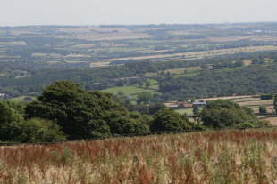
- Breathtaking Views
Description
Listed by
Blundells Fine & country - Sheffield
Countrywide UK Sales - Connells
Reference: 16543898
EPC ratings on this postcode
We don't have a matched EPC for this property yet. Below are efficiency scores and details for other addresses on this postcode.
| Address | Current | Potential | Floor area | Age band | Type |
|---|---|---|---|---|---|
| Loads Head Farm, Upper Loads, Holymoorside, CHESTERFIELD | 28 | 77 | 158 m² | England and Wales: before 1900 | Detached |
| Upper Loads Farm, Upper Loads, Holymoorside, CHESTERFIELD | 33 | 81 | 231 m² | England and Wales: before 1900 | Detached |
Flood risk
Zone: 1
Risk: Low
Job (default Low)
Price history
| Event | Date | Price | % change |
|---|---|---|---|
| Sold | 02/11/2007 (18 years ago) | £850,000 | — |
Source: HM Land Registry Price Paid Data. Crown copyright.
Sold Comparables
Same street and nearby sales within 0.25 miles (last 5 years). Data from Land Registry Price Paid.
| Address | Price | Date | Type |
|---|---|---|---|
| 22 THE MEADOWS, ASHGATE, CHESTERFIELD, DERBYSHIRE, S42 7JY | £330,000 | 07/01/2026 | Detached |
| 5 WHEATHILL CLOSE, ASHGATE, CHESTERFIELD, DERBYSHIRE, S42 7JZ | £282,000 | 19/12/2025 | Detached |
| 6 ST JOHNS CLOSE, WALTON, CHESTERFIELD, NORTH EAST DERBYSHIRE, DERBYSHIRE, S42 7HH | £585,000 | 12/12/2025 | Detached |
| 23 WHEATHILL CLOSE, ASHGATE, CHESTERFIELD, DERBYSHIRE, S42 7JZ | £225,000 | 28/11/2025 | Detached |
| AMBRON HOUSE INGMANTHORPE, CUTTHORPE, CHESTERFIELD, NORTH EAST DERBYSHIRE, DERBYSHIRE, S42 7AX | £1,375,000 | 26/08/2025 | Detached |
| 107 LOADS ROAD, HOLYMOORSIDE, CHESTERFIELD, NORTH EAST DERBYSHIRE, DERBYSHIRE, S42 7HW | £627,000 | 18/07/2025 | Detached |
| 7 FOXCOTE WAY, WALTON, CHESTERFIELD, DERBYSHIRE, S42 7NP | £415,000 | 20/03/2025 | Detached |
| KILBIRNIE MATLOCK ROAD, WALTON, CHESTERFIELD, DERBYSHIRE, S42 7LD | £960,000 | 05/02/2025 | Detached |
| 46 MATLOCK ROAD, WALTON, CHESTERFIELD, DERBYSHIRE, S42 7LD | £587,000 | 09/08/2024 | Detached |
| FAIRVIEW MAIN ROAD, WADSHELF, CHESTERFIELD, NORTH EAST DERBYSHIRE, DERBYSHIRE, S42 7BX | £255,000 | 18/12/2023 | Detached |
| 12 CORNFIELD CLOSE, ASHGATE, CHESTERFIELD, DERBYSHIRE, S42 7JU | £230,000 | 18/12/2023 | Detached |
| 21 WHEATHILL CLOSE, ASHGATE, CHESTERFIELD, DERBYSHIRE, S42 7JZ | £310,000 | 01/12/2023 | Detached |
| 8 FARNDALE AVENUE, WALTON, CHESTERFIELD, DERBYSHIRE, S42 7NL | £180,000 | 29/11/2023 | Detached |
| 167 WALTON BACK LANE, WALTON, CHESTERFIELD, DERBYSHIRE, S42 7LT | £800,000 | 27/10/2023 | Detached |
| 31 ACORN RIDGE, WALTON, CHESTERFIELD, NORTH EAST DERBYSHIRE, DERBYSHIRE, S42 7HF | £365,000 | 24/10/2023 | Detached |
| ELOISE HOLYMOOR ROAD, HOLYMOORSIDE, CHESTERFIELD, NORTH EAST DERBYSHIRE, DERBYSHIRE, S42 7DS | £650,000 | 05/10/2023 | Detached |
| 16 BOWLAND DRIVE, WALTON, CHESTERFIELD, DERBYSHIRE, S42 7LZ | £337,500 | 29/09/2023 | Detached |
| 28 MAIN ROAD, CUTTHORPE, CHESTERFIELD, NORTH EAST DERBYSHIRE, DERBYSHIRE, S42 7AJ | £390,000 | 29/09/2023 | Detached |
| 45 SOMERSBY AVENUE, WALTON, CHESTERFIELD, DERBYSHIRE, S42 7LY | £340,000 | 05/04/2023 | Detached |
| 51 SOMERSBY AVENUE, WALTON, CHESTERFIELD, DERBYSHIRE, S42 7LY | £255,000 | 22/02/2023 | Detached |
Area average: £474,925 (20 sales)
Capital growth trend
Land Registry outcode average: last 12 months vs 5y and 10y ago (from sold prices).
House Price Index (HM Land Registry — official index, not sold-price averages): North East Derbyshire. Series: Detached. As of March 2026.
Rental Range
Estimated market rent for North East Derbyshire. Low = conservative, Realistic = average, Optimistic = best case.
Based on Local Authority from postcode lookup → North East Derbyshire.
LHA (30th percentile) floor for Chesterfield: £848/mo (Apr 2025 – Mar 2026)
Location
Nearby
Nearest stations, universities and amenities (distance from property).
| Type | Name | Distance |
|---|---|---|
| Bus stop | Baslow Road | 0.9 miles |
| Shop | Unknown | 1.7 miles |
| Shop | Londis | 2.6 miles |
| Train station | Chesterfield | 4.6 miles |
| Train station | Unknown | 4.7 miles |
| Hospital | Whitworth Hospital | 5.3 miles |
| Hospital | Clay Cross Hospital | 6.3 miles |
| University | University of Derby | 10.7 miles |
| University | Unknown | 11.1 miles |
Street-level crime
| Category | Count |
|---|---|
| Total incidents | 0 |
Within 1 mile during Apr 2026. Source: data.police.uk (England & Wales).
Schools nearby
Nearest open schools with Ofsted ratings (England). Closed schools are not shown. Data from Get Information about Schools and Ofsted.
| Name | Type | Distance | Ofsted |
|---|---|---|---|
| Wigley Primary School | Primary | 1.3 miles | Good — 28 Sep 2011 |
| Walton Holymoorside Primary School | Primary | 1.7 miles | Good — 13 Dec 2023 |
| Brookfield Community School | Secondary | 2.5 miles | Good — 14 Jun 2023 |
| Westfield Infant School | Primary | 2.7 miles | Good — 15 Feb 2024 |
| Cutthorpe Primary School | Primary | 2.7 miles | Good — 12 Dec 2022 |
Rental Comparables
Loading rental comparables for this postcode. Refresh in a few minutes.
Rent-driven metrics
Based on Area rent estimate.
- Rent ratio — Monthly rent ÷ purchase price (1% rule). 1%+ = strong, 0.8–1% = okay, <0.8% = weak for cashflow.
- Max investor price — Rent ÷ 0.8%; the price at which rent would be 0.8% of price (Stoke-style target).
- Target investor price — Rent ÷ 1%; the price at which rent would be 1% of price (strong cashflow band).
- Gross yield — Annual rent as % of purchase price (no costs).
Enter House Number
Enter the house number to help us retrieve more accurate pricing history and property data.
Please log in to submit or correct the house number for this listing.
Log in to continue