76D
NEWLANDS PARK, LONDON, GREATER LONDON SE26 5NE
£1,200 pcm
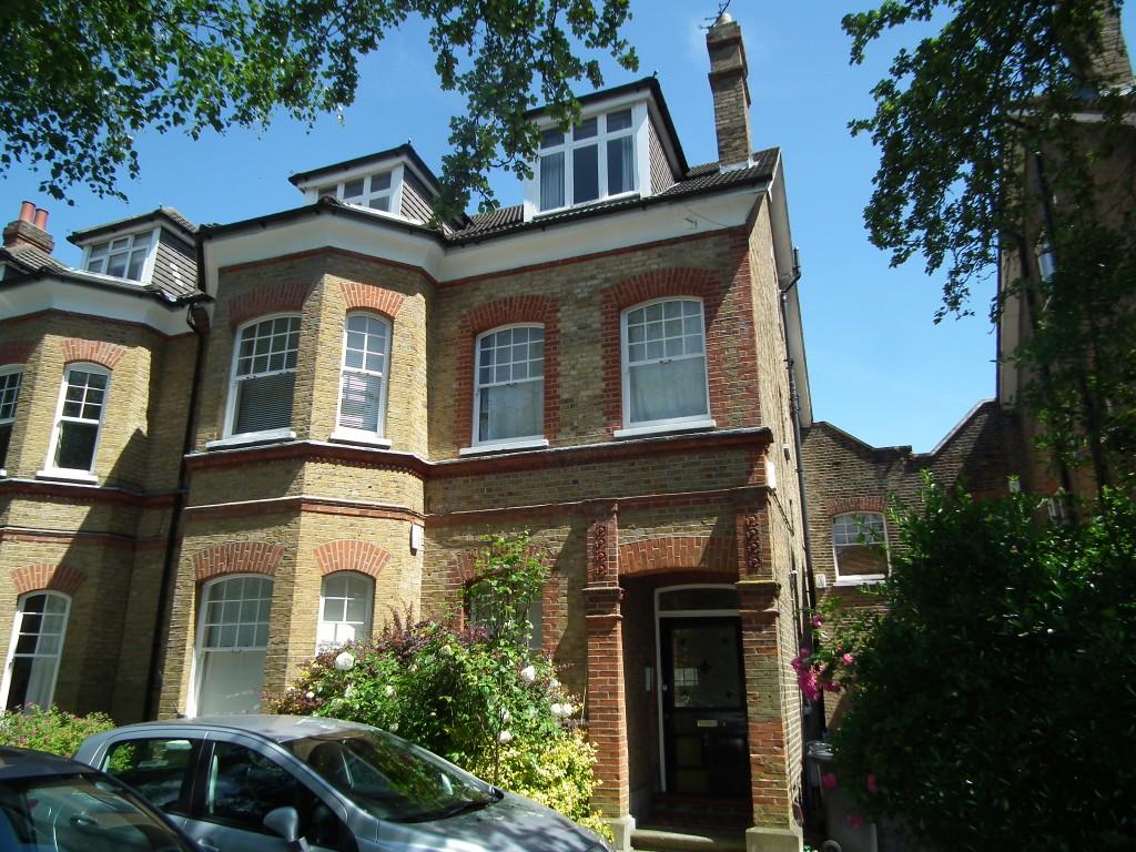
Photo 1
/ 1
Property details
Floor area
80 m²
Deprivation
Decile 5 (13,684 of 33,755)
Street crime
486 incidents within 1 mile (Apr 2026)
Description
Listed by
Sydenham
UniPlan
Reference: 19022415
EPC Rating & Upgrade Cost
Fetching EPC data… Refresh this page in a moment.
Flood risk
Zone: 1
Risk: Low
Job (default Low)
FENSA Certificates
This property has 1 FENSA certificate(s) on record, indicating window/door installations by FENSA-approved installers.
FENSA Certificate #10467362
Property Details
Street: 76d Newlands Park
Town: LONDON
Postcode: SE26 5NE
Installation Details
Items: 6 windows
Certificate Issued: 13/08/2014
Work Completed: 25/07/2014
This certificate data was retrieved from FENSA's database
What is FENSA? FENSA (Fenestration Self-Assessment Scheme) is a government-authorised scheme that monitors building regulation compliance for replacement windows and doors. Certificates indicate that work was completed by FENSA-approved installers.
Rental Range
Estimated market rent for Lewisham. Low = conservative, Realistic = average, Optimistic = best case.
Based on Local Authority from postcode lookup → Lewisham.
LHA (30th percentile) floor for Huntingdon: £793/mo (Apr 2025 – Mar 2026)
Location
Nearby
Nearest stations, universities and amenities (distance from property).
| Type | Name | Distance |
|---|---|---|
| Bus stop | Studland Road | 0.1 miles |
| Shop | Twice Sweet & Wine | 0.2 miles |
| Shop | Tops 'n' Tails Dry Cleaners | 0.2 miles |
| Train station | Penge East | 0.3 miles |
| Train station | Sydenham | 0.3 miles |
| Hospital | Sloane Hospital | 2.3 miles |
| Hospital | British Home & Hospital for Incurables | 2.4 miles |
| University | University of Greenwich | 4.5 miles |
| University | University of Wales Trinity Saint David London Campus | 4.6 miles |
Street-level crime
| Category | Count |
|---|---|
| Violence and sexual offences | 117 |
| Anti-social behaviour | 98 |
| Vehicle crime | 61 |
| Shoplifting | 50 |
| Criminal damage and arson | 39 |
| Other theft | 30 |
| Public order | 25 |
| Robbery | 18 |
| Burglary | 17 |
| Theft from the person | 12 |
| Drugs | 10 |
| Other crime | 4 |
| Possession of weapons | 3 |
| Bicycle theft | 2 |
| Total incidents | 486 |
Within 1 mile during Apr 2026. Source: data.police.uk (England & Wales).
Schools nearby
Nearest open schools with Ofsted ratings (England). Closed schools are not shown. Data from Get Information about Schools and Ofsted.
| Name | Type | Distance | Ofsted |
|---|---|---|---|
| Alexandra Junior School | Primary | 0.3 miles | Good — 6 Dec 2012 |
| Our Lady and St Philip Neri Catholic Primary School | Primary | 0.5 miles | Good — 2 Mar 2015 |
| St Bartholomews's Church of England Primary School | Primary | 0.6 miles | Good — 28 Sep 2023 |
| St Michael's Church of England Primary School | Primary | 0.6 miles | Good — 15 Jun 2011 |
| Harris Primary Academy Crystal Palace | Primary | 0.6 miles | Good — 21 May 2015 |
Rental Comparables
Residential lets from OpenRent and Rightmove for the area (same bedroom count). Use to validate rent estimates. Student lets are excluded.
| Title | Rent | Beds | Distance | As seen on |
|---|---|---|---|---|
| 2 Bed Flat, Bayes Close, SE26 | £1,700/mo | 2 | 0.23 miles | OpenRent |
Average rent: £1,700/mo (1 listing)