197 WELLS ROAD
BRISTOL, BRISTOL, CITY OF BRISTOL BS4 2DB
£365,000
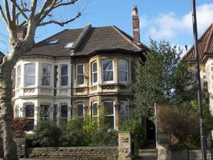
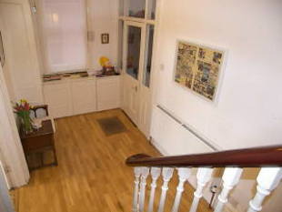
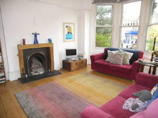
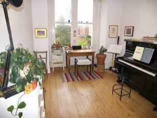
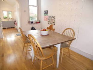
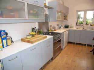
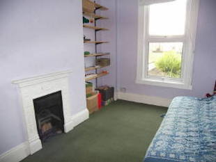
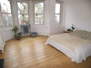
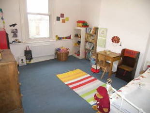
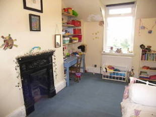
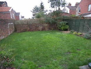
Photo 1 Photo 2 Photo 3 Photo 4 Photo 5 Photo 6 Photo 7 Photo 8 Photo 9 Photo 10 Photo 11
/ 11
Property details
Last sold
£249,000 Jan 2003
Local average
£383,170 (-4.7%)
Deprivation
Decile 6 (18,087 of 33,755)
Street crime
463 incidents within 1 mile (Apr 2026)
Key features
- 4 Double Bedrooms
- 3 Reception Rooms
- Fitted Kitchen
- En-suite Shower Room
- Family Bathroom
- Period Style Features
- Gas C/h + D/glazing
- Westerly Rear Garden
Description
Listed by
Bristol
Greenwoods Property Centre
Reference: 20357417
EPC Rating & Upgrade Cost
Fetching EPC data… Refresh this page in a moment.
Flood risk
Zone: 1
Risk: Low
Job (default Low)
FENSA Certificates
This property has 1 FENSA certificate(s) on record, indicating window/door installations by FENSA-approved installers.
FENSA Certificate #13567025
Property Details
Street: 197 Wells Road
Town: BRISTOL
Postcode: BS4 2DB
Installation Details
Items: 1 window
Certificate Issued: 20/05/2019
Work Completed: 10/05/2019
This certificate data was retrieved from FENSA's database
What is FENSA? FENSA (Fenestration Self-Assessment Scheme) is a government-authorised scheme that monitors building regulation compliance for replacement windows and doors. Certificates indicate that work was completed by FENSA-approved installers.
Price history
| Event | Date | Price | % change |
|---|---|---|---|
| Sold | 16/01/2003 (23 years ago) | £249,000 | — |
Source: HM Land Registry Price Paid Data. Crown copyright.
Sold Comparables
Same street and nearby sales within 0.25 miles (last 5 years). Data from Land Registry Price Paid.
| Address | Price | Date | Type |
|---|---|---|---|
| 19 LILYMEAD AVENUE, BRISTOL, CITY OF BRISTOL, BS4 2BY | £857,000 | 05/04/2023 | Semi-detached |
| 17 BAYHAM ROAD, BRISTOL, CITY OF BRISTOL, BS4 2DY | £730,000 | 20/12/2022 | Semi-detached |
| 4 CROWNDALE ROAD, BRISTOL, CITY OF BRISTOL, BS4 2DZ | £840,000 | 25/11/2022 | Semi-detached |
| 12 LILYMEAD AVENUE, BRISTOL, CITY OF BRISTOL, BS4 2BX | £850,000 | 18/07/2022 | Semi-detached |
| 23 CROWNDALE ROAD, BRISTOL, CITY OF BRISTOL, BS4 2DZ | £635,000 | 17/12/2021 | Semi-detached |
| 19 BAYHAM ROAD, BRISTOL, CITY OF BRISTOL, BS4 2DY | £380,000 | 03/12/2021 | Semi-detached |
| 29 UPPER STREET, BRISTOL, CITY OF BRISTOL, BS4 3BU | £370,000 | 29/09/2021 | Semi-detached |
| 19 BAYHAM ROAD, BRISTOL, CITY OF BRISTOL, BS4 2DY | £320,000 | 30/07/2021 | Semi-detached |
| 34 LILYMEAD AVENUE, BRISTOL, CITY OF BRISTOL, BS4 2BX | £710,000 | 25/06/2021 | Semi-detached |
| 10 PARK STREET, TOTTERDOWN, BRISTOL, CITY OF BRISTOL, BS4 3BL | £303,000 | 11/06/2021 | Semi-detached |
Area average: £599,500 (10 sales)
Capital growth trend
Land Registry outcode average: last 12 months vs 5y and 10y ago (from sold prices).
House Price Index (HM Land Registry — official index, not sold-price averages): City of Bristol. Series: Semi-detached. As of March 2026.
Rental Range
Estimated market rent for Bristol, City of. Low = conservative, Realistic = average, Optimistic = best case.
Based on Local Authority from postcode lookup → Bristol, City of.
LHA (30th percentile) floor for Bristol: £1,845/mo (Apr 2025 – Mar 2026)
Location
Nearby
Nearest stations, universities and amenities (distance from property).
| Type | Name | Distance |
|---|---|---|
| Bus stop | Brecknock Road | 0.0 miles |
| Shop | Londis | 0.1 miles |
| Shop | Hang It Picture Framing | 0.1 miles |
| Train station | Bristol Temple Meads | 0.7 miles |
| University | Bristol Digital Futures Institute | 0.8 miles |
| Train station | Bedminster | 0.9 miles |
| University | dBs Institute Bristol Campus | 1.1 miles |
| Hospital | South West Regional Laboratories | 1.8 miles |
| Hospital | Spire Bristol | 2.9 miles |
Street-level crime
| Category | Count |
|---|---|
| Violence and sexual offences | 174 |
| Anti-social behaviour | 69 |
| Criminal damage and arson | 48 |
| Other theft | 39 |
| Public order | 33 |
| Vehicle crime | 28 |
| Burglary | 20 |
| Shoplifting | 19 |
| Robbery | 9 |
| Other crime | 8 |
| Drugs | 7 |
| Bicycle theft | 4 |
| Possession of weapons | 3 |
| Theft from the person | 2 |
| Total incidents | 463 |
Within 1 mile during Apr 2026. Source: data.police.uk (England & Wales).
Schools nearby
Nearest open schools with Ofsted ratings (England). Closed schools are not shown. Data from Get Information about Schools and Ofsted.
| Name | Type | Distance | Ofsted |
|---|---|---|---|
| Hillcrest Primary School | Primary | 0.1 miles | Good — 21 Jul 2016 |
| Cleve House School | Other | 0.3 miles | — (No rating) |
| Knowle Park Primary School | Primary | 0.6 miles | Good — 7 Sep 2015 |
| St Philips Marsh Nursery School and Barton Hill Childrens Centre/Cashmore Early Years Centre | Nursery | 0.6 miles | Good — 17 Oct 2013 |
| Oasis Academy Temple Quarter | Secondary | 0.6 miles | — (No rating) |
Rental Comparables
Loading rental comparables for this postcode. Refresh in a few minutes.
Rent-driven metrics
Based on Area rent estimate.
- Rent ratio — Monthly rent ÷ purchase price (1% rule). 1%+ = strong, 0.8–1% = okay, <0.8% = weak for cashflow.
- Max investor price — Rent ÷ 0.8%; the price at which rent would be 0.8% of price (Stoke-style target).
- Target investor price — Rent ÷ 1%; the price at which rent would be 1% of price (strong cashflow band).
- Gross yield — Annual rent as % of purchase price (no costs).