4 GIBSIDE COURT
GATESHEAD, GATESHEAD, TYNE AND WEAR NE11 9PT
£750 pcm
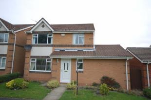
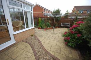
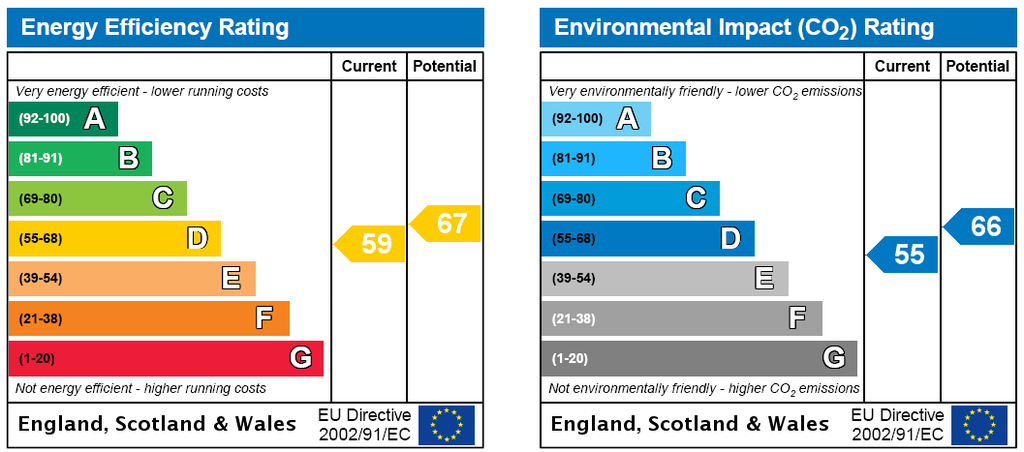
Photo 1 Photo 2 EPC
/ 3
Property details
Floor area
89 m²
EPC rating
E
Year built
England and Wales: 1983-1990
Deprivation
Decile 9 (27,972 of 33,755)
Street crime
74 incidents within 1 mile (Apr 2026)
Key features
- Detached
- Three Bedrooms
- En-suite
- Conservatory
- Furnished
- Gardens
- Sought After Location
Additional details
- Parking
- Yes
- Garden
- Yes
Description
Listed by
Whickham - Lettings
Sarah Mains Residential Sales
Reference: 26369347
EPC Rating & Upgrade Cost
Current rating: E
Potential rating: B
Inspection date: 15/12/2013
Expiry date: 14/12/2023 (expired)
Est. upgrade cost to C: £21,500
Recommendations
- Cavity wall insulation (£500 - £1,500)
- Floor insulation (£800 - £1,200)
- Upgrade heating controls (£350 - £450)
- Replace boiler with new condensing boiler (£2,200 - £3,000)
- Solar water heating (£4,000 - £6,000)
- Solar photovoltaic panels, 2.5 kWp (£9,000 - £14,000)
Flood risk
Zone: 1
Risk: Low
Job (default Low)
Rental Range
Estimated market rent for Gateshead. Low = conservative, Realistic = average, Optimistic = best case.
Based on Local Authority from postcode lookup → Gateshead.
LHA (30th percentile) floor for Tyneside: £648/mo (Apr 2025 – Mar 2026)
Location
Nearby
Nearest stations, universities and amenities (distance from property).
| Type | Name | Distance |
|---|---|---|
| Bus stop | Whickham Highway | 0.0 miles |
| Bus stop | Knightside Gardens-Whickham Highway | 0.1 miles |
| Shop | Chics | 0.2 miles |
| Shop | Nationwide Splicing & Rope Services Ltd | 0.2 miles |
| Train station | Dunston | 0.6 miles |
| Train station | MetroCentre | 1.5 miles |
| University | Northumbria University Coach Lane Campus | 5.3 miles |
| Hospital | Ferndene - Children and Young Peoples Inpatient Service | 7.8 miles |
| Hospital | Sunderland Primary care Trust | 7.9 miles |
Street-level crime
| Category | Count |
|---|---|
| Violence and sexual offences | 26 |
| Anti-social behaviour | 18 |
| Criminal damage and arson | 6 |
| Burglary | 5 |
| Other crime | 5 |
| Public order | 5 |
| Vehicle crime | 5 |
| Other theft | 2 |
| Drugs | 1 |
| Shoplifting | 1 |
| Total incidents | 74 |
Within 1 mile during Apr 2026. Source: data.police.uk (England & Wales).
Schools nearby
Nearest open schools with Ofsted ratings (England). Closed schools are not shown. Data from Get Information about Schools and Ofsted.
| Name | Type | Distance | Ofsted |
|---|---|---|---|
| Emmanuel College | Other | 0.2 miles | — (Inspected (no overall grade)) |
| Lobley Hill Primary School | Primary | 0.3 miles | Good — 9 Jun 2015 |
| Dunston Hill Community Primary School | Primary | 0.6 miles | Good — 27 Mar 2013 |
| Kingsmeadow Community School | Secondary | 0.7 miles | Good — 18 Oct 2021 |
| St Philip Neri Catholic Primary School, Dunston | Primary | 0.8 miles | Good — 21 May 2012 |
Rental Comparables
Residential lets from OpenRent and Rightmove for the area (same bedroom count). Use to validate rent estimates. Student lets are excluded.
| Title | Rent | Beds | Distance | As seen on |
|---|---|---|---|---|
| 3 Bed Semi-Detached House, Knightside Gardens, NE11 | £895/mo | 3 | 0.4 miles | OpenRent |
| 3 Bed Flat, Holly Avenue, NE11 | £875/mo | 3 | 0.42 miles | OpenRent |
| 3 Bed Semi-Detached House, Lobley Hill, NE11 | £975/mo | 3 | 0.62 miles | OpenRent |
| 3 Bed Semi-Detached House, The Granary, NE11 | £1,500/mo | 3 | 0.64 miles | OpenRent |
| 3 Bed Terraced House, Derwentwater Road, NE8 | £1,050/mo | 3 | 0.81 miles | OpenRent |
Average rent: £1,059/mo (5 listings)