54 LEAVENTHORPE LANE
BRADFORD, WEST YORKSHIRE BD8 0EF
£550 pcm
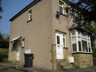
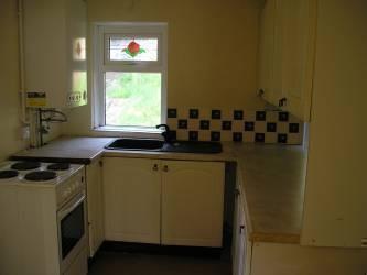
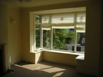
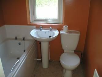
Photo 1 Photo 2 Photo 3 Photo 4
/ 4
Property details
Floor area
69 m²
EPC rating
D
Year built
England and Wales: 1930-1949
Deprivation
Decile 2 (4,430 of 33,755)
Street crime
436 incidents within 1 mile (Apr 2026)
Key features
- **WINTER OFFER** NO APP FEE AND £100 OFF FIRST MONTH RENT
- Lounge
- Dining kitchen
- 2 double bedroom and a single
- Bathroom
- Gardens to front and back
- Off road parking for 3 cars
- Gas central heating
- Double glazing
- Popular residential location
Additional details
- Parking
- Yes
- Garden
- Yes
Description
Listed by
Halifax
Peter David Properties
Reference: 34467839
EPC Rating & Upgrade Cost
Current rating: D
Potential rating: B
Inspection date: 24/09/2018
Expiry date: 23/09/2028
Current heating cost: £589/year
Potential heating cost: £463/year
Recommendations
- Floor insulation (suspended floor) (1,200)
- Upgrade heating controls (450)
- Replace boiler with new condensing boiler (3,000)
- Flue gas heat recovery in conjunction with boiler (900)
- Solar water heating (6,000)
- Solar photovoltaic panels, 2.5 kWp (8,000)
Flood risk
Zone: 1
Risk: Low
Job (default Low)
EPC Graphs

EPC 1
Company ownership
Registered legal owner is a company.
Company: SPANGLES LIMITED
Rental Range
Estimated market rent for Bradford. Low = conservative, Realistic = average, Optimistic = best case.
Based on Local Authority from postcode lookup → Bradford.
LHA (30th percentile) floor for Bradford & South Dales: £633/mo (Apr 2025 – Mar 2026)
Location
Nearby
Nearest stations, universities and amenities (distance from property).
| Type | Name | Distance |
|---|---|---|
| Bus stop | Thornton Road Leaventhorpe Lane | 0.1 miles |
| Bus stop | Thornton Road Rhodesway | 0.1 miles |
| Shop | Unknown | 0.3 miles |
| Hospital | Moorlands View | 1.2 miles |
| University | Bradford University School of Management | 2.1 miles |
| Train station | Bradford Forster Square | 2.3 miles |
| Train station | Bradford Interchange | 2.4 miles |
| Hospital | Eccleshill NHS Treatment Centre | 4.5 miles |
| University | University of Bradford Oxenhope Field Site | 7.2 miles |
Street-level crime
| Category | Count |
|---|---|
| Violence and sexual offences | 187 |
| Shoplifting | 42 |
| Vehicle crime | 40 |
| Criminal damage and arson | 39 |
| Public order | 26 |
| Other theft | 25 |
| Burglary | 22 |
| Anti-social behaviour | 20 |
| Drugs | 19 |
| Other crime | 10 |
| Robbery | 3 |
| Bicycle theft | 1 |
| Possession of weapons | 1 |
| Theft from the person | 1 |
| Total incidents | 436 |
Within 1 mile during Apr 2026. Source: data.police.uk (England & Wales).
Schools nearby
Nearest open schools with Ofsted ratings (England). Closed schools are not shown. Data from Get Information about Schools and Ofsted.
| Name | Type | Distance | Ofsted |
|---|---|---|---|
| Crossley Hall Primary School | Primary | 0.5 miles | Good — 26 May 2016 |
| Dixons Allerton Academy | Other | 0.5 miles | Requires improvement — 27 Jun 2024 |
| Beckfoot Thornton | Secondary | 0.6 miles | Good — 15 Oct 2023 |
| St Anthony's Catholic Primary School, A Voluntary Academy | Primary | 0.6 miles | Good — 12 Sep 2013 |
| Lidget Green Primary School | Primary | 0.6 miles | Good — 2 Mar 2015 |
Rental Comparables
Residential lets from OpenRent and Rightmove for the area (same bedroom count). Use to validate rent estimates. Student lets are excluded.
| Title | Rent | Beds | Distance | As seen on |
|---|---|---|---|---|
| 3 Bed End Terrace, Springs Meadow, BD8 | £1,000/mo | 3 | 0.18 miles | OpenRent |
| 3 Bed Terraced House, Godfrey Street, BD8 | £795/mo | 3 | 0.2 miles | OpenRent |
| 3 Bed Semi-Detached House, Templars Way, BD8 | £995/mo | 3 | 0.44 miles | OpenRent |
| 3 Bed Semi-Detached House, Thirkleby Royd, BD14 | £950/mo | 3 | 0.75 miles | OpenRent |
| 3 Bed Semi-Detached House, St Wilfrids Crescent, BD7 | £1,150/mo | 3 | 0.94 miles | OpenRent |
Average rent: £978/mo (5 listings)