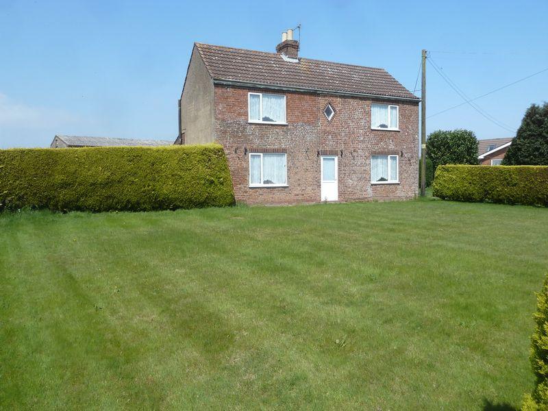
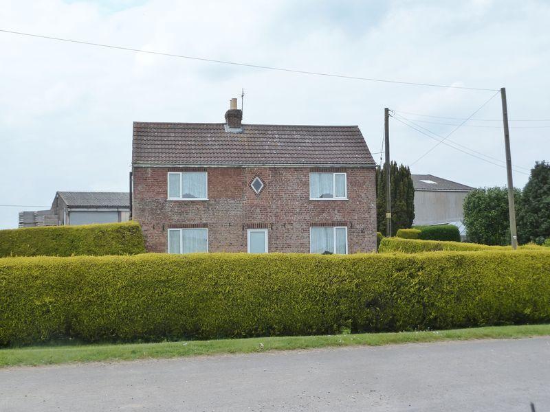
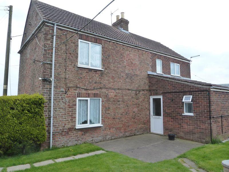
Toft Farm
MAIN ROAD, BOSTON, FRISKNEY, LINCOLNSHIRE PE22 8SE
£160,000
Property details
Last sold
£146,500 Dec 2016
Local average
£563,691 (-71.6%)
Deprivation
Decile 2 (6,213 of 33,755)
Street crime
5 incidents within 1 mile (Mar 2026)
Key features
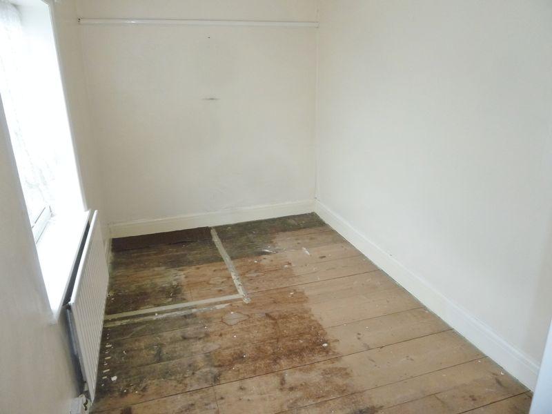
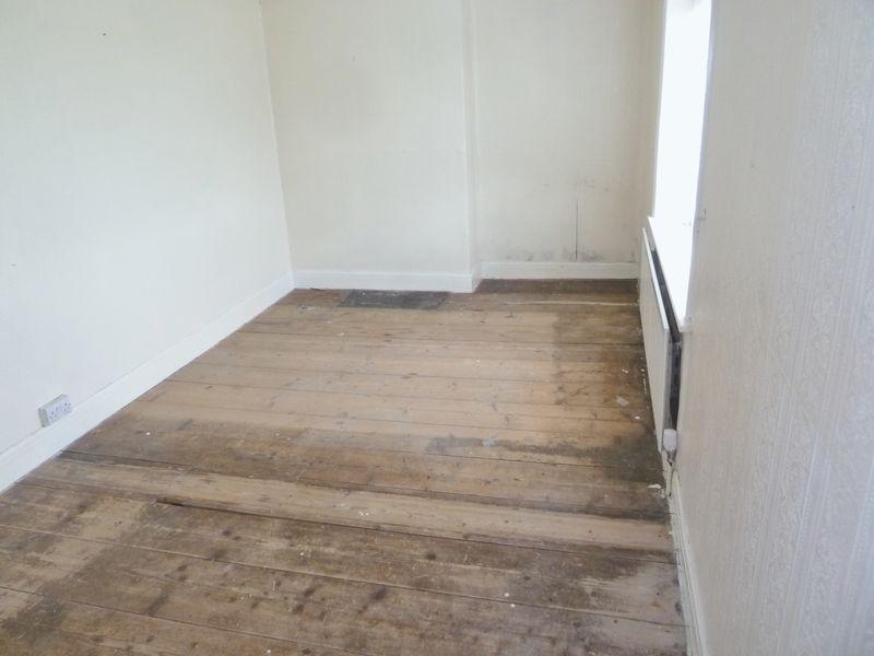
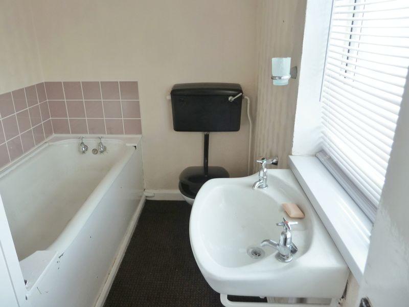
- Detached farm house
- 3 Bedrooms
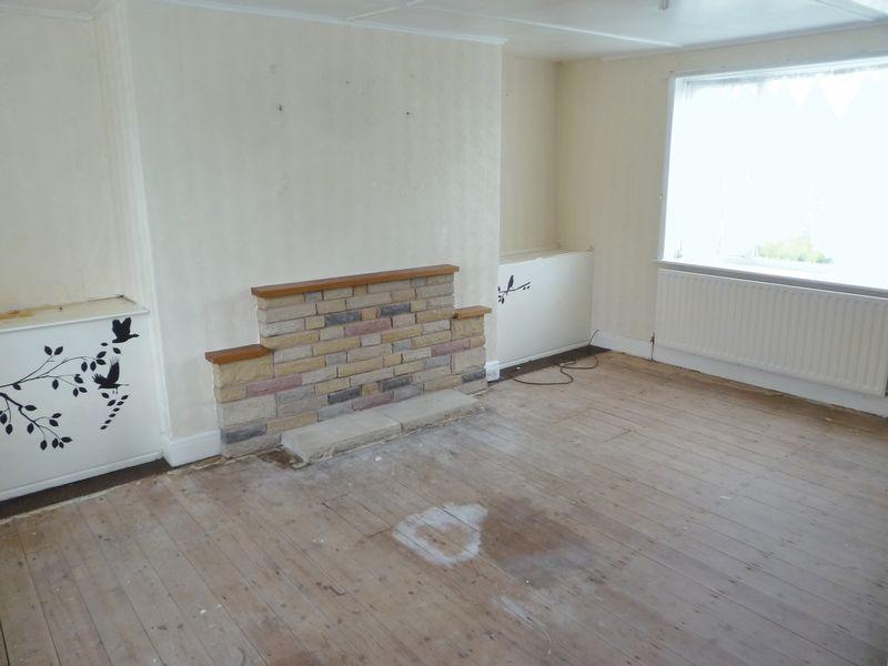
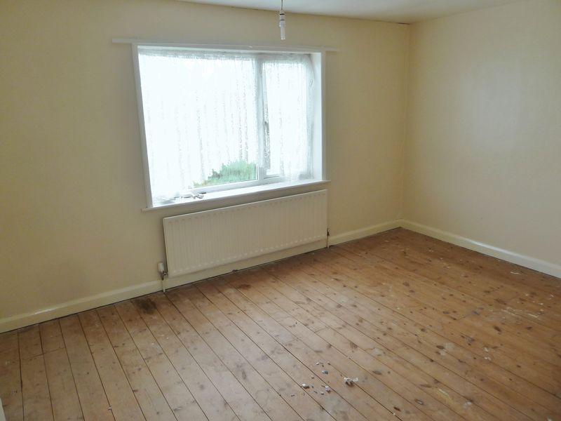
- Living room, sitting room, kitchen
- Good sized garden
- Brick built store shed
- Oil fired central heating & Upvc double glazing
- NO CHAIN
- EPC Rating: E
Additional details
- Garden
- Yes
Description
Listed by
Skegness
Willsons Chartered Surveyors
Reference: 42056541
EPC ratings on this postcode
We don't have a matched EPC for this property yet. Below are efficiency scores and details for other addresses on this postcode.
| Address | Current | Potential | Floor area | Age band | Type |
|---|---|---|---|---|---|
| (Turner), Main Road, Friskney, BOSTON | 36 | 112 | 56 m² | England and Wales: 1900-1929 | Detached |
| 1 Main Road, Friskney, BOSTON | 79 | 88 | 69 m² | England and Wales: 1950-1966 | Detached |
| 1, Main Road, Friskney, BOSTON | 63 | 81 | 77 m² | England and Wales: 1950-1966 | Detached |
| 1, Main Road, Friskney, BOSTON | 45 | 66 | 77 m² | England and Wales: 1950-1966 | Detached |
| 1, Main Road, Friskney, BOSTON | 10 | 80 | 95 m² | England and Wales: before 1900 | Detached |
| 2, Main Road, Friskney, BOSTON | 50 | 69 | 75 m² | England and Wales: 1950-1966 | Detached |
| 2, Main Road, Friskney, BOSTON | 41 | 87 | 77 m² | England and Wales: before 1900 | Detached |
| 3 Main Road, Friskney, BOSTON | 55 | 92 | 101 m² | England and Wales: 1930-1949 | Detached |
| 3, Main Road, Friskney, BOSTON | 63 | 83 | 98 m² | England and Wales: 1950-1966 | Detached |
| Boundary Farm, Main Road, Friskney, BOSTON | 58 | 96 | 144 m² | England and Wales: before 1900 | Detached |
| Bradley House, Main Road, Friskney, BOSTON | 43 | 80 | 77 m² | England and Wales: 1930-1949 | Detached |
| Faulkeners Farm House, Main Road, Friskney, BOSTON | 40 | 76 | 112 m² | England and Wales: before 1900 | Detached |
| Halcyon, Main Road, Friskney, BOSTON | 48 | 97 | 89 m² | England and Wales: 1930-1949 | Detached |
| Heather Cottage, Main Road, Friskney, BOSTON | 21 | 61 | 57 m² | England and Wales: 1950-1966 | Detached |
| Holme Lea, Main Road, Friskney, BOSTON | 81 | 118 | 63 m² | England and Wales: 1930-1949 | Detached |
Flood risk
Zone: 1
Risk: Low
Job (default Low)
Floorplans
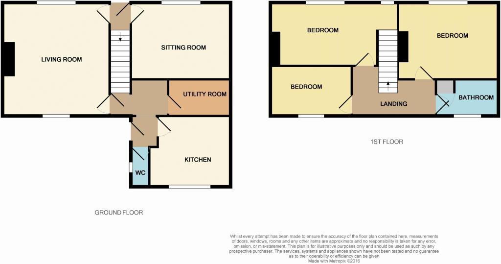
Floorplan 1
EPC Graphs

Energy Perform...
Price history
| Event | Date | Price | % change |
|---|---|---|---|
| Sold | 20/12/2016 (9 years ago) | £146,500 | — |
Source: HM Land Registry Price Paid Data. Crown copyright.
Sold Comparables
Same street and nearby sales within 0.25 miles (last 5 years). Data from Land Registry Price Paid.
| Address | Price | Date | Type |
|---|---|---|---|
| FANTHORPE HOUSE CHURCH ROAD, STICKFORD, BOSTON, EAST LINDSEY, LINCOLNSHIRE, PE22 8EP | £325,000 | 18/12/2025 | Detached |
| WISTERIA CHURCH ROAD, FRISKNEY, BOSTON, EAST LINDSEY, LINCOLNSHIRE, PE22 8RD | £230,000 | 15/12/2025 | Detached |
| PANTILES 1 FIELD LANE, FRISKNEY, BOSTON, EAST LINDSEY, LINCOLNSHIRE, PE22 8RN | £307,000 | 11/12/2025 | Detached |
| WELLINGTON HOUSE FOLD HILL, FRISKNEY, BOSTON, EAST LINDSEY, LINCOLNSHIRE, PE22 8RG | £360,000 | 09/12/2025 | Detached |
| CONISTON HORBLING LANE, STICKNEY, BOSTON, EAST LINDSEY, LINCOLNSHIRE, PE22 8DG | £170,000 | 02/12/2025 | Detached |
| WHITE HOUSE FARM LOW LANE, FRISKNEY, BOSTON, EAST LINDSEY, LINCOLNSHIRE, PE22 8QR | £11,821,327 | 24/11/2025 | Detached |
| MILLWAY 2 FIELD LANE, FRISKNEY, BOSTON, EAST LINDSEY, LINCOLNSHIRE, PE22 8RH | £225,000 | 24/11/2025 | Detached |
| 60 HORBLING LANE, STICKNEY, BOSTON, EAST LINDSEY, LINCOLNSHIRE, PE22 8DQ | £320,000 | 07/11/2025 | Detached |
| GREEN HEDGES WEST FEN LANE, STICKNEY, BOSTON, EAST LINDSEY, LINCOLNSHIRE, PE22 8BD | £368,000 | 06/10/2025 | Detached |
| ROSEWOOD HORBLING LANE, STICKNEY, BOSTON, EAST LINDSEY, LINCOLNSHIRE, PE22 8DQ | £190,000 | 08/08/2025 | Detached |
| BEDFORD COTTAGE CHURCH ROAD, STICKFORD, BOSTON, EAST LINDSEY, LINCOLNSHIRE, PE22 8EN | £290,000 | 28/07/2025 | Detached |
| 12 STICKNEY CHASE, STICKNEY, BOSTON, EAST LINDSEY, LINCOLNSHIRE, PE22 8DD | £359,545 | 28/07/2025 | Detached |
| 42 HOLMES ROAD, STICKNEY, BOSTON, EAST LINDSEY, LINCOLNSHIRE, PE22 8AZ | £170,000 | 08/07/2025 | Detached |
| 7 STICKNEY CHASE, STICKNEY, BOSTON, EAST LINDSEY, LINCOLNSHIRE, PE22 8DD | £265,000 | 03/06/2025 | Detached |
| ASHDOWN HALL LANE, STICKNEY, BOSTON, EAST LINDSEY, LINCOLNSHIRE, PE22 8BA | £287,000 | 25/04/2025 | Detached |
| WOODSIDE MAIN ROAD, STICKNEY, BOSTON, EAST LINDSEY, LINCOLNSHIRE, PE22 8AA | £225,000 | 28/02/2025 | Detached |
| SWAN HOLME PINFOLD LANE, STICKNEY, BOSTON, EAST LINDSEY, LINCOLNSHIRE, PE22 8AN | £220,000 | 08/12/2023 | Detached |
| 59 HOLMES ROAD, STICKNEY, BOSTON, EAST LINDSEY, LINCOLNSHIRE, PE22 8AZ | £77,400 | 10/11/2023 | Detached |
| FOLLY LANE CORNER FOLLY LANE, STICKNEY, BOSTON, EAST LINDSEY, LINCOLNSHIRE, PE22 8BL | £145,000 | 31/10/2023 | Detached |
| BRAMLEY HEDGE CUL DE SAC, STICKFORD, BOSTON, EAST LINDSEY, LINCOLNSHIRE, PE22 8EY | £284,000 | 20/10/2023 | Detached |
| Same street SCHOOL FARM COTTAGE MAIN ROAD, FRISKNEY, BOSTON, EAST LINDSEY, LINCOLNSHIRE, PE22 8SE | £370,000 | 28/06/2023 | Detached |
| Same street MAR-JEN MAIN ROAD, FRISKNEY, BOSTON, EAST LINDSEY, LINCOLNSHIRE, PE22 8SE | £395,800 | 17/08/2021 | Detached |
Street average: £382,900 (2 sales)
Area average: £831,964 (20 sales)
Capital growth trend
Land Registry outcode average: last 12 months vs 5y and 10y ago (from sold prices).
House Price Index (HM Land Registry — official index, not sold-price averages): East Lindsey. Series: Detached. As of March 2026.
Rental Range
Estimated market rent for East Lindsey. Low = conservative, Realistic = average, Optimistic = best case.
Based on Local Authority from postcode lookup → East Lindsey.
LHA (30th percentile) floor for Lincolnshire Fens: £733/mo (Apr 2025 – Mar 2026)
Location
Address
Main Road
Nearby
Nearest stations, universities and amenities (distance from property).
| Type | Name | Distance |
|---|---|---|
| Bus stop | Barley Mow PH | 0.3 miles |
| Shop | Corton Miller | 0.7 miles |
| Shop | Parkfresh Vegetables (Supplies) Ltd | 1.3 miles |
| Train station | Wainfleet | 2.1 miles |
| Train station | Thorpe Culvert | 3.2 miles |
| Hospital | Skegness Hospital | 6.8 miles |
| Hospital | Pilgrim Hospital | 11.0 miles |
Street-level crime
| Category | Count |
|---|---|
| Anti-social behaviour | 1 |
| Criminal damage and arson | 1 |
| Other theft | 1 |
| Public order | 1 |
| Violence and sexual offences | 1 |
| Total incidents | 5 |
Within 1 mile during Mar 2026. Source: data.police.uk (England & Wales).
Schools nearby
Nearest open schools with Ofsted ratings (England). Closed schools are not shown. Data from Get Information about Schools and Ofsted.
| Name | Type | Distance | Ofsted |
|---|---|---|---|
| Friskney All Saints Church of England Primary School | Primary | 1.3 miles | Good — 24 Sep 2024 |
| The Wainfleet Magdalen Church of England/Methodist School | Primary | 2.3 miles | Good — 2 Mar 2017 |
Rental Comparables
Loading rental comparables for this postcode. Refresh in a few minutes.
Rent-driven metrics
Based on Area rent estimate.
- Rent ratio — Monthly rent ÷ purchase price (1% rule). 1%+ = strong, 0.8–1% = okay, <0.8% = weak for cashflow.
- Max investor price — Rent ÷ 0.8%; the price at which rent would be 0.8% of price (Stoke-style target).
- Target investor price — Rent ÷ 1%; the price at which rent would be 1% of price (strong cashflow band).
- Gross yield — Annual rent as % of purchase price (no costs).
Enter House Number
Enter the house number to help us retrieve more accurate pricing history and property data.
Please log in to submit or correct the house number for this listing.
Log in to continue