2A
SHEPHERDS BUSH ROAD, LONDON, GREATER LONDON W6 7PJ
£1,399 pcm
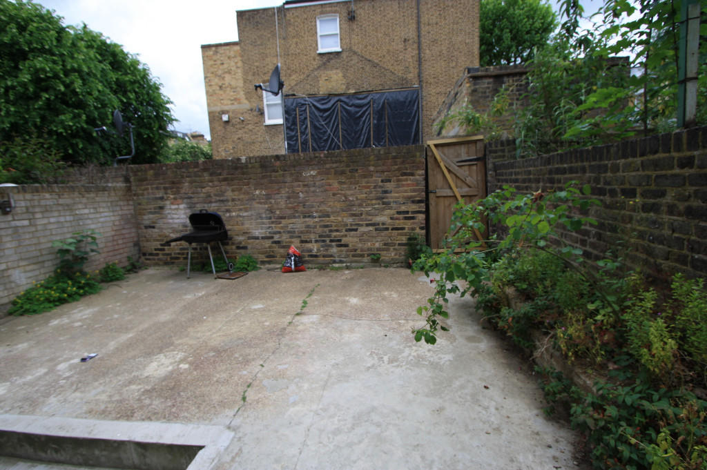
Photo 1 Photo 2 Photo 3 Photo 4
/ 4
Property details
Floor area
104 m²
Year built
England and Wales: 1900-1929
Deprivation
Decile 2 (5,063 of 33,755)
Street crime
1450 incidents within 1 mile (Apr 2026)
Additional details
- Garden
- Yes
Description
Listed by
Streatham
SW16 Limited
Reference: 50240329
EPC Rating & Upgrade Cost
Fetching EPC data… Refresh this page in a moment.
Flood risk
Zone: 1
Risk: Low
Job (default Low)
Rental Range
Estimated market rent for Hammersmith and Fulham. Low = conservative, Realistic = average, Optimistic = best case.
Based on Local Authority from postcode lookup → Hammersmith and Fulham.
LHA (30th percentile) floor for Inner West London: £1,346/mo (Apr 2025 – Mar 2026)
Location
Nearby
Nearest stations, universities and amenities (distance from property).
| Type | Name | Distance |
|---|---|---|
| Shop | Fairway Foods | 0.0 miles |
| Shop | Royal Laundrette | 0.0 miles |
| Bus stop | Goldhawk Road | 0.0 miles |
| Train station | Goldhawk Road | 0.2 miles |
| Train station | Shepherd's Bush | 0.3 miles |
| University | Scale Space White City | 0.9 miles |
| University | Kennet West Skills Centre | 1.9 miles |
| Hospital | Bridge Lane Health Centre | 3.1 miles |
| Hospital | The Portland Hospital | 3.7 miles |
Street-level crime
| Category | Count |
|---|---|
| Anti-social behaviour | 336 |
| Violence and sexual offences | 308 |
| Shoplifting | 264 |
| Public order | 112 |
| Other theft | 108 |
| Vehicle crime | 94 |
| Drugs | 55 |
| Theft from the person | 38 |
| Burglary | 36 |
| Criminal damage and arson | 36 |
| Robbery | 20 |
| Bicycle theft | 18 |
| Other crime | 16 |
| Possession of weapons | 9 |
| Total incidents | 1450 |
Within 1 mile during Apr 2026. Source: data.police.uk (England & Wales).
Schools nearby
Nearest open schools with Ofsted ratings (England). Closed schools are not shown. Data from Get Information about Schools and Ofsted.
| Name | Type | Distance | Ofsted |
|---|---|---|---|
| Addison Primary School | Primary | 0.2 miles | Good — 4 Nov 2011 |
| Flora Gardens Primary School | Primary | 0.2 miles | Good — 1 Aug 2022 |
| London Vocational Ballet School | Other | 0.3 miles | Good — 26 Sep 2023 |
| Miles Coverdale Primary School | Primary | 0.3 miles | Outstanding — 3 Jun 2024 |
| St Stephen's CofE Primary School | Primary | 0.3 miles | Outstanding — 11 Dec 2023 |
Rental Comparables
Residential lets from OpenRent and Rightmove for the area (same bedroom count). Use to validate rent estimates. Student lets are excluded.
| Title | Rent | Beds | Distance | As seen on |
|---|---|---|---|---|
| 1 Bed Flat, Sulgrave Road, W6 | £1,900/mo | 1 | 0.07 miles | OpenRent |
| 1 Bed Flat, Poplar Grove, W6 | £2,100/mo | 1 | 0.08 miles | OpenRent |
| Studio Flat, Batoum Gardens, W6 | £1,350/mo | 1 | 0.21 miles | OpenRent |
| Studio Flat, Lime Grove, W12 | £1,250/mo | 1 | 0.22 miles | OpenRent |
Average rent: £1,650/mo (4 listings)