26
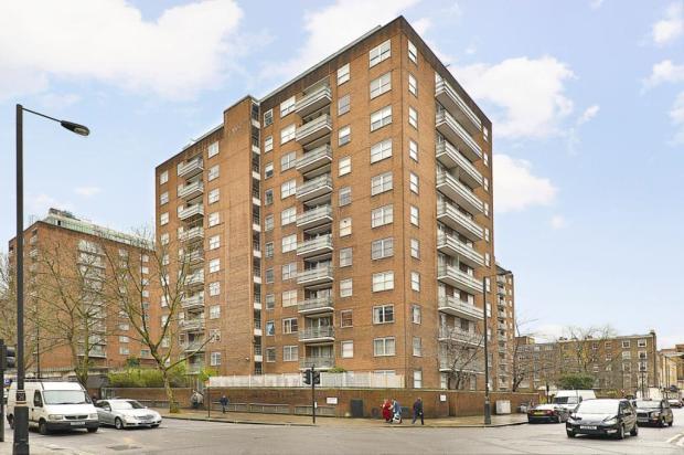
PORTMAN TOWERS, GEORGE STREET, LONDON, LONDON, GREATER LONDON W1H 7HN
£7,500,000


Property details
Tenure
LEASEHOLD
Last sold
£1,125,000 Sep 2004
Local average
£1,848,077 (+305.8%)
Deprivation
Decile 7 (20,579 of 33,755)
Street crime
2760 incidents within 1 mile (Mar 2026)
Additional details
- Parking
- Yes
Description
Listed by
London - Sales
Manors
Reference: 42397468
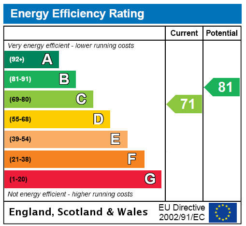
EPC Rating & Upgrade Cost
Fetching EPC data… Refresh this page in a moment.
Flood risk
Zone: 1
Risk: Low
Job (default Low)
Floorplans
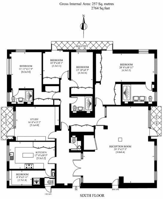
Floorplan
FENSA Certificates
This property has 1 FENSA certificate(s) on record, indicating window/door installations by FENSA-approved installers.
FENSA Certificate #13406464
Property Details
Street: 26 Portman Towers
Town: George Street
Postcode: W1H 7HN
Installation Details
Items: 21 windows and 5 doors
Certificate Issued: 26/02/2019
Work Completed: 21/01/2019
This certificate data was retrieved from FENSA's database
What is FENSA? FENSA (Fenestration Self-Assessment Scheme) is a government-authorised scheme that monitors building regulation compliance for replacement windows and doors. Certificates indicate that work was completed by FENSA-approved installers.
Price history
| Event | Date | Price | % change |
|---|---|---|---|
| Sold | 23/09/2004 (21 years ago) | £1,125,000 | — |
Source: HM Land Registry Price Paid Data. Crown copyright.
Sold Comparables
Same street and nearby sales within 0.25 miles (last 5 years). Data from Land Registry Price Paid.
| Address | Price | Date | Type |
|---|---|---|---|
| PORTMAN TOWERS 45 GEORGE STREET, LONDON, CITY OF WESTMINSTER, GREATER LONDON, W1H 7HN | £2,800,000 | 25/10/2023 | Flat |
| PORTMAN TOWERS 10 GEORGE STREET, LONDON, CITY OF WESTMINSTER, GREATER LONDON, W1H 7HN | £2,350,000 | 31/03/2023 | Flat |
| PORTMAN TOWERS 18 GEORGE STREET, LONDON, CITY OF WESTMINSTER, GREATER LONDON, W1H 7HN | £3,250,000 | 03/02/2023 | Flat |
| PORTMAN TOWERS 43 GEORGE STREET, LONDON, CITY OF WESTMINSTER, GREATER LONDON, W1H 7HN | £5,400,000 | 25/01/2023 | Flat |
| PORTMAN TOWERS 65 GEORGE STREET, LONDON, CITY OF WESTMINSTER, GREATER LONDON, W1H 7HW | £2,530,000 | 07/09/2022 | Flat |
| PORTMAN TOWERS 51 GEORGE STREET, LONDON, CITY OF WESTMINSTER, GREATER LONDON, W1H 7HW | £2,250,000 | 02/09/2022 | Flat |
| PORTMAN TOWERS 52 GEORGE STREET, LONDON, CITY OF WESTMINSTER, GREATER LONDON, W1H 7HW | £1,900,000 | 26/04/2022 | Flat |
| PORTMAN TOWERS 47 GEORGE STREET, LONDON, CITY OF WESTMINSTER, GREATER LONDON, W1H 7HW | £1,600,000 | 15/02/2022 | Flat |
| PORTMAN TOWERS 59 GEORGE STREET, LONDON, CITY OF WESTMINSTER, GREATER LONDON, W1H 7HW | £2,500,000 | 12/11/2021 | Flat |
Area average: £2,731,111 (9 sales)
Capital growth trend
Land Registry outcode average: last 12 months vs 5y and 10y ago (from sold prices).
House Price Index (HM Land Registry — official index, not sold-price averages): City of Westminster. Series: Flats and maisonettes. As of March 2026.
Rental Range
Estimated market rent for Westminster. Low = conservative, Realistic = average, Optimistic = best case.
Based on Local Authority from postcode lookup → Westminster.
LHA (30th percentile) floor for Central London: £3,052/mo (Apr 2025 – Mar 2026)
Location
Address
Montagu Street
Nearby
Nearest stations, universities and amenities (distance from property).
| Type | Name | Distance |
|---|---|---|
| Bus stop | George Street | 0.0 miles |
| Shop | Back in Action | 0.1 miles |
| Shop | Nigel Rayment | 0.1 miles |
| Bus stop | Portman Square | 0.1 miles |
| Train station | Marble Arch | 0.2 miles |
| Train station | Baker Street | 0.4 miles |
| University | LBS Behaviour Lab | 0.6 miles |
| Hospital | The Portland Hospital | 0.7 miles |
| Hospital | National Hospital for Neurology and Neurosurgery at Cleveland Street | 0.9 miles |
| University | Department of Geography | 1.1 miles |
Street-level crime
| Category | Count |
|---|---|
| Theft from the person | 615 |
| Other theft | 498 |
| Shoplifting | 382 |
| Violence and sexual offences | 358 |
| Anti-social behaviour | 357 |
| Burglary | 100 |
| Public order | 96 |
| Vehicle crime | 83 |
| Robbery | 78 |
| Criminal damage and arson | 76 |
| Drugs | 66 |
| Bicycle theft | 25 |
| Other crime | 19 |
| Possession of weapons | 7 |
| Total incidents | 2760 |
Within 1 mile during Mar 2026. Source: data.police.uk (England & Wales).
Schools nearby
Nearest open schools with Ofsted ratings (England). Closed schools are not shown. Data from Get Information about Schools and Ofsted.
| Name | Type | Distance | Ofsted |
|---|---|---|---|
| Wetherby Preparatory School | Other | 0.1 miles | — (No rating) |
| Halcyon London International School | Other | 0.2 miles | Outstanding — 27 May 2020 |
| Sylvia Young Theatre School | Other | 0.2 miles | — (No rating) |
| ICS London | Other | 0.3 miles | — (No rating) |
| St Vincent's Catholic Primary School | Primary | 0.3 miles | Outstanding — 4 Feb 2024 |
Rental Comparables
Rental listings exist nearby, but none matched the 5-bedroom count for this property.
Rent-driven metrics
Based on Area rent estimate.
- Rent ratio — Monthly rent ÷ purchase price (1% rule). 1%+ = strong, 0.8–1% = okay, <0.8% = weak for cashflow.
- Max investor price — Rent ÷ 0.8%; the price at which rent would be 0.8% of price (Stoke-style target).
- Target investor price — Rent ÷ 1%; the price at which rent would be 1% of price (strong cashflow band).
- Gross yield — Annual rent as % of purchase price (no costs).