The Gables
18, HIGH STREET, HUNTINGDON, SPALDWICK, CAMBRIDGESHIRE PE28 0TD
Listing type
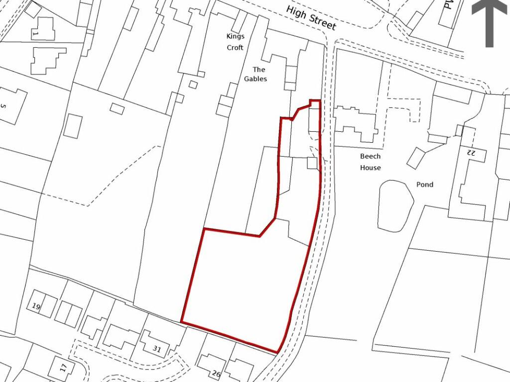
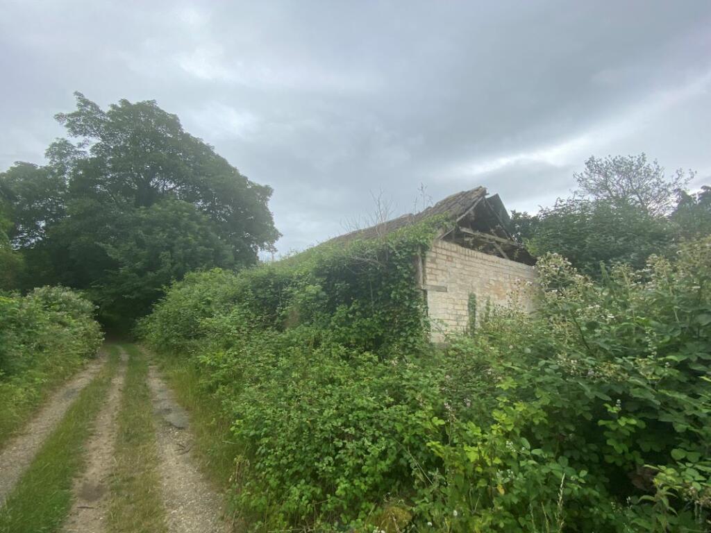
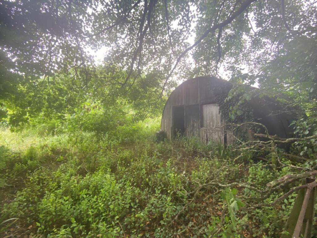
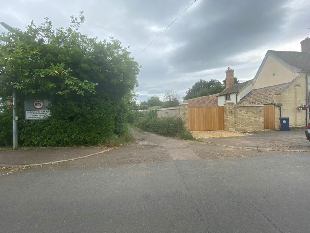
Photo 1 Photo 2 Photo 3 Photo 4
/ 4
Property details
Listing category
Auction
Tenure
FREEHOLD
Last sold
£575,000 Dec 2013
Local average
£3,267,961 (-96.6%)
Deprivation
Decile 7 (22,093 of 33,755)
Street crime
7 incidents within 1 mile (Apr 2026)
Key features
- Land in a residential area
- Approximately 0.80 Acre (0.33 Hectare)
- Development potential (subject to obtaining any necessary consents)
Description
As an auction property the details are subject to change. Please check our website for any updates or addendum entries.
Description
The property comprises a parcel of land approximately 0.80 Acre (0.33 Hectare)that is situated in a residential area. It is currently overgrown and un-managed and there are a number of dilapidated buildings on site. Please note the land is sold subject to an Overage Agreement and a copy with full details is contained within the Legal Pack.
Subject to obtaining any necessary consents the land may have development potential but interested parties should satisfy themselves in this regard and make their won enquiries direct with the Local Planning Office:
Location
Location
The land is situated to the south of18 High Street and to the north of Burton Way. A track leads from High Street along the eastern boundary of the land. Spaldwick is a village that lies just off the A14, approximately 7 miles to the east of Huntingdon.
Tenure
Freehold.
Buyer's Administration Fee
There will be a Buyer's Administration Fee of £2,400(inc VAT) payable upon exchange of contracts.
Additional Information
1. The information contained within the Particulars are given in good faith, but all descriptions, statements, dimensions ( these may have come from a third party source e.g. the seller, valuation reports or historic sales particulars), references to condition and permissions for the use and occupation or other details are made without responsibility and should not be relied upon as representation of fact.
2. If a video walk through, or any other form of virtual tour, is provided whilst every effort is made to accurately give an overview of the property we cannot give any warranty concerning the nature, and condition of the property and the suitability thereof for any and all activities and use. The video, or tour, is provided to assist only and without responsibility and should not be relied upon as representation of fact, or replace all appropriate due diligence a prudent purchaser would make.
Listed by
Manchester
Landwood Group
Reference: 137241173
EPC ratings on this postcode
We don't have a matched EPC for this property yet. Below are efficiency scores and details for other addresses on this postcode.
| Address | Current | Potential | Floor area | Age band | Type |
|---|---|---|---|---|---|
| 12, High Street, Spaldwick, HUNTINGDON | 69 | 78 | 68 m² | England and Wales: before 1900 | Flat |
| 12a High Street, Spaldwick, HUNTINGDON | 42 | 83 | 84 m² | England and Wales: before 1900 | Detached |
| 12b High Street, Spaldwick, HUNTINGDON | 39 | 64 | 64 m² | England and Wales: before 1900 | Flat |
| 12c High Street, Spaldwick, HUNTINGDON | 50 | 52 | 70 m² | England and Wales: before 1900 | Flat |
| 15 High Street, Spaldwick, HUNTINGDON | 21 | 21 | 303 m² | England and Wales: before 1900 | Detached |
| 16, High Street, Spaldwick, HUNTINGDON | 61 | 81 | 205 m² | England and Wales: before 1900 | Detached |
| 18, High Street, Spaldwick, HUNTINGDON | 18 | 61 | 272 m² | England and Wales: before 1900 | Detached |
| 40 High Street, Spaldwick, HUNTINGDON | 91 | 98 | 143 m² | — | Detached |
| 42 High Street, Spaldwick, HUNTINGDON | 91 | 98 | 143 m² | — | Detached |
| 43 High Street, Spaldwick, HUNTINGDON | 40 | 69 | 242 m² | England and Wales: 1900-1929 | Detached |
| 43, High Street, Spaldwick, HUNTINGDON | 37 | 71 | 239 m² | England and Wales: 1900-1929 | Detached |
| 45, High Street, Spaldwick, HUNTINGDON | 52 | 76 | 176 m² | England and Wales: 1996-2002 | Detached |
| 47 High Street, Spaldwick, HUNTINGDON | 69 | 70 | 153 m² | England and Wales: 1996-2002 | Detached |
| 47, High Street, Spaldwick, HUNTINGDON | 42 | 59 | 150 m² | England and Wales: 1996-2002 | Detached |
| 49, High Street, Spaldwick, HUNTINGDON | 48 | 60 | 149 m² | England and Wales: 1996-2002 | Detached |
Flood risk
Zone: 1
Risk: Low
Job (default Low)
Price history
| Event | Date | Price | % change |
|---|---|---|---|
| Sold | 10/12/2013 (12 years ago) | £575,000 | — |
Source: HM Land Registry Price Paid Data. Crown copyright.
Sold Comparables
Same street and nearby sales within 0.25 miles (last 5 years). Data from Land Registry Price Paid.
| Address | Price | Date | Type |
|---|---|---|---|
| 15 HIGH STREET, SPALDWICK, HUNTINGDON, HUNTINGDONSHIRE, CAMBRIDGESHIRE, PE28 0TD | £1,000,000 | 29/10/2021 | Other |
Area average: £1,000,000 (1 sale)
Capital growth trend
Land Registry outcode average: last 12 months vs 5y and 10y ago (from sold prices).
House Price Index (HM Land Registry — official index, not sold-price averages): Huntingdonshire. Series: All dwelling types. As of March 2026.
Rental Range
Estimated market rent for Huntingdonshire. Low = conservative, Realistic = average, Optimistic = best case.
Based on Local Authority from postcode lookup → Huntingdonshire.
LHA (30th percentile) floor for Huntingdon: Apr 2025 – Mar 2026
Location
Address
High Street
Nearby
Nearest stations, universities and amenities (distance from property).
| Type | Name | Distance |
|---|---|---|
| Shop | Number Twelve Village Shop & Deli | 0.0 miles |
| Bus stop | Long Lane | 0.0 miles |
| Shop | Catworth Stores | 2.7 miles |
| Train station | Huntingdon | 6.4 miles |
| Hospital | Linnea Cromwell Hospital | 6.6 miles |
| Hospital | MS (Multiple Scelerosis) Therapy Centre | 7.4 miles |
| Train station | St Neots | 8.6 miles |
Street-level crime
| Category | Count |
|---|---|
| Violence and sexual offences | 5 |
| Other crime | 1 |
| Other theft | 1 |
| Total incidents | 7 |
Within 1 mile during Apr 2026. Source: data.police.uk (England & Wales).
Schools nearby
Nearest open schools with Ofsted ratings (England). Closed schools are not shown. Data from Get Information about Schools and Ofsted.
| Name | Type | Distance | Ofsted |
|---|---|---|---|
| Spaldwick Primary School | Primary | 0.2 miles | Good — 5 Jun 2013 |
| Kimbolton Primary Academy | Primary | 3.4 miles | Good — 11 Jan 2017 |
| Brington CofE Primary School | Primary | 3.4 miles | Good — 16 Oct 2017 |
| Kimbolton School | Other | 3.7 miles | — (No rating) |
Rental Comparables
Residential lets from OpenRent and Rightmove for the area. Bedroom counts vary — use the Beds column to compare like-for-like lets. Student lets are excluded.
| Title | Rent | Beds | Distance | As seen on |
|---|---|---|---|---|
| 4 Bed Detached House, Fuller Close, PE28 | £2,500/mo | 4 | 0.16 miles | OpenRent |
Average rent: £2,500/mo (1 listing)
Rent-driven metrics
Based on OpenRent comparables.
- Rent ratio — Monthly rent ÷ purchase price (1% rule). 1%+ = strong, 0.8–1% = okay, <0.8% = weak for cashflow.
- Max investor price — Rent ÷ 0.8%; the price at which rent would be 0.8% of price (Stoke-style target).
- Target investor price — Rent ÷ 1%; the price at which rent would be 1% of price (strong cashflow band).
- Gross yield — Annual rent as % of purchase price (no costs).
- Cost-to-rent — Price ÷ annual rent (from OpenRent comparables). Under 14× = strong, 14–16× = acceptable, 17×+ = compressed.
- Cashflow — Rent minus mortgage, 10% maintenance, £25/mo compliance. Assumes 75% LTV, 3.95% APR (5yr fixed), 25yr term.
- ROI — Annual profit ÷ cash in (deposit + 4% purchase costs).
Enter House Number
Enter the house number to help us retrieve more accurate pricing history and property data.
Please log in to submit or correct the house number for this listing.
Log in to continue