Greywethers
HIGH STREET, FARINGDON, UFFINGTON, OXFORDSHIRE SN7 7RP
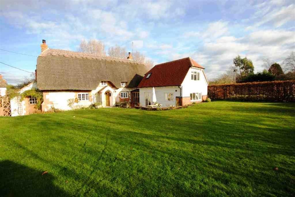


Photo 1 Photo 2 Photo 3 Photo 4 Photo 5 Photo 6 Photo 7 Photo 8 Photo 9 Photo 10 Photo 11 Photo 12
/ 12
Property details
Last sold
£650,000 Jun 2013
Local average
£678,854 (-4.3%)
Deprivation
Decile 7 (20,703 of 33,755)
Street crime
3 incidents within 1 mile (Apr 2026)
Additional details
- Parking
- Yes
Description
Bedroom 114' x 13'8
Bedroom 215'4 x 12'9 + En suite
Bedroom 39'9 x 8'6
Bedroom 413'7 x 8'3
Reception 113'4 x 13'3Family room
Reception 217'3 x 13'7 Sitting room
Reception 313'4 x 7'2 Playroom
Reception 410'1 x 7'5 Study/Bedroom 5
Reception 58'11 x 6'5 Utility/Boot room
Kitchen26'10 x 12'9 Kitchen/Dining
Listed by
Wantage
Douglas and Simmons Estate Agents
Reference: 40197215
EPC ratings on this postcode
We don't have a matched EPC for this property yet. Below are efficiency scores and details for other addresses on this postcode.
| Address | Current | Potential | Floor area | Age band | Type |
|---|---|---|---|---|---|
| 2 New Cottages, High Street, Uffington, FARINGDON | 58 | 82 | 79 m² | England and Wales: 1967-1975 | Detached |
| Apple Tree Cottage, High Street, Uffington, FARINGDON | 40 | 73 | 96 m² | England and Wales: 1950-1966 | Detached |
| Apple Tree Cottage, High Street, Uffington, FARINGDON | 39 | 85 | 80 m² | England and Wales: 1950-1966 | Detached |
| Brook Cottage, High Street, Uffington, FARINGDON | 48 | 68 | 133 m² | England and Wales: before 1900 | Detached |
| Curtis Cottage, High Street, Uffington, FARINGDON | 65 | 97 | 113 m² | England and Wales: before 1900 | Detached |
| Janecroft, High Street, Uffington, FARINGDON | 46 | 76 | 131 m² | England and Wales: 1967-1975 | Detached |
| Long Thatch, High Street, Uffington, FARINGDON | 54 | 63 | 215 m² | England and Wales: before 1900 | Detached |
| Packers Forge, High Street, Uffington, FARINGDON | 37 | 72 | 169 m² | England and Wales: before 1900 | Detached |
| Pear Tree Cottage, High Street, Uffington, FARINGDON | 48 | 69 | 215 m² | England and Wales: before 1900 | Detached |
| Pear Tree Cottage, High Street, Uffington, FARINGDON | 46 | 73 | 229 m² | England and Wales: before 1900 | Detached |
| The Anchorage, High Street, Uffington, FARINGDON | 86 | 94 | 152 m² | — | Detached |
| The Coach House, High Street, Uffington, FARINGDON | 57 | 67 | 187 m² | England and Wales: 1983-1990 | Detached |
| The Coach House, High Street, Uffington, FARINGDON | 38 | 73 | 155 m² | England and Wales: 1967-1975 | Detached |
| The Sombornes, High Street, Uffington, FARINGDON | 53 | 71 | 184 m² | England and Wales: 1991-1995 | Detached |
| Top Corner, High Street, Uffington, FARINGDON | 34 | 41 | 159 m² | England and Wales: 1967-1975 | Detached |
Flood risk
Zone: 1
Risk: Low
Job (default Low)
Floorplans

Floorplan 1
EPC Graphs

EPC 1
Price history
128% since 2002
| Event | Date | Price | % change |
|---|---|---|---|
| Sold | 07/06/2013 (13 years ago) | £650,000 | +68.8% |
| Sold | 25/06/2010 (15 years ago) | £385,000 | +35.1% |
| Sold | 11/01/2002 (24 years ago) | £285,000 | — |
Source: HM Land Registry Price Paid Data. Crown copyright.
Sold Comparables
Same street and nearby sales within 0.25 miles (last 5 years). Data from Land Registry Price Paid.
| Address | Price | Date | Type |
|---|---|---|---|
| Same street PEAR TREE COTTAGE HIGH STREET, UFFINGTON, FARINGDON, VALE OF WHITE HORSE, OXFORDSHIRE, SN7 7RP | £1,100,000 | 15/11/2023 | Detached |
| 10 WAYLANDS, UFFINGTON, FARINGDON, VALE OF WHITE HORSE, OXFORDSHIRE, SN7 7RR | £705,077 | 27/03/2023 | Detached |
| 15 CRAVEN COMMON, UFFINGTON, FARINGDON, VALE OF WHITE HORSE, OXFORDSHIRE, SN7 7RN | £575,000 | 30/11/2022 | Detached |
| MEADOWGOLD COTTAGE, 1 UPPER COMMON, UFFINGTON, FARINGDON, VALE OF WHITE HORSE, OXFORDSHIRE, SN7 7RU | £800,000 | 14/10/2022 | Detached |
| CRESLU HOUSE, UFFINGTON, FARINGDON, VALE OF WHITE HORSE, OXFORDSHIRE, SN7 7RQ | £1,330,000 | 11/07/2022 | Detached |
| WINGLETANG CHAPEL LANE, UFFINGTON, FARINGDON, VALE OF WHITE HORSE, OXFORDSHIRE, SN7 7RY | £460,000 | 24/03/2022 | Detached |
| BROOK COTTAGE, UFFINGTON, FARINGDON, VALE OF WHITE HORSE, OXFORDSHIRE, SN7 7RE | £632,500 | 27/01/2022 | Detached |
| THE MANOR, UFFINGTON, FARINGDON, VALE OF WHITE HORSE, OXFORDSHIRE, SN7 7RE | £1,500,000 | 15/12/2021 | Detached |
| CLOVELLY UPPER COMMON, UFFINGTON, FARINGDON, VALE OF WHITE HORSE, OXFORDSHIRE, SN7 7RU | £536,250 | 19/10/2021 | Detached |
| DRAGON HILL, UFFINGTON, FARINGDON, VALE OF WHITE HORSE, OXFORDSHIRE, SN7 7RE | £620,000 | 30/06/2021 | Detached |
| WHITE HORSE BROAD STREET, UFFINGTON, FARINGDON, VALE OF WHITE HORSE, OXFORDSHIRE, SN7 7RA | £875,000 | 18/06/2021 | Detached |
Street average: £1,100,000 (1 sale)
Area average: £803,383 (10 sales)
Capital growth trend
Land Registry outcode average: last 12 months vs 5y and 10y ago (from sold prices).
House Price Index (HM Land Registry — official index, not sold-price averages): Vale of White Horse. Series: Detached. As of March 2026.
Rental Range
Estimated market rent for Vale of White Horse. Low = conservative, Realistic = average, Optimistic = best case.
Based on Local Authority from postcode lookup → Vale of White Horse.
LHA (30th percentile) floor for Coventry: £997/mo (Apr 2025 – Mar 2026)
Location
Address
Uffington, Vale of White Horse, Oxfordshire, England, SN7 7RP, United Kingdom
Nearby
Nearest stations, universities and amenities (distance from property).
| Type | Name | Distance |
|---|---|---|
| Bus stop | Shotover Corner | 0.1 miles |
| Shop | Absolutely Gorgeous | 3.4 miles |
| Shop | Watchfield Opticians | 3.4 miles |
| Hospital | Wantage Community Hospital | 6.2 miles |
| University | University of Oxford | 7.9 miles |
| Train station | Richard Jefferies Halt | 8.7 miles |
| Train station | Lakeside | 8.8 miles |
| University | Royal Agricultural University (Cultural Heritage Institute) | 10.2 miles |
| Hospital | Marlborough House | 10.7 miles |
Street-level crime
| Category | Count |
|---|---|
| Violence and sexual offences | 2 |
| Criminal damage and arson | 1 |
| Total incidents | 3 |
Within 1 mile during Apr 2026. Source: data.police.uk (England & Wales).
Schools nearby
Nearest open schools with Ofsted ratings (England). Closed schools are not shown. Data from Get Information about Schools and Ofsted.
| Name | Type | Distance | Ofsted |
|---|---|---|---|
| Uffington Church of England Primary School | Primary | 0.2 miles | Good — 27 Sep 2022 |
| Longcot and Fernham Church of England Primary School | Primary | 2.3 miles | Requires improvement — 15 Jan 2023 |
| Shellingford Church of England (Voluntary Aided) School | Primary | 2.9 miles | Good — 24 May 2012 |
| Folly View Primary | Primary | 3.4 miles | Good — 15 Mar 2013 |
| Stanford In the Vale CofE Primary School | Primary | 3.5 miles | Good — 13 Mar 2013 |
Rental Comparables
Loading rental comparables for this postcode. Refresh in a few minutes.
Rent-driven metrics
Based on Area rent estimate.
- Rent ratio — Monthly rent ÷ purchase price (1% rule). 1%+ = strong, 0.8–1% = okay, <0.8% = weak for cashflow.
- Max investor price — Rent ÷ 0.8%; the price at which rent would be 0.8% of price (Stoke-style target).
- Target investor price — Rent ÷ 1%; the price at which rent would be 1% of price (strong cashflow band).
- Gross yield — Annual rent as % of purchase price (no costs).
Enter House Number
Enter the house number to help us retrieve more accurate pricing history and property data.
Please log in to submit or correct the house number for this listing.
Log in to continue