39 DARWIN DRIVE
TONBRIDGE, TONBRIDGE, KENT TN10 4SA
£275,000
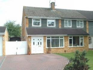
Photo 1
/ 1
Property details
Tenure
FREEHOLD
Floor area
116 m²
EPC rating
E
Year built
England and Wales: 1950-1966
Last sold
£272,000 Sep 2006
Price per m²
£2,371/m²
Deprivation
Decile 9 (27,374 of 33,755)
Street crime
55 incidents within 1 mile (Apr 2026)
Key features
- Semi detached house
- Lounge/dining room
- Kitchen/breakfast room
- Utility lobby
- Downstairs Cloakroom
- Three bedrooms
- Bathroom
- Gas central heating
Description
Dimensions
Bedroom 1:
Bedroom 2:
Bedroom 3:
Reception 1:
Kitchen:
14 4 x 8 3
9 6 x 8 3
10 maximum x 6
26 6 x 14 6
10 x 9 10
Listed by
Tonbridge
DB Estates
Reference: 12027779
EPC Rating & Upgrade Cost
Current rating: E
Potential rating: B
Inspection date: 08/04/2016
Expiry date: 07/04/2026 (expired)
Recommendations
- Increase loft insulation to 270 mm (350)
- Flat roof or sloping ceiling insulation (1,500)
- Cavity wall insulation (1,500)
- Floor insulation (solid floor) (6,000)
- Increase hot water cylinder insulation (30)
- Draughtproof single-glazed windows (120)
- Low energy lighting for all fixed outlets (60)
- Upgrade heating controls (450)
- Replace boiler with new condensing boiler (3,000)
- Solar water heating (6,000)
- Solar photovoltaic panels, 2.5 kWp (8,000)
Flood risk
Zone: 1
Risk: Low
Job (default Low)
Price history
207% since 1995
| Event | Date | Price | % change |
|---|---|---|---|
| Sold | 20/09/2006 (19 years ago) | £272,000 | +207.3% |
| Sold | 31/03/1995 (31 years ago) | £88,500 | — |
Source: HM Land Registry Price Paid Data. Crown copyright.
Sold Comparables
Same street and nearby sales within 0.25 miles (last 5 years). Data from Land Registry Price Paid.
| Address | Price | Date | Type |
|---|---|---|---|
| Same street 33 DARWIN DRIVE, TONBRIDGE, TONBRIDGE AND MALLING, KENT, TN10 4SA | £530,000 | 13/07/2023 | Semi-detached |
| Same street 17 DARWIN DRIVE, TONBRIDGE, TONBRIDGE AND MALLING, KENT, TN10 4SA | £529,000 | 25/05/2023 | Detached |
| Same street 19 DARWIN DRIVE, TONBRIDGE, TONBRIDGE AND MALLING, KENT, TN10 4SA | £455,000 | 24/02/2022 | Semi-detached |
| Same street 31 DARWIN DRIVE, TONBRIDGE, TONBRIDGE AND MALLING, KENT, TN10 4SA | £415,000 | 14/07/2021 | Semi-detached |
Street average: £482,250 (4 sales)
Capital growth trend
House Price Index (HM Land Registry — official index, not sold-price averages): Tonbridge and Malling. Series: All dwelling types. As of March 2026.
Rental Range
Estimated market rent for Tonbridge and Malling. Low = conservative, Realistic = average, Optimistic = best case.
Based on Local Authority from postcode lookup → Tonbridge and Malling.
LHA (30th percentile) floor for High Weald: £1,319/mo (Apr 2025 – Mar 2026)
Location
Nearby
Nearest stations, universities and amenities (distance from property).
| Type | Name | Distance |
|---|---|---|
| Bus stop | Darwin Drive | 0.1 miles |
| Bus stop | Reynolds Close | 0.1 miles |
| Shop | Sainsbury's Local | 0.3 miles |
| Shop | Morrisons Daily | 0.3 miles |
| University | Tonbridge Adult Education Centre | 1.8 miles |
| Train station | Tonbridge | 1.9 miles |
| Hospital | Tonbridge Cottage Hospital | 2.6 miles |
| Train station | Hildenborough | 2.6 miles |
| Hospital | Cygnet Hospital Godden Green | 4.5 miles |
| University | University for the Creative Arts, Maidstone TV Studios | 9.8 miles |
Street-level crime
| Category | Count |
|---|---|
| Violence and sexual offences | 23 |
| Criminal damage and arson | 12 |
| Anti-social behaviour | 7 |
| Drugs | 2 |
| Possession of weapons | 2 |
| Shoplifting | 2 |
| Vehicle crime | 2 |
| Bicycle theft | 1 |
| Burglary | 1 |
| Other crime | 1 |
| Other theft | 1 |
| Public order | 1 |
| Total incidents | 55 |
Within 1 mile during Apr 2026. Source: data.police.uk (England & Wales).
Schools nearby
Nearest open schools with Ofsted ratings (England). Closed schools are not shown. Data from Get Information about Schools and Ofsted.
| Name | Type | Distance | Ofsted |
|---|---|---|---|
| Woodlands Primary School | Primary | 0.3 miles | Good — 27 Jun 2019 |
| Cage Green Primary School | Primary | 0.3 miles | Good — 14 Dec 2023 |
| Leigh Academy Hugh Christie | Secondary | 0.4 miles | Requires improvement — 27 Nov 2023 |
| Skills for Independence and Employability Ltd | Other | 0.4 miles | — (No rating) |
| Long Mead Community Primary School | Primary | 0.8 miles | Good — 17 Oct 2019 |
Rental Comparables
Rental listings exist nearby, but none matched the 3-bedroom count for this property.
Rent-driven metrics
Based on Area rent estimate.
- Rent ratio — Monthly rent ÷ purchase price (1% rule). 1%+ = strong, 0.8–1% = okay, <0.8% = weak for cashflow.
- Max investor price — Rent ÷ 0.8%; the price at which rent would be 0.8% of price (Stoke-style target).
- Target investor price — Rent ÷ 1%; the price at which rent would be 1% of price (strong cashflow band).
- Gross yield — Annual rent as % of purchase price (no costs).