66 CLAREMONT AVENUE
BOURNEMOUTH, BOURNEMOUTH BH9 3HB
£225,000
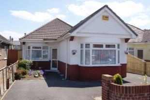
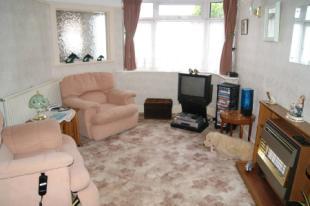
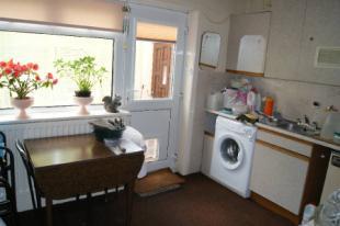
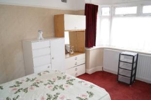
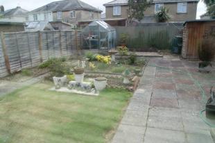
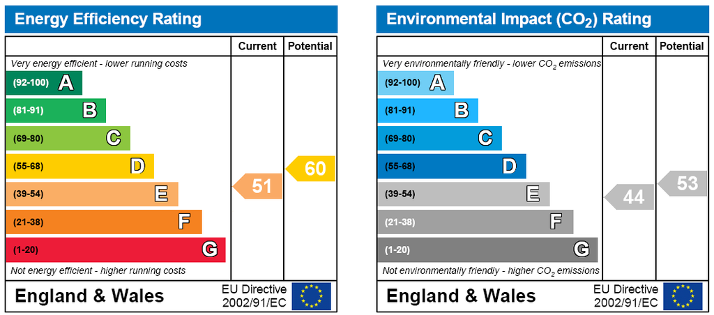
Photo 1 Photo 2 Photo 3 Photo 4 Photo 5 EPC
/ 6
Property details
Last sold
£213,000 Sep 2010
Local average
£407,294 (-44.8%)
Deprivation
Decile 5 (14,926 of 33,755)
Street crime
252 incidents within 1 mile (Apr 2026)
Additional details
- Parking
- Yes
- Garden
- Yes
Description
DESCRIPTION/SITUATION A two bedroom detached bungalow situated on a level plot in this popular residential road and offering scope to update to a purchasers own taste and requirements. The rear garden is easy to maintain as is the front garden which affords off road parking facilities. The bungalow is situated in a convenient location within walking distance of bus routes in Castle Lane West and the Castle Point Shopping Centre is only a short drive away. The bungalow is being sold with the added attraction of no onward chain.
ENTRANCE HALLWAY
THROUGH LOUNGE/DINER
LOUNGE AREA15'5" x 9'11" (4.7m x 3.02m).
DINING AREA8'10" x 8' (2.7m x 2.44m).
KITCHEN12'7" x 8'9" (3.84m x 2.67m).
CONSERVATORY18' x 5' (5.49m x 1.52m).
BEDROOM ONE13'5" into bay x 10'10" (4.1m into bay x 3.3m).
BEDROOM TWO11'5" x 7'6" (3.48m x 2.29m).
BATHROOM8'10" x 5'5" (2.7m x 1.65m).
OUTSIDE The front garden affords off road parking facilities. Rear garden laid for ease of maintenance.
Listed by
Charminster
Countrywide UK Sales - Connells
Reference: 30353684
EPC Rating & Upgrade Cost
Fetching EPC data… Refresh this page in a moment.
Flood risk
Zone: 1
Risk: Low
Job (default Low)
Floorplans
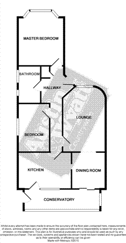
Floorplan 1
FENSA Certificates
This property has 1 FENSA certificate(s) on record, indicating window/door installations by FENSA-approved installers.
FENSA Certificate #8581251
Property Details
Street: 66 Claremont Avenue
Town: BOURNEMOUTH
Postcode: BH9 3HB
Installation Details
Items: 2 windows
Certificate Issued: 12/12/2011
Work Completed: 30/11/2011
This certificate data was retrieved from FENSA's database
What is FENSA? FENSA (Fenestration Self-Assessment Scheme) is a government-authorised scheme that monitors building regulation compliance for replacement windows and doors. Certificates indicate that work was completed by FENSA-approved installers.
Price history
| Event | Date | Price | % change |
|---|---|---|---|
| Sold | 23/09/2010 (15 years ago) | £213,000 | — |
Source: HM Land Registry Price Paid Data. Crown copyright.
Sold Comparables
Same street and nearby sales within 0.25 miles (last 5 years). Data from Land Registry Price Paid.
| Address | Price | Date | Type |
|---|---|---|---|
| 201 CASTLE LANE WEST, BOURNEMOUTH, BOURNEMOUTH, CHRISTCHURCH AND POOLE, BH9 3LD | £425,000 | 08/01/2026 | Detached |
| 16 HUNTVALE ROAD, MOORDOWN, BOURNEMOUTH, BOURNEMOUTH, CHRISTCHURCH AND POOLE, BH9 3HP | £380,000 | 10/12/2025 | Detached |
| 5 LITTLECROFT AVENUE, BOURNEMOUTH, BOURNEMOUTH, CHRISTCHURCH AND POOLE, BH9 3HR | £465,000 | 01/07/2025 | Detached |
| 203 CASTLE LANE WEST, BOURNEMOUTH, BOURNEMOUTH, CHRISTCHURCH AND POOLE, BH9 3LD | £399,950 | 06/12/2023 | Detached |
| 96 WEST WAY, BOURNEMOUTH, BOURNEMOUTH, CHRISTCHURCH AND POOLE, BH9 3DZ | £685,000 | 26/09/2023 | Detached |
| 1 LITTLECROFT AVENUE, BOURNEMOUTH, BOURNEMOUTH, CHRISTCHURCH AND POOLE, BH9 3HR | £355,000 | 08/09/2023 | Detached |
| 23 HUNTFIELD ROAD, BOURNEMOUTH, BOURNEMOUTH, CHRISTCHURCH AND POOLE, BH9 3HN | £414,000 | 14/08/2023 | Detached |
| 68 UPLANDS ROAD, BOURNEMOUTH, BOURNEMOUTH, CHRISTCHURCH AND POOLE, BH8 9SS | £620,000 | 11/08/2023 | Detached |
| 68 CLAREMONT AVENUE, BOURNEMOUTH, BOURNEMOUTH, CHRISTCHURCH AND POOLE, BH9 3HB | £315,000 | 13/01/2023 | Detached |
| 32 HUNTFIELD ROAD, BOURNEMOUTH, BOURNEMOUTH, CHRISTCHURCH AND POOLE, BH9 3HN | £337,500 | 16/12/2022 | Detached |
| 52 UPLANDS ROAD, BOURNEMOUTH, BOURNEMOUTH, CHRISTCHURCH AND POOLE, BH8 9SS | £465,000 | 16/12/2022 | Detached |
| 26 HUNTFIELD ROAD, BOURNEMOUTH, BOURNEMOUTH, CHRISTCHURCH AND POOLE, BH9 3HN | £480,000 | 09/12/2022 | Detached |
| 61 UPLANDS ROAD, BOURNEMOUTH, BOURNEMOUTH, CHRISTCHURCH AND POOLE, BH8 9SR | £775,000 | 01/12/2022 | Detached |
| 20 HUNTVALE ROAD, MOORDOWN, BOURNEMOUTH, BOURNEMOUTH, CHRISTCHURCH AND POOLE, BH9 3HP | £307,000 | 18/11/2022 | Detached |
| 12 TOWNSVILLE ROAD, BOURNEMOUTH, BOURNEMOUTH, CHRISTCHURCH AND POOLE, BH9 3HL | £215,000 | 17/10/2022 | Detached |
| 64 WEST WAY, BOURNEMOUTH, BOURNEMOUTH, CHRISTCHURCH AND POOLE, BH9 3EA | £545,000 | 14/10/2022 | Detached |
| 18 UPLANDS ROAD, BOURNEMOUTH, BOURNEMOUTH, CHRISTCHURCH AND POOLE, BH8 9SS | £582,500 | 16/09/2022 | Detached |
| 4 BROCKENHURST ROAD, BOURNEMOUTH, BOURNEMOUTH, CHRISTCHURCH AND POOLE, BH9 3ER | £390,000 | 13/09/2022 | Detached |
| 42 UPLANDS ROAD, BOURNEMOUTH, BOURNEMOUTH, CHRISTCHURCH AND POOLE, BH8 9SS | £530,000 | 26/08/2022 | Detached |
| 11 UPLANDS ROAD, BOURNEMOUTH, BOURNEMOUTH, CHRISTCHURCH AND POOLE, BH8 9SR | £805,000 | 21/07/2022 | Detached |
Area average: £474,548 (20 sales)
Capital growth trend
Land Registry outcode average: last 12 months vs 5y and 10y ago (from sold prices).
House Price Index (HM Land Registry — official index, not sold-price averages): Bournemouth Christchurch and Poole. Series: Detached. As of March 2026.
Rental Range
Estimated market rent for Bournemouth, Christchurch and Poole. Low = conservative, Realistic = average, Optimistic = best case.
Based on Local Authority from postcode lookup → Bournemouth, Christchurch and Poole.
Location
Nearby
Nearest stations, universities and amenities (distance from property).
| Type | Name | Distance |
|---|---|---|
| Bus stop | Claremont Avenue | 0.1 miles |
| Bus stop | Broadway Co-op | 0.1 miles |
| Shop | The Co-operative Food | 0.2 miles |
| Shop | Pets Corner | 0.2 miles |
| Hospital | Nuffield Health Bournemouth Hospital | 1.7 miles |
| University | Bournemouth University (Talbot Campus) | 1.7 miles |
| University | Bournemouth University | 1.7 miles |
| Hospital | Royal Bournemouth Hospital | 1.7 miles |
| Train station | Bournemouth | 1.8 miles |
| Train station | Pokesdown | 2.2 miles |
Street-level crime
| Category | Count |
|---|---|
| Shoplifting | 90 |
| Violence and sexual offences | 64 |
| Anti-social behaviour | 43 |
| Vehicle crime | 16 |
| Burglary | 8 |
| Other theft | 8 |
| Criminal damage and arson | 5 |
| Public order | 5 |
| Robbery | 4 |
| Bicycle theft | 3 |
| Drugs | 2 |
| Other crime | 2 |
| Possession of weapons | 2 |
| Total incidents | 252 |
Within 1 mile during Apr 2026. Source: data.police.uk (England & Wales).
Schools nearby
Nearest open schools with Ofsted ratings (England). Closed schools are not shown. Data from Get Information about Schools and Ofsted.
| Name | Type | Distance | Ofsted |
|---|---|---|---|
| St. Walburga's Catholic Primary School | Primary | 0.3 miles | Good — 2 Feb 2020 |
| Bournemouth School | Secondary | 0.4 miles | Outstanding — 2 May 2024 |
| Bournemouth School for Girls | Secondary | 0.4 miles | Outstanding — 17 Jun 2024 |
| Queen's Park Infant Academy | Primary | 0.4 miles | Good — 24 Jul 2013 |
| Queen's Park Academy | Primary | 0.4 miles | Outstanding — 10 Jul 2014 |
Rental Comparables
Rental listings exist nearby, but none matched the 2-bedroom count for this property.
Rent-driven metrics
Based on Area rent estimate.
- Rent ratio — Monthly rent ÷ purchase price (1% rule). 1%+ = strong, 0.8–1% = okay, <0.8% = weak for cashflow.
- Max investor price — Rent ÷ 0.8%; the price at which rent would be 0.8% of price (Stoke-style target).
- Target investor price — Rent ÷ 1%; the price at which rent would be 1% of price (strong cashflow band).
- Gross yield — Annual rent as % of purchase price (no costs).