Land At The East Of Newport
Newport, Shropshire TF10 8BX
/ 2
Property details
Tenure
FREEHOLD
Local average
£219,000 (-100%)
Deprivation
Decile 6 (20,055 of 33,755)
Street crime
33 incidents within 1 mile (Apr 2026)
Key features
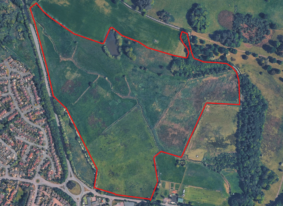
- Approximately 66.52 acres (26.92 hectares) of freehold agricultural land with strategic development potential
- Attractive semi-rural location close to Newport town centre and all local amenities
- Prominent location with roadside frontage along A41
- Excellent transport links via A41, A518 & M54 motorway
Description
The site benefits from multiple access points, including frontage onto the A518 and Walkley Bank, and lies adjacent to the A41, providing excellent connectivity to the wider road network.
The land is predominately level, albeit sloping to the north, and features attractive natural elements including an established woodland area to the north-east and a brook running through the site.
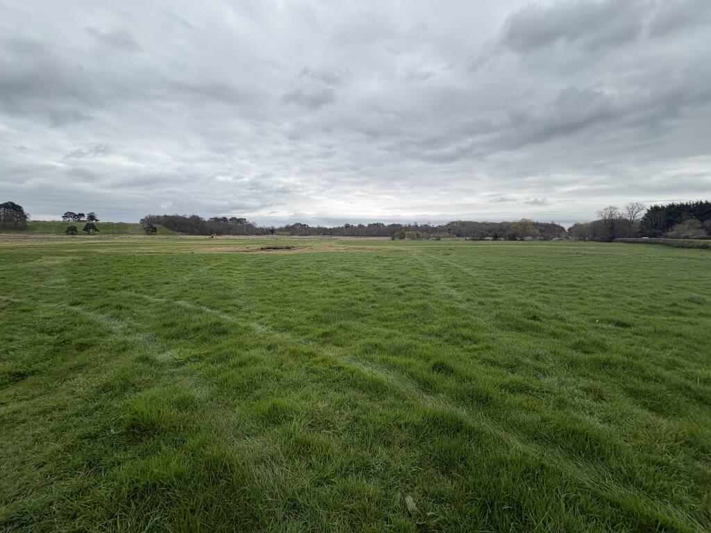
Currently used for agricultural grazing and with no existing built development, the site is suitable for a wide range of potential uses, subject to the necessary planning consents.
Listed by
Andrew Dixon & Company , Telford
Reference: 747323855038913
EPC ratings on this postcode
We don't have a matched EPC for this property yet. Below are efficiency scores and details for other addresses on this postcode.
| Address | Current | Potential | Floor area | Age band | Type |
|---|---|---|---|---|---|
| Brook House, Meretown, NEWPORT | 14 | 28 | 237 m² | England and Wales: before 1900 | Detached |
| Cadwell Barn, Meretown, NEWPORT | 71 | 79 | 163 m² | England and Wales: 1996-2002 | Detached |
| Dovecote Meretown Court, Meretown, NEWPORT | 67 | 85 | 110 m² | England and Wales: before 1900 | Detached |
| Dovecote, Meretown Court, Meretown, NEWPORT | 65 | 84 | 113 m² | England and Wales: 1991-1995 | Detached |
| Gorleston Cottage, Meretown, NEWPORT | 61 | 81 | 207 m² | — | Detached |
| Granary, Meretown Court, Meretown, NEWPORT | 56 | 89 | 131 m² | England and Wales: 1991-1995 | Detached |
| Loxdale, Meretown, NEWPORT | 60 | 90 | 132 m² | — | Detached |
| Meretown Cottage, Meretown, NEWPORT | 32 | 97 | 96 m² | England and Wales: before 1900 | Detached |
| Meretown House, Meretown Lane, NEWPORT | 29 | 71 | 686 m² | England and Wales: before 1900 | Detached |
| National Foaling Bank, Meretown House, Meretown, NEWPORT | 40 | 72 | 455 m² | England and Wales: before 1900 | Detached |
| Rear Apartment, Meretown Grange, Meretown, Newport | 49 | 70 | 85 m² | England and Wales: before 1900 | Flat |
| The Byre, Meretown, NEWPORT | 55 | 78 | 199 m² | England and Wales: 1996-2002 | Detached |
| The Hayloft, Meretown, NEWPORT | 64 | 68 | 155 m² | England and Wales: 1996-2002 | Detached |
| The Hayloft, Meretown, NEWPORT | 59 | 89 | 142 m² | England and Wales: 1991-1995 | Detached |
| Warwick Cottage, Meretown, NEWPORT | 1 | 74 | 208 m² | England and Wales: 1900-1929 | Detached |
Flood risk
Zone: 1
Risk: Low
Job (default Low)
Price history
No sales history found for this property in Land Registry Price Paid data.
Sold Comparables
Same street and nearby sales within 0.25 miles (last 5 years). Data from Land Registry Price Paid.
| Address | Price | Date | Type |
|---|---|---|---|
| MAIDENHEAD AQUATICS STAFFORD ROAD, NEWPORT, WREKIN, TF10 9BY | £5,455,000 | 03/11/2021 | Other |
| MERE PARK GARDEN CENTRE RETAIL AREA STAFFORD ROAD, NEWPORT, WREKIN, TF10 9BY | £5,455,000 | 03/11/2021 | Other |
| MERE PARK GARDEN CENTRE RETAIL AREA STAFFORD ROAD, NEWPORT, WREKIN, TF10 9BY | £5,455,000 | 03/11/2021 | Other |
| MERE PARK GARDEN CENTRE RETAIL AREA STAFFORD ROAD, NEWPORT, WREKIN, TF10 9BY | £5,455,000 | 03/11/2021 | Other |
| MERE PARK GARDEN CENTRE CHILDREN'S DAY NURSERY STAFFORD ROAD, NEWPORT, WREKIN, TF10 9BY | £757,500 | 02/11/2021 | Other |
Area average: £4,515,500 (5 sales)
Capital growth trend
Land Registry outcode average: last 12 months vs 5y and 10y ago (from sold prices).
House Price Index (HM Land Registry — official index, not sold-price averages): Stafford. Series: All dwelling types. As of March 2026.
Rental Range
Estimated market rent for Stafford. Low = conservative, Realistic = average, Optimistic = best case.
Based on Local Authority from postcode lookup → Stafford.
LHA (30th percentile) floor for Shropshire: Apr 2025 – Mar 2026
Location
Address
Stafford Road
Nearby
Nearest stations, universities and amenities (distance from property).
| Type | Name | Distance |
|---|---|---|
| Shop | Mere Park Garden Centre | 0.1 miles |
| Bus stop | Unknown | 0.2 miles |
| Bus stop | Daniels Cross | 0.2 miles |
| Shop | Newport News and Off Licence | 0.4 miles |
| University | Harper Adams University | 2.9 miles |
| Hospital | Shrewsbury & Telford Hospital NHS Trust Sterile Services Department (SSD) | 6.4 miles |
| Train station | Oakengates | 6.6 miles |
| University | University Of Wolverhampton (Shropshire Campus) (Business School) | 6.7 miles |
| Train station | Telford Central | 7.1 miles |
| Hospital | Bickerstaff Endoscopy Unit | 7.5 miles |
Street-level crime
| Category | Count |
|---|---|
| Violence and sexual offences | 20 |
| Criminal damage and arson | 3 |
| Other theft | 3 |
| Burglary | 2 |
| Public order | 2 |
| Robbery | 1 |
| Shoplifting | 1 |
| Vehicle crime | 1 |
| Total incidents | 33 |
Within 1 mile during Apr 2026. Source: data.police.uk (England & Wales).
Schools nearby
Nearest open schools with Ofsted ratings (England). Closed schools are not shown. Data from Get Information about Schools and Ofsted.
| Name | Type | Distance | Ofsted |
|---|---|---|---|
| The Burton Borough School | Secondary | 0.6 miles | Requires improvement — 13 Feb 2022 |
| Newport Infant School and Nursery | Primary | 0.7 miles | Good — 20 Dec 2023 |
| Newport Church of England Voluntary Controlled Junior School | Primary | 0.7 miles | Good — 18 Jan 2024 |
| Haberdashers' Castle House School | Other | 0.8 miles | — (No rating) |
| Haberdashers' Adams | Secondary | 0.9 miles | Good — 27 Jun 2022 |
Rental Comparables
Residential lets from OpenRent and Rightmove for the area. Bedroom counts vary — use the Beds column to compare like-for-like lets. Student lets are excluded.
| Title | Rent | Beds | Distance | As seen on |
|---|---|---|---|---|
| 4 Bed End Terrace, Meadow Road, TF10 | £1,580/mo | 4 | 0.5 miles | OpenRent |
Average rent: £1,580/mo (1 listing)
Rent-driven metrics
Based on OpenRent comparables.
- Rent ratio — Monthly rent ÷ purchase price (1% rule). 1%+ = strong, 0.8–1% = okay, <0.8% = weak for cashflow.
- Max investor price — Rent ÷ 0.8%; the price at which rent would be 0.8% of price (Stoke-style target).
- Target investor price — Rent ÷ 1%; the price at which rent would be 1% of price (strong cashflow band).
- Gross yield — Annual rent as % of purchase price (no costs).
- Cashflow — Rent minus mortgage, 10% maintenance, £25/mo compliance. Assumes 75% LTV, 3.95% APR (5yr fixed), 25yr term.
- ROI — Annual profit ÷ cash in (deposit + 4% purchase costs).
Enter House Number
Enter the house number to help us retrieve more accurate pricing history and property data.
Please log in to submit or correct the house number for this listing.
Log in to continue