153 STOURVALE ROAD
BOURNEMOUTH, BOURNEMOUTH, BOURNEMOUTH BH6 5HG
£450 pcm
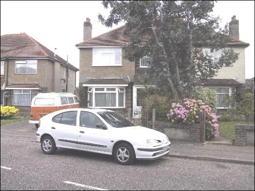
Photo 1
/ 1
Property details
Deprivation
Decile 6 (17,126 of 33,755)
Street crime
162 incidents within 1 mile (Mar 2026)
Key features
- First floor
- Unfurnished
- One bedroom
- Parking
Additional details
- Parking
- Yes
Description
Listed by
Southbourne
Bullock & Lees
Reference: 6865090
EPC Rating & Upgrade Cost
Fetching EPC data… Refresh this page in a moment.
Flood risk
Zone: 1
Risk: Low
Job (default Low)
FENSA Certificates
This property has 1 FENSA certificate(s) on record, indicating window/door installations by FENSA-approved installers.
FENSA Certificate #135247
Property Details
Street: 153 STOURVALE ROAD
Town: BOURNEMOUTH
Postcode: BH6 5HG
Installation Details
Items: 4 windows and 3 doors
Certificate Issued: 03/12/2002
Work Completed: 07/08/2002
This certificate data was retrieved from FENSA's database
What is FENSA? FENSA (Fenestration Self-Assessment Scheme) is a government-authorised scheme that monitors building regulation compliance for replacement windows and doors. Certificates indicate that work was completed by FENSA-approved installers.
Rental Range
Estimated market rent for Bournemouth, Christchurch and Poole. Low = conservative, Realistic = average, Optimistic = best case.
Based on Local Authority from postcode lookup → Bournemouth, Christchurch and Poole.
Location
Nearby
Nearest stations, universities and amenities (distance from property).
| Type | Name | Distance |
|---|---|---|
| Bus stop | Burleigh Road | 0.1 miles |
| Shop | 21st Century Hair Design | 0.2 miles |
| Shop | Gentlemens & Rogues | 0.2 miles |
| Train station | Pokesdown | 0.7 miles |
| Train station | Christchurch | 1.2 miles |
| University | Bournemouth University (Talbot Campus) | 3.7 miles |
| University | Arts University Bournemouth | 3.8 miles |
| Hospital | Alderney Hospital | 5.8 miles |
| Hospital | Poole General Hospital | 7.2 miles |
Street-level crime
| Category | Count |
|---|---|
| Violence and sexual offences | 50 |
| Anti-social behaviour | 44 |
| Public order | 13 |
| Shoplifting | 12 |
| Criminal damage and arson | 11 |
| Vehicle crime | 10 |
| Other theft | 8 |
| Bicycle theft | 5 |
| Burglary | 5 |
| Drugs | 3 |
| Other crime | 1 |
| Total incidents | 162 |
Within 1 mile during Mar 2026. Source: data.police.uk (England & Wales).
Schools nearby
Nearest open schools with Ofsted ratings (England). Closed schools are not shown. Data from Get Information about Schools and Ofsted.
| Name | Type | Distance | Ofsted |
|---|---|---|---|
| Stourfield Infant School | Primary | 0.1 miles | Good — 26 Mar 2024 |
| Stourfield Junior School | Primary | 0.1 miles | Good — 24 May 2013 |
| St James' Church of England Primary Academy | Primary | 0.5 miles | Good — 22 Apr 2013 |
| Pokesdown Community Primary School | Primary | 0.7 miles | Good — 17 Sep 2024 |
| Tregonwell Academy | Other | 0.7 miles | Outstanding — 13 May 2013 |
Rental Comparables
Residential lets from OpenRent and Rightmove for the area (same bedroom count). Use to validate rent estimates. Student lets are excluded.
| Title | Rent | Beds | Distance | As seen on |
|---|---|---|---|---|
| Studio Flat, Southbourne Road, BH6 | £850/mo | 1 | 0.47 miles | OpenRent |
| 1 Bed Flat, Seabourne Road, BH5 | £950/mo | 1 | 0.57 miles | OpenRent |
| 1 Bed Flat, Stourfield Road, BH5 | £796/mo | 1 | 0.58 miles | OpenRent |
| 1 Bed Flat, Calendula Place, BH7 | £810/mo | 1 | 0.97 miles | OpenRent |
| 1 Bed Flat, Summerfields, BH7 | £1,200/mo | 1 | 1.09 miles | OpenRent |
| 1 Bed Flat, Ashley Road, BH1 | £812/mo | 1 | 1.21 miles | OpenRent |
Average rent: £903/mo (6 listings)