17 MAES LLAN
BRIDGEND, KENFIG HILL, BRIDGEND CF33 6DX
£117,950
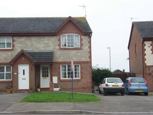
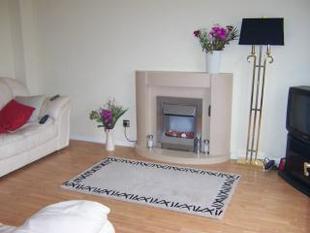
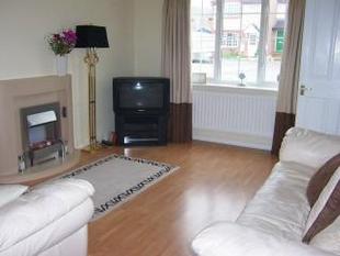
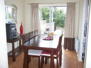
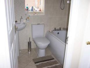
Photo 1 Photo 2 Photo 3 Photo 4 Photo 5
/ 5
Property details
Floor area
68 m²
Last sold
£115,000 Feb 2014
Local average
£509,750 (-76.9%)
Street crime
65 incidents within 1 mile (Mar 2026)
Key features
- Kenfig Hill
- House
- 3 Bedrooms
- Gas central heating
- 2 Reception Rooms
Description
Listed by
Bridgend
Payton, Jewell & Caines
Reference: 9722198
EPC Rating & Upgrade Cost
Fetching EPC data… Refresh this page in a moment.
Flood risk
Zone: 1
Risk: Low
Job (default Low)
Price history
117% since 1998
| Event | Date | Price | % change |
|---|---|---|---|
| Sold | 06/02/2014 (12 years ago) | £115,000 | 0% |
| Sold | 23/06/2006 (19 years ago) | £115,000 | +47.4% |
| Sold | 11/07/2003 (22 years ago) | £78,000 | +47.2% |
| Sold | 01/12/1998 (27 years ago) | £53,000 | — |
Source: HM Land Registry Price Paid Data. Crown copyright.
Sold Comparables
Same street and nearby sales within 0.25 miles (last 5 years). Data from Land Registry Price Paid.
| Address | Price | Date | Type |
|---|---|---|---|
| 59 COMMERCIAL STREET, KENFIG HILL, BRIDGEND, CF33 6DH | £119,500 | 21/08/2024 | Other |
| 48 HIGH STREET, KENFIG HILL, BRIDGEND, CF33 6DR | £110,000 | 08/06/2023 | Other |
Area average: £114,750 (2 sales)
Capital growth trend
House Price Index (HM Land Registry — official index, not sold-price averages): Bridgend. Series: All dwelling types. As of February 2026.
Rental Range
Estimated market rent for Bridgend. Low = conservative, Realistic = average, Optimistic = best case.
Based on Local Authority from postcode lookup → Bridgend.
Location
Nearby
Nearest stations, universities and amenities (distance from property).
| Type | Name | Distance |
|---|---|---|
| Shop | theFringe | 0.2 miles |
| Bus stop | Commercial Street (NE) | 0.3 miles |
| Shop | Spar | 0.3 miles |
| Bus stop | Unknown | 0.8 miles |
| Train station | Pyle | 1.0 miles |
| Hospital | Porthcawl Medical Centre | 3.1 miles |
| University | Union School of Theology | 3.4 miles |
| Train station | Tondu | 3.7 miles |
| University | Swansea University Bay Campus | 10.9 miles |
Street-level crime
| Category | Count |
|---|---|
| Violence and sexual offences | 29 |
| Public order | 12 |
| Anti-social behaviour | 9 |
| Criminal damage and arson | 5 |
| Burglary | 3 |
| Other theft | 3 |
| Vehicle crime | 3 |
| Drugs | 1 |
| Total incidents | 65 |
Within 1 mile during Mar 2026. Source: data.police.uk (England & Wales).
Schools nearby
Nearest open schools with Ofsted ratings (England). Closed schools are not shown. Data from Get Information about Schools and Ofsted.
| Name | Type | Distance | Ofsted |
|---|---|---|---|
| Cynffig Comprehensive School | Other | 0.2 miles | — (No rating) |
| Pil Primary School | Other | 0.7 miles | — (No rating) |
| Cefn Cribwr Primary School | Other | 1.2 miles | — (No rating) |
| Afon-Y-Felin Primary School | Other | 1.2 miles | — (No rating) |
| Ysgol Y Ferch O'r Sger | Other | 1.3 miles | — (No rating) |
Rental Comparables
Loading rental comparables for this postcode. Refresh in a few minutes.
Rent-driven metrics
Based on Area rent estimate.
- Rent ratio — Monthly rent ÷ purchase price (1% rule). 1%+ = strong, 0.8–1% = okay, <0.8% = weak for cashflow.
- Max investor price — Rent ÷ 0.8%; the price at which rent would be 0.8% of price (Stoke-style target).
- Target investor price — Rent ÷ 1%; the price at which rent would be 1% of price (strong cashflow band).
- Gross yield — Annual rent as % of purchase price (no costs).