Stafford Road
Stone, ST15, ST15 0ET
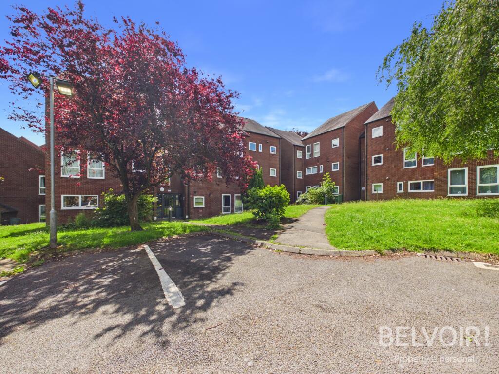
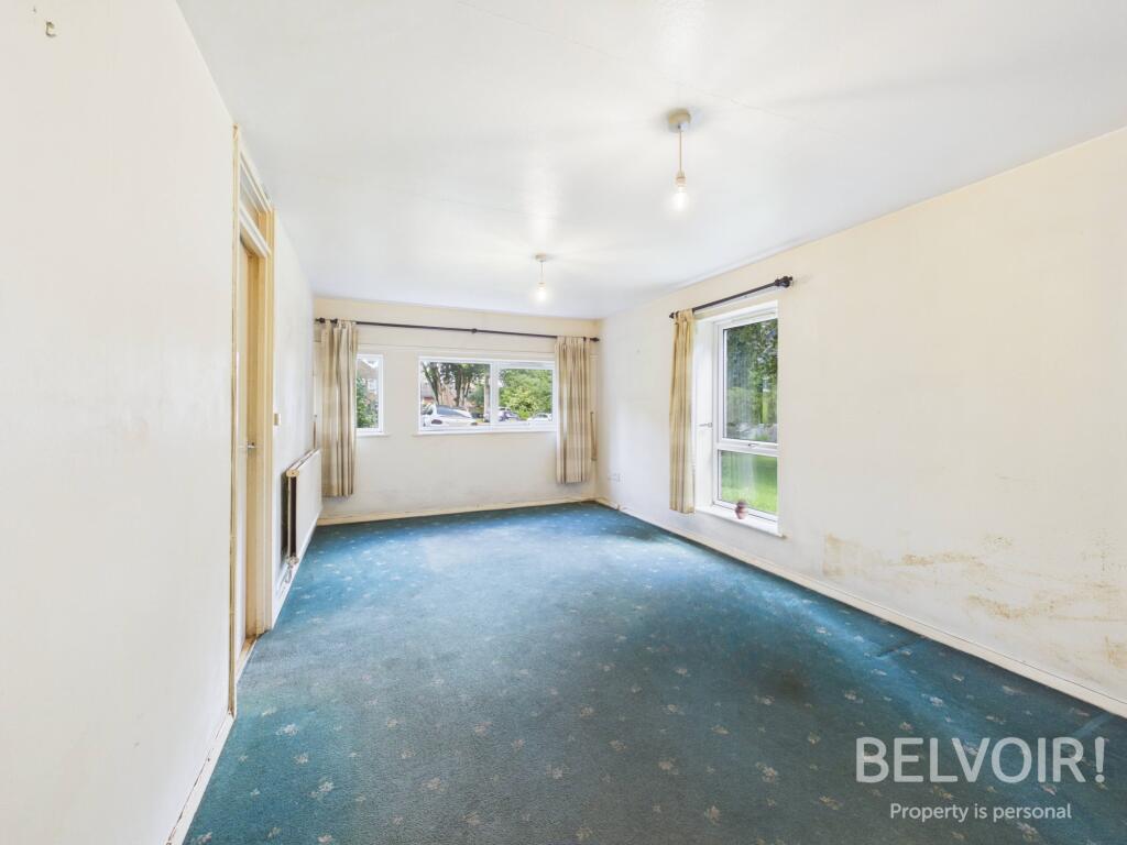
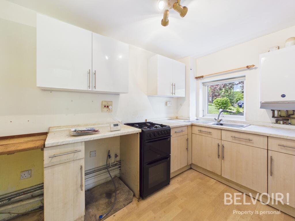
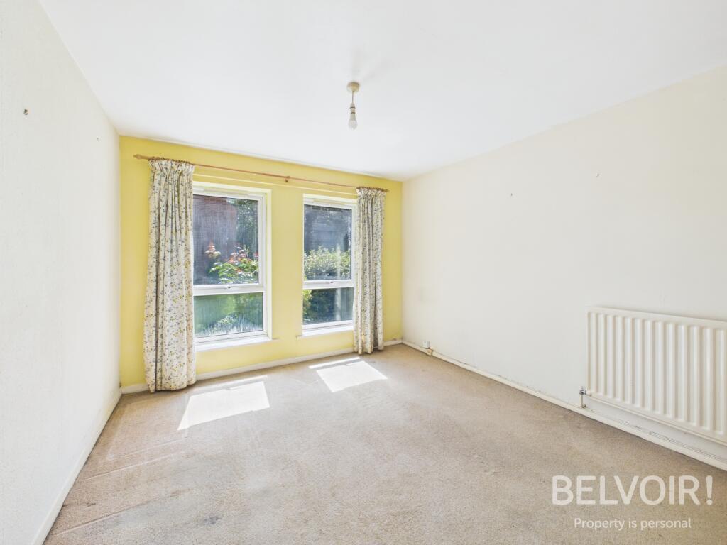
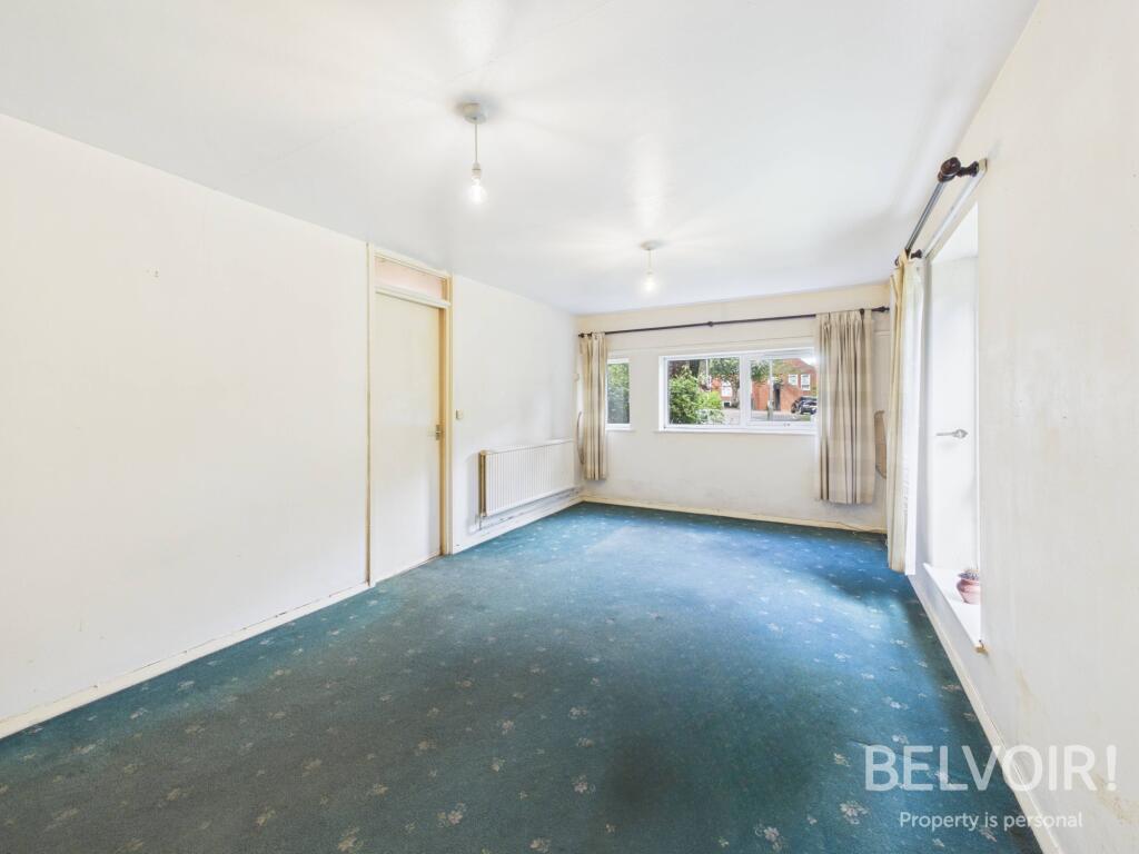
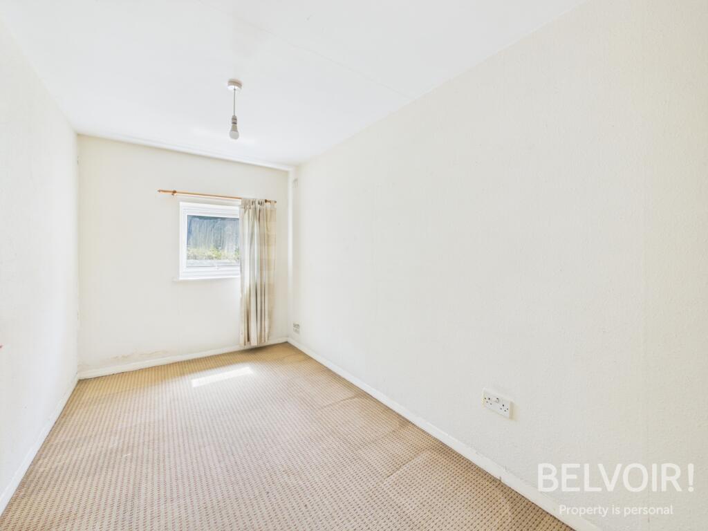
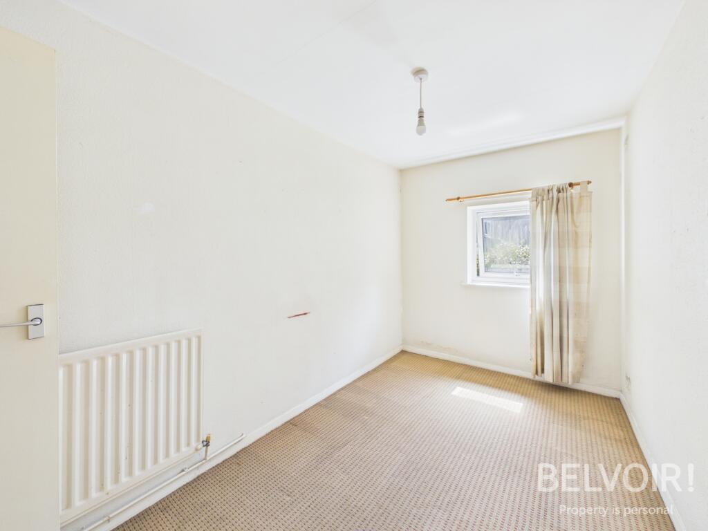
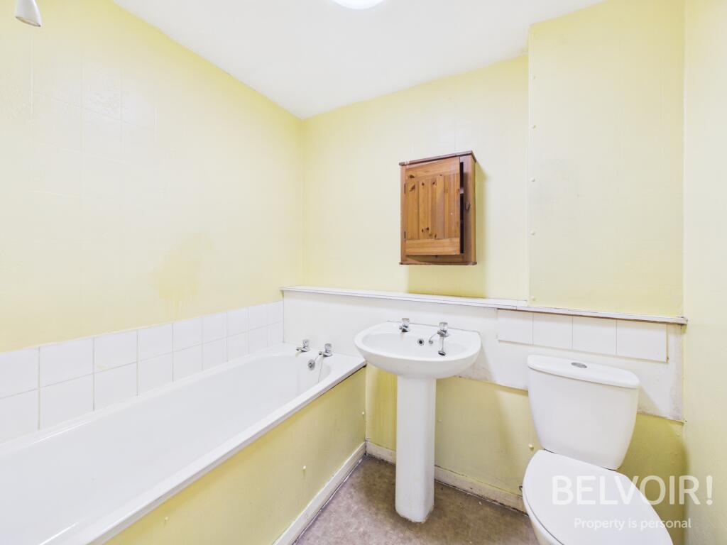
Photo 1 Photo 2 Photo 3 Photo 4 Photo 5 Photo 6 Photo 7 Photo 8
/ 8
Property details
Tenure
LEASEHOLD
Council tax band
A
Local average
£146,600 (-31.8%)
Deprivation
Decile 6 (18,763 of 33,755)
Street crime
96 incidents within 1 mile (Apr 2026)
Key features
- Spacious Ground Floor Flat
- Stone Town Centre Location
- Two Double Bedrooms
- Open Plan Lounge/Diner
- Family Bathroom with Three Piece Suite
- Fitted Kitchen
- Generous Storage Room
- Allocated Parking
- Ideal First Time/Investment Purchase
- No Upward Chain!
Additional details
- Heating
- Gas central
- Parking
- Permit
- Listed property
- No
- Required access
- No
- Rights of way
- Yes
- Flood defences
- No
Description
Accommodation:
Access via a secure entry system
Entrance Hall: With walk in generous storage room
Lounge/Diner: With uPVC double glazed windows to two elevations
Family Bathroom: With bath, pedestal wash hand basin, WC, extractor fan
Fitted Kitchen: With a range of base and wall units, worktops, space for freestanding appliances, uPVC double glazed window to the front
Two Double Bedrooms: Both with uPVC double glazed windows
Externally: Private car park with allocated parking for residents and visitors
EPC Asset Rating: TBC
Viewings: Please contact Belvoir Stone office
Services: All mains services are connected in accordance with normal terms of supply, telephone subject to normal terms and conditions. The gas and electrical appliances mentioned have not been tested by us and purchasers are therefore advised to undertake their own tests should they consider this necessary. All interested parties should obtain verification through their solicitor or surveyor before entering a legal commitment to purchase.
Tenure: Leasehold
Tenure: Leasehold, Planning permissions: not known Mobile signal information: usual providers
Listed by
Stafford
The Property Franchise Group
Reference: 89526318
EPC ratings on this postcode
We don't have a matched EPC for this property yet. Below are efficiency scores and details for other addresses on this postcode.
| Address | Current | Potential | Floor area | Age band | Type |
|---|---|---|---|---|---|
| 20 WALTON GRANGE, STAFFORD ROAD, STONE, STONE | 72 | 80 | 59 m² | England and Wales: 1976-1982 | Flat |
| Flat 16 Walton Grange, Stafford Road, STONE | 74 | 77 | 60 m² | England and Wales: 1983-1990 | Flat |
| Flat 19, Walton Grange, Stafford Road, STONE | 79 | 79 | 65 m² | England and Wales: 1967-1975 | Flat |
| Flat 21 Walton Grange, Stafford Road, STONE | 69 | 75 | 76 m² | England and Wales: 1983-1990 | Flat |
| Flat 23, Walton Grange, STONE | 75 | 77 | 60 m² | England and Wales: 1991-1995 | Flat |
| Flat 24, Walton Grange, Stafford Road, STONE | 71 | 77 | 57 m² | England and Wales: 1991-1995 | Flat |
| Flat 25, Walton Grange, Stafford Road, STONE | 79 | 79 | 60 m² | England and Wales: 1976-1982 | Flat |
| Flat 30 Walton Grange, Stafford Road, STONE | 76 | 78 | 59 m² | England and Wales: 1976-1982 | Flat |
| Flat 32, Walton Grange, Stafford Road, STONE | 76 | 76 | 43 m² | England and Wales: 1967-1975 | Flat |
| Flat 33, Walton Grange, STONE | 76 | 79 | 58 m² | England and Wales: 1983-1990 | Flat |
| Flat 35, Walton Grange, Stafford Road, STONE | 79 | 81 | 60 m² | England and Wales: 1967-1975 | Flat |
| Flat 37, Walton Grange, Stafford Road, STONE | 77 | 77 | 59 m² | England and Wales: 1967-1975 | Flat |
| Flat 38, Walton Grange, Stafford Road, STONE | 79 | 79 | 61 m² | England and Wales: 1967-1975 | Flat |
| Flat 40 Walton Grange, Stafford Road, STONE | 74 | 76 | 60 m² | England and Wales: 1967-1975 | Flat |
| Flat 43, Walton Grange, STONE | 76 | 76 | 60 m² | England and Wales: 1950-1966 | Flat |
Flood risk
Zone: 1
Risk: Low
Job (default Low)
Floorplans
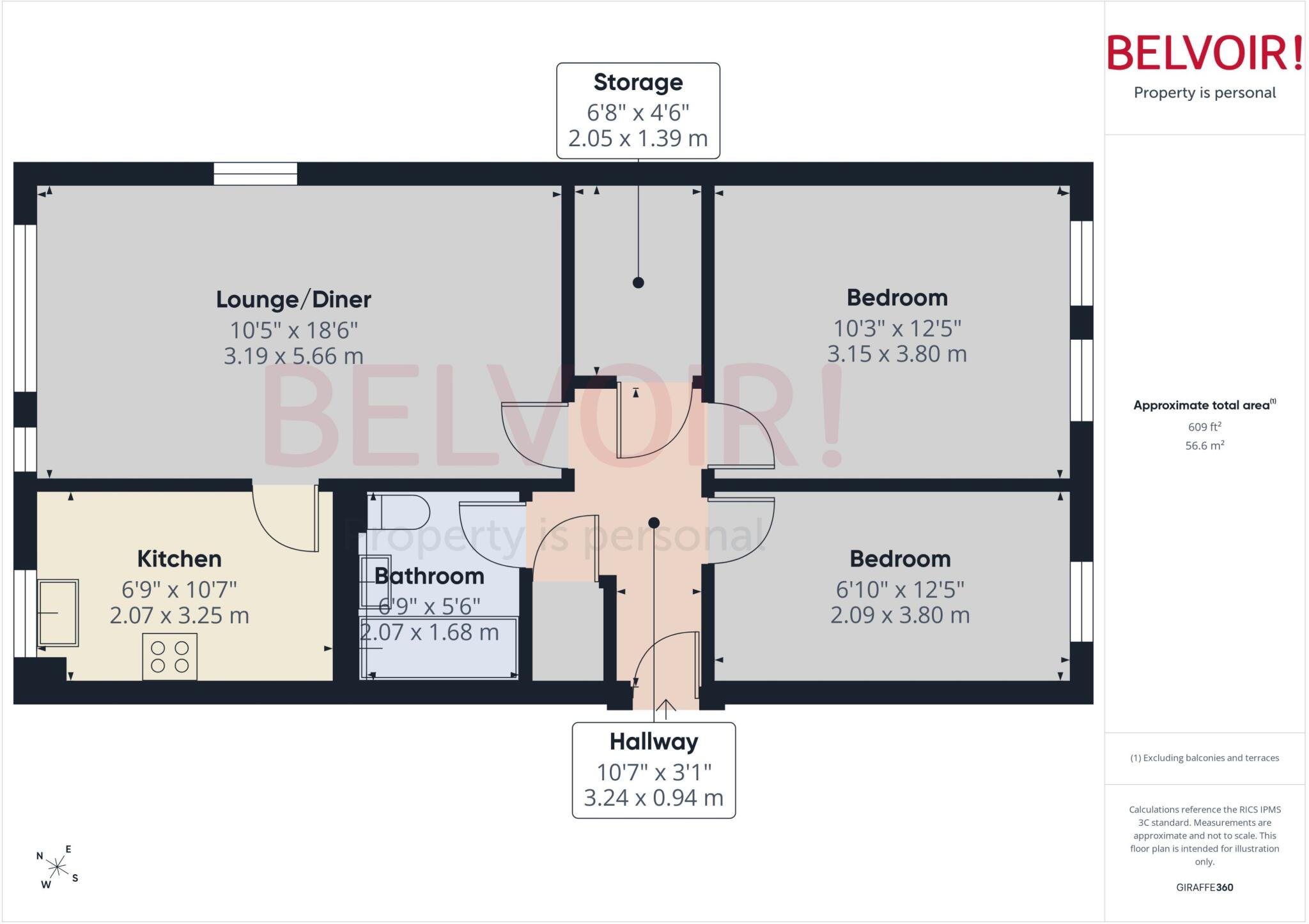
Floorplan
Price history
| Event | Date | Price | % change |
|---|---|---|---|
| Listed for sale | — | £99,950 | — |
Source: HM Land Registry Price Paid Data. Crown copyright.
Sold Comparables
Same street and nearby sales within 0.25 miles (last 5 years). Data from Land Registry Price Paid.
| Address | Price | Date | Type |
|---|---|---|---|
| CROWN MEADOW COURT 7 STAFFORD CLOSE, STONE, STAFFORD, STAFFORDSHIRE, ST15 0GX | £138,000 | 25/08/2023 | Flat |
| Same street WALTON GRANGE FLAT 25 STAFFORD ROAD, STONE, STAFFORD, STAFFORDSHIRE, ST15 0ET | £92,000 | 17/03/2023 | Flat |
| CROWN MEADOW COURT 2 STAFFORD CLOSE, STONE, STAFFORD, STAFFORDSHIRE, ST15 0GX | £160,000 | 28/10/2022 | Flat |
| Same street WALTON GRANGE FLAT 16 STAFFORD ROAD, STONE, STAFFORD, STAFFORDSHIRE, ST15 0ET | £115,000 | 31/03/2022 | Flat |
Street average: £103,500 (2 sales)
Area average: £149,000 (2 sales)
Capital growth trend
Land Registry outcode average: last 12 months vs 5y and 10y ago (from sold prices).
House Price Index (HM Land Registry — official index, not sold-price averages): Stafford. Series: Flats and maisonettes. As of March 2026.
Rental Range
Estimated market rent for Stafford. Low = conservative, Realistic = average, Optimistic = best case.
Based on Local Authority from postcode lookup → Stafford.
LHA (30th percentile) floor for Staffordshire North: £479/mo (Apr 2025 – Mar 2026)
Location
Address
Oultoncross, Stone, Stafford, Staffordshire, England, ST15 0ET, United Kingdom
Nearby
Nearest stations, universities and amenities (distance from property).
| Type | Name | Distance |
|---|---|---|
| Bus stop | Ambulance Station | 0.0 miles |
| Bus stop | Post Office | 0.1 miles |
| Shop | Brydon's Butcher | 0.2 miles |
| Shop | Londis | 0.2 miles |
| Train station | Stone | 0.9 miles |
| Train station | Unknown | 4.5 miles |
| Hospital | Longton Cottage Hospital | 5.7 miles |
| Hospital | St George's Hospital | 6.2 miles |
| University | Staffordshire University Blackheath Lane Site | 6.5 miles |
| University | University of Staffordshire Stoke Campus | 7.8 miles |
Street-level crime
| Category | Count |
|---|---|
| Violence and sexual offences | 43 |
| Anti-social behaviour | 13 |
| Other theft | 9 |
| Shoplifting | 8 |
| Public order | 6 |
| Criminal damage and arson | 5 |
| Burglary | 4 |
| Vehicle crime | 3 |
| Bicycle theft | 1 |
| Drugs | 1 |
| Other crime | 1 |
| Robbery | 1 |
| Theft from the person | 1 |
| Total incidents | 96 |
Within 1 mile during Apr 2026. Source: data.police.uk (England & Wales).
Schools nearby
Nearest open schools with Ofsted ratings (England). Closed schools are not shown. Data from Get Information about Schools and Ofsted.
| Name | Type | Distance | Ofsted |
|---|---|---|---|
| Pirehill First School | Primary | 0.3 miles | Good — 20 Apr 2012 |
| Walton Priory Middle School | Primary | 0.4 miles | Good — 16 Mar 2020 |
| Manor Hill First School | Primary | 0.5 miles | Good — 22 Oct 2012 |
| St Dominic's Catholic Primary School | Primary | 0.5 miles | Outstanding — 22 May 2022 |
| St Michael's CofE (C) First School | Primary | 0.6 miles | Good — 4 Dec 2017 |
Rental Comparables
Loading rental comparables for this postcode. Refresh in a few minutes.
Rent-driven metrics
Based on Area rent estimate.
- Rent ratio — Monthly rent ÷ purchase price (1% rule). 1%+ = strong, 0.8–1% = okay, <0.8% = weak for cashflow.
- Max investor price — Rent ÷ 0.8%; the price at which rent would be 0.8% of price (Stoke-style target).
- Target investor price — Rent ÷ 1%; the price at which rent would be 1% of price (strong cashflow band).
- Gross yield — Annual rent as % of purchase price (no costs).
Enter House Number
Enter the house number to help us retrieve more accurate pricing history and property data.
Please log in to submit or correct the house number for this listing.
Log in to continue