22A
DURSLEY, WOODMANCOTE, GLOUCESTERSHIRE GL11 4AF
£339,500
Property details
Last sold
£330,000 Aug 2006
Local average
£471,138 (-27.9%)
Deprivation
Decile 5 (14,641 of 33,755)
Street crime
1 incident within 1 mile (Apr 2026)
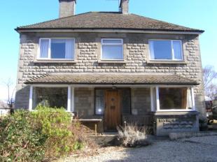
Description
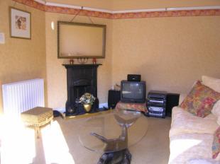
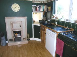
If benefits from four bedrooms, master with en suite, lounge, dining room, family room, kitchen, utility, cloakroom and good size porch to the rear. There are many original features and having been updated by the present owners, now provides central heating.
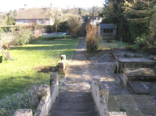
The gardens are of particular note with double wooden gates to the front opening onto gravelled driveway. The rear garden is 100' x 52' with views to the local countryside.
5 Bedrooms Lounge Dining Room Family Room Kitchen Utility/Cloakroom
Cloakroom Rear Porch En-Suite Bathroom Cellar
Listed by
Dursley
Countrywide UK Sales - Connells
Reference: 11429438
EPC Rating & Upgrade Cost
Fetching EPC data… Refresh this page in a moment.
Flood risk
Zone: 1
Risk: Low
Job (default Low)
Floorplans
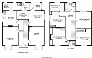
Floorplan
FENSA Certificates
This property has 2 FENSA certificate(s) on record, indicating window/door installations by FENSA-approved installers.
FENSA Certificate #8833632
Property Details
Street: 22a Woodmancote
Town: DURSLEY
Postcode: GL11 4AF
Installation Details
Items: 13 windows
Certificate Issued: 30/04/2012
Work Completed: 18/11/2011
This certificate data was retrieved from FENSA's database
FENSA Certificate #7521031
Property Details
Street: 22a Woodmancote
Town: DURSLEY
Postcode: GL11 4AF
Installation Details
Items: 1 window
Certificate Issued: 27/07/2010
Work Completed: 03/07/2010
This certificate data was retrieved from FENSA's database
What is FENSA? FENSA (Fenestration Self-Assessment Scheme) is a government-authorised scheme that monitors building regulation compliance for replacement windows and doors. Certificates indicate that work was completed by FENSA-approved installers.
Price history
206% since 1998
| Event | Date | Price | % change |
|---|---|---|---|
| Sold | 23/08/2006 (19 years ago) | £330,000 | +205.6% |
| Sold | 15/01/1998 (28 years ago) | £108,000 | — |
Source: HM Land Registry Price Paid Data. Crown copyright.
Sold Comparables
Same street and nearby sales within 0.25 miles (last 5 years). Data from Land Registry Price Paid.
| Address | Price | Date | Type |
|---|---|---|---|
| Same street 8 WOODMANCOTE, DURSLEY, STROUD, GLOUCESTERSHIRE, GL11 4AF | £245,000 | 16/06/2025 | Terraced |
| Same street 33 WOODMANCOTE, DURSLEY, STROUD, GLOUCESTERSHIRE, GL11 4AF | £260,000 | 02/08/2024 | Semi-detached |
| Same street 20A WOODMANCOTE, DURSLEY, STROUD, GLOUCESTERSHIRE, GL11 4AF | £515,000 | 26/04/2024 | Detached |
| Same street 16 WOODMANCOTE, DURSLEY, STROUD, GLOUCESTERSHIRE, GL11 4AF | £320,000 | 26/07/2023 | Terraced |
| Same street 10 WOODMANCOTE, DURSLEY, STROUD, GLOUCESTERSHIRE, GL11 4AF | £226,001 | 27/04/2023 | Terraced |
| 17 BULLPITCH, DURSLEY, STROUD, GLOUCESTERSHIRE, GL11 4NG | £280,000 | 12/10/2022 | Detached |
| Same street 17 WOODMANCOTE, DURSLEY, STROUD, GLOUCESTERSHIRE, GL11 4AF | £415,000 | 08/08/2022 | Semi-detached |
| Same street 4 WOODMANCOTE, DURSLEY, STROUD, GLOUCESTERSHIRE, GL11 4AF | £500,000 | 08/04/2022 | Terraced |
| 5 ST MARKS RISE, WOODMANCOTE, DURSLEY, STROUD, GLOUCESTERSHIRE, GL11 4AN | £375,000 | 25/06/2021 | Detached |
Street average: £354,429 (7 sales)
Area average: £327,500 (2 sales)
Capital growth trend
Land Registry outcode average: last 12 months vs 5y and 10y ago (from sold prices).
House Price Index (HM Land Registry — official index, not sold-price averages): Stroud. Series: Detached. As of March 2026.
Rental Range
Estimated market rent for Stroud. Low = conservative, Realistic = average, Optimistic = best case.
Based on Local Authority from postcode lookup → Stroud.
LHA (30th percentile) floor for Gloucester: £1,197/mo (Apr 2025 – Mar 2026)
Location
Nearby
Nearest stations, universities and amenities (distance from property).
| Type | Name | Distance |
|---|---|---|
| Bus stop | Vizard Close | 0.1 miles |
| Bus stop | Uley Rd | 0.1 miles |
| Shop | Picture Framers | 0.1 miles |
| Shop | Salon 54 | 0.2 miles |
| Train station | Cam and Dursley | 2.7 miles |
| Train station | Stonehouse | 5.5 miles |
| Hospital | Stroud Maternity Hospital | 7.5 miles |
| Hospital | Stroud General Hospital | 7.5 miles |
Street-level crime
| Category | Count |
|---|---|
| Violence and sexual offences | 1 |
| Total incidents | 1 |
Within 1 mile during Apr 2026. Source: data.police.uk (England & Wales).
Schools nearby
Nearest open schools with Ofsted ratings (England). Closed schools are not shown. Data from Get Information about Schools and Ofsted.
| Name | Type | Distance | Ofsted |
|---|---|---|---|
| Dursley Church of England Primary Academy | Primary | 0.4 miles | Good — 22 Apr 2015 |
| Rednock School | Secondary | 0.6 miles | Good — 23 Jan 2024 |
| Peak Academy | Other | 0.6 miles | Inadequate — 26 Sep 2021 |
| Cam Everlands Primary School | Primary | 1.2 miles | Good — 26 Feb 2016 |
| Cam Hopton Church of England Primary School | Primary | 1.2 miles | Good — 15 Jun 2015 |
Rental Comparables
Rental listings exist nearby, but none matched the 5-bedroom count for this property.
Rent-driven metrics
Based on Area rent estimate.
- Rent ratio — Monthly rent ÷ purchase price (1% rule). 1%+ = strong, 0.8–1% = okay, <0.8% = weak for cashflow.
- Max investor price — Rent ÷ 0.8%; the price at which rent would be 0.8% of price (Stoke-style target).
- Target investor price — Rent ÷ 1%; the price at which rent would be 1% of price (strong cashflow band).
- Gross yield — Annual rent as % of purchase price (no costs).