8 ST HUGHS CLOSE
PRENTON, MERSEYSIDE CH43 4YS
£95,000

Property details
Last sold
£93,500 Nov 2018
Local average
£219,282 (-56.7%)
Deprivation
Decile 1 (2,063 of 33,755)
Street crime
542 incidents within 1 mile (Mar 2026)
Key features
- No Chain
- Two Bedrooms
- Gas Central Heating
- Off Road Parkin
- Rear Garden
Additional details
- Parking
- Yes
- Garden
- Yes
Description
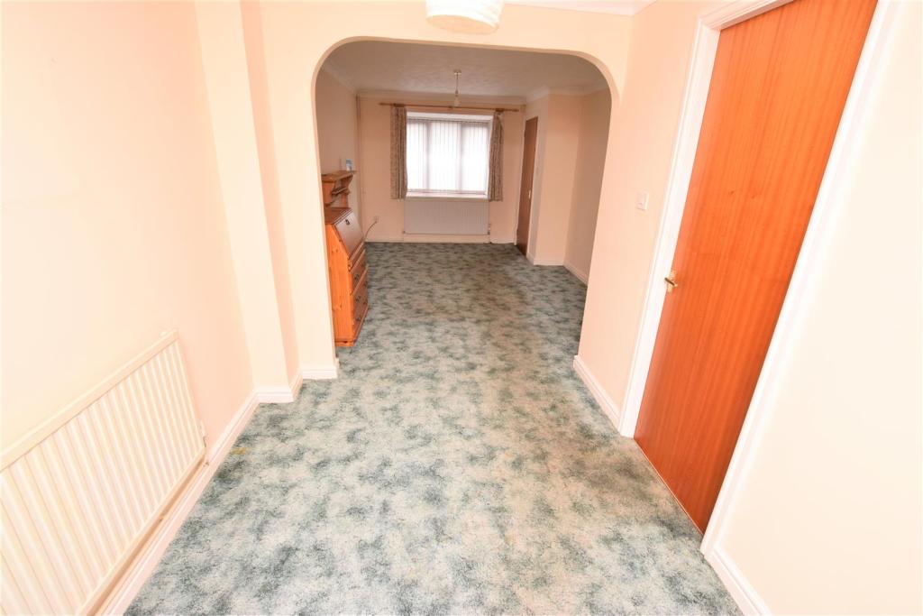
Entrance Hall - Stairs leading to the first floor, radiator and alarm.
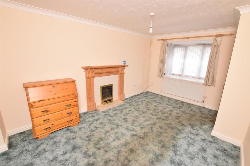
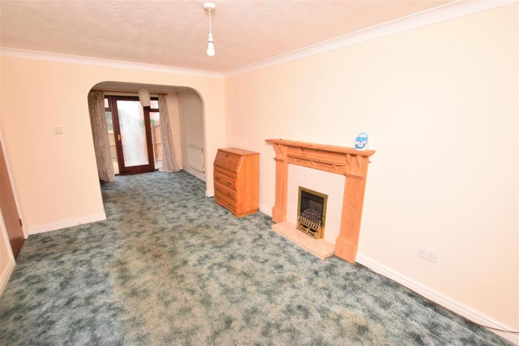
Living Room/Dining Room - 7.19 x 3.09 (23'7" x 10'1") - Gas fire with surround, bay window, storage cupboard, radiators and door leading to the rear.
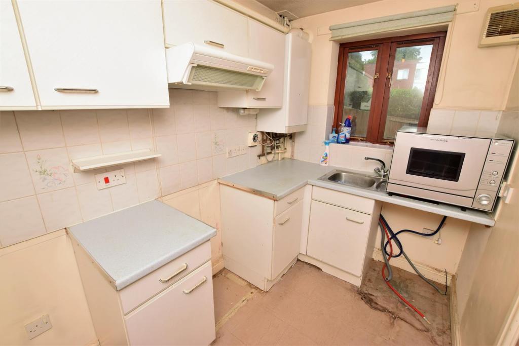
Kitchen - 2.70 x 1.7 (8'10" x 5'6") - variety of storage cupboards, work surface, sink with drainer, boiler, space for washing machine, space for fridge freezer, space for cooker with overhead extractor and window.
First Floor Landing - Loft access and storage cupboard.
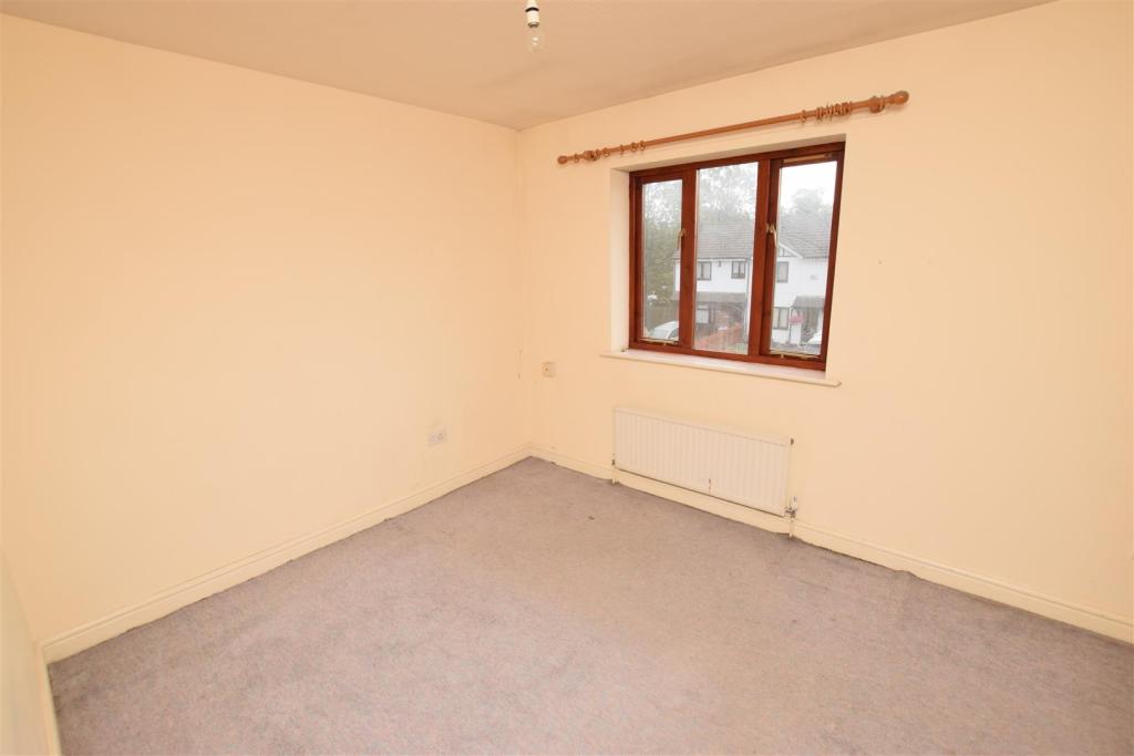
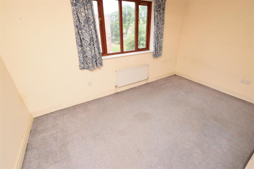
Bedroom One - 4.09 x 2.81 (13'5" x 9'2") - Window with front aspect and radiator.
Bedroom Two - 4.09 x 2.43 (13'5" x 7'11") - window with rear aspect and radiator.
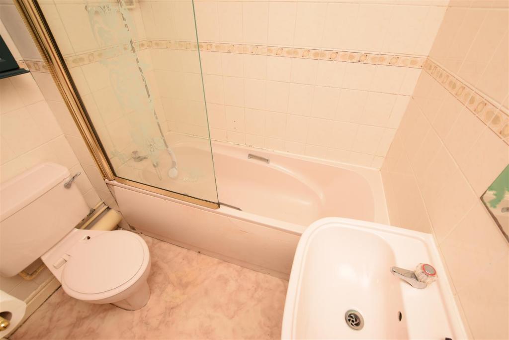
Bathroom - Paneled bath with overhead shower, pedestal sink, low flush w.c, tiled walls and vinyl flooring.
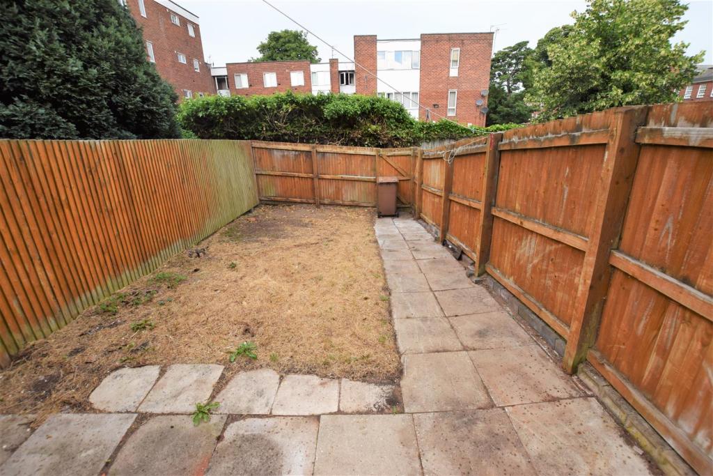
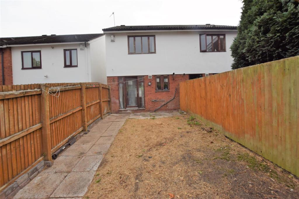
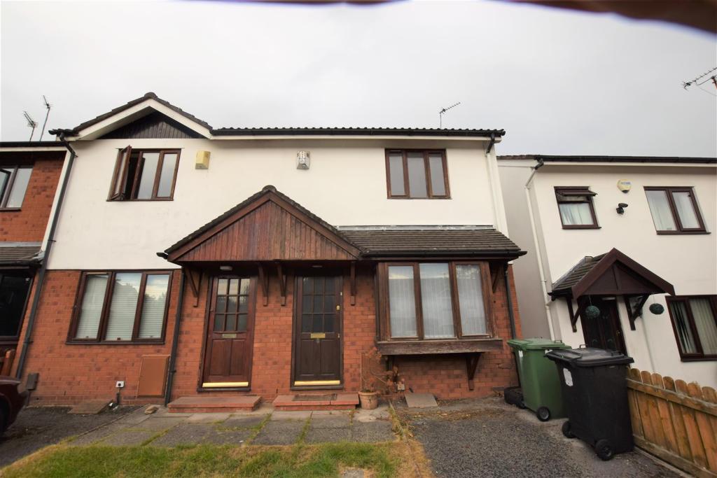
Exterior - Front garden, off road parking and rear garden.
Listed by
Prenton
Vista Abode Ltd
Reference: 66538108
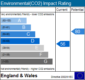
EPC Rating & Upgrade Cost
Fetching EPC data… Refresh this page in a moment.
Flood risk
Zone: 1
Risk: Low
Job (default Low)
Floorplans
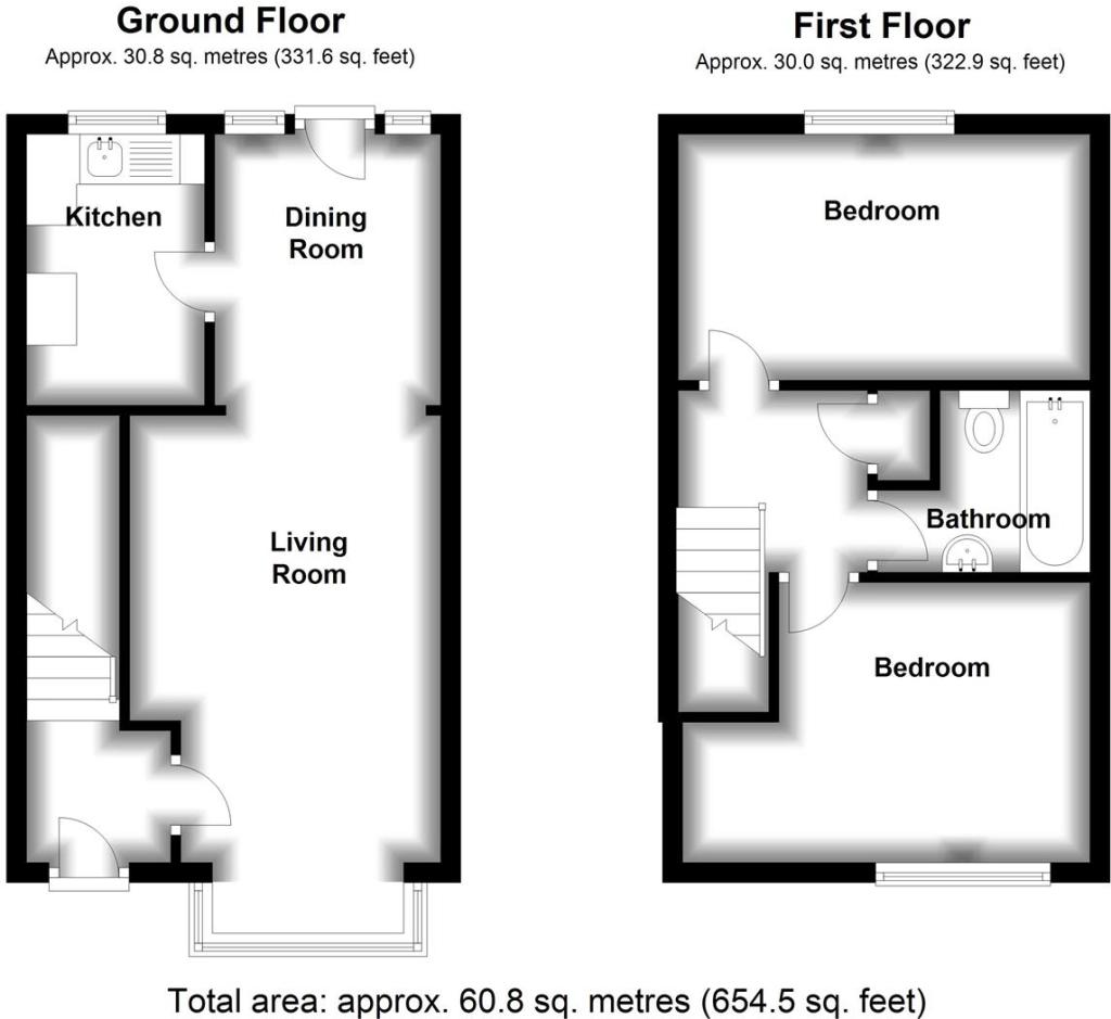
8 Saint Hughs.jpg
EPC Graphs
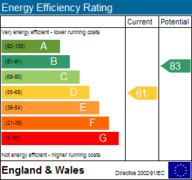
EE Rating
EI Rating
FENSA Certificates
This property has 1 FENSA certificate(s) on record, indicating window/door installations by FENSA-approved installers.
FENSA Certificate #13431490
Property Details
Street: 8 St. Hughs Close
Town: PRENTON
Postcode: CH43 4YS
Installation Details
Items: 4 windows and 2 doors
Certificate Issued: 18/03/2019
Work Completed: 01/02/2019
This certificate data was retrieved from FENSA's database
What is FENSA? FENSA (Fenestration Self-Assessment Scheme) is a government-authorised scheme that monitors building regulation compliance for replacement windows and doors. Certificates indicate that work was completed by FENSA-approved installers.
Price history
| Event | Date | Price | % change |
|---|---|---|---|
| Sold | 14/11/2018 (7 years ago) | £93,500 | — |
Source: HM Land Registry Price Paid Data. Crown copyright.
Sold Comparables
Same street and nearby sales within 0.25 miles (last 5 years). Data from Land Registry Price Paid.
| Address | Price | Date | Type |
|---|---|---|---|
| 59 WEBSTER ROAD, LIVERPOOL, MERSEYSIDE, L7 4LG | £60,000 | 17/12/2025 | Terraced |
| 15 GALLOWAY STREET, LIVERPOOL, MERSEYSIDE, L7 6PD | £90,000 | 08/12/2025 | Terraced |
| 123 ALDERSON ROAD, LIVERPOOL, MERSEYSIDE, L15 1HG | £175,750 | 15/09/2025 | Terraced |
| 26 LISCARD ROAD, LIVERPOOL, MERSEYSIDE, L15 0HH | £150,000 | 15/09/2025 | Terraced |
| 27 SANDHEAD STREET, LIVERPOOL, MERSEYSIDE, L7 6PB | £72,000 | 02/05/2025 | Terraced |
| 108 ALDERSON ROAD, LIVERPOOL, MERSEYSIDE, L15 1HH | £115,000 | 12/02/2025 | Terraced |
| 126 ALDERSON ROAD, LIVERPOOL, MERSEYSIDE, L15 1HH | £207,000 | 21/11/2023 | Terraced |
| 21 CHILDWALL AVENUE, LIVERPOOL, MERSEYSIDE, L15 2JB | £73,000 | 03/11/2023 | Terraced |
| 157 ALDERSON ROAD, LIVERPOOL, MERSEYSIDE, L15 1HG | £197,000 | 02/11/2023 | Terraced |
| 2 BRITANNIA AVENUE, LIVERPOOL, MERSEYSIDE, L15 2JE | £98,000 | 27/10/2023 | Terraced |
| 129 CRANBORNE ROAD, LIVERPOOL, MERSEYSIDE, L15 2HY | £90,000 | 26/10/2023 | Terraced |
| 1 CRANBORNE ROAD, LIVERPOOL, MERSEYSIDE, L15 2HX | £130,000 | 15/09/2023 | Terraced |
| 7 LISCARD ROAD, LIVERPOOL, MERSEYSIDE, L15 0HH | £110,000 | 21/08/2023 | Terraced |
| 23 BRITANNIA AVENUE, LIVERPOOL, MERSEYSIDE, L15 2JE | £110,000 | 15/08/2023 | Terraced |
| 123 ALDERSON ROAD, LIVERPOOL, MERSEYSIDE, L15 1HG | £135,000 | 26/06/2023 | Terraced |
| 48 LISCARD ROAD, LIVERPOOL, MERSEYSIDE, L15 0HH | £160,000 | 09/06/2023 | Terraced |
| 1A DORSET AVENUE, LIVERPOOL, MERSEYSIDE, L15 2JA | £50,000 | 26/05/2023 | Terraced |
| 91 WEBSTER ROAD, LIVERPOOL, MERSEYSIDE, L7 4LG | £68,100 | 24/04/2023 | Terraced |
| 121 WEBSTER ROAD, LIVERPOOL, MERSEYSIDE, L7 4LG | £55,000 | 01/03/2023 | Terraced |
| 33 TABLEY ROAD, LIVERPOOL, MERSEYSIDE, L15 0HJ | £125,000 | 21/12/2022 | Terraced |
Area average: £113,543 (20 sales)
Capital growth trend
Land Registry outcode average: last 12 months vs 5y and 10y ago (from sold prices).
House Price Index (HM Land Registry — official index, not sold-price averages): Wirral. Series: Terraced. As of February 2026.
Rental Range
Estimated market rent for Wirral. Low = conservative, Realistic = average, Optimistic = best case.
Based on Local Authority from postcode lookup → Wirral.
LHA (30th percentile) floor for Wirral: £524/mo (Apr 2025 – Mar 2026)
Location
Nearby
Nearest stations, universities and amenities (distance from property).
| Type | Name | Distance |
|---|---|---|
| Bus stop | LAWRENCE ROAD/CHURCH | 0.1 miles |
| Bus stop | EARLE ROAD/ANNERLEY STREET | 0.1 miles |
| Shop | Babylon store | 0.2 miles |
| Shop | Liver Launderettes | 0.3 miles |
| Train station | Edge Hill | 0.4 miles |
| Hospital | Greenbank Drive Surgery | 0.7 miles |
| Train station | Wavertree Technology Park | 0.8 miles |
| Hospital | Rathbone Hospital | 1.2 miles |
| University | Liverpool Hope University | 2.0 miles |
| University | Edge Hill University | 11.4 miles |
Street-level crime
| Category | Count |
|---|---|
| Violence and sexual offences | 223 |
| Public order | 54 |
| Other theft | 45 |
| Anti-social behaviour | 44 |
| Criminal damage and arson | 38 |
| Drugs | 37 |
| Shoplifting | 36 |
| Vehicle crime | 20 |
| Burglary | 15 |
| Other crime | 10 |
| Bicycle theft | 9 |
| Possession of weapons | 5 |
| Robbery | 5 |
| Theft from the person | 1 |
| Total incidents | 542 |
Within 1 mile during Mar 2026. Source: data.police.uk (England & Wales).
Schools nearby
Nearest open schools with Ofsted ratings (England). Closed schools are not shown. Data from Get Information about Schools and Ofsted.
| Name | Type | Distance | Ofsted |
|---|---|---|---|
| St Hugh's Catholic Primary School | Primary | 0.0 miles | Requires improvement — 7 Mar 2023 |
| Chatham Place Nursery School | Nursery | 0.1 miles | Good — 5 Dec 2012 |
| Archbishop Blanch CofE High School | Secondary | 0.2 miles | Outstanding — 18 Mar 2020 |
| Lawrence Community Primary School | Primary | 0.3 miles | Good — 21 Sep 2022 |
| St Clare's Catholic Primary School | Primary | 0.4 miles | Good — 17 Dec 2020 |
Rental Comparables
Residential lets from OpenRent and Rightmove for the area (same bedroom count). Use to validate rent estimates. Student lets are excluded.
| Title | Rent | Beds | Distance | As seen on |
|---|---|---|---|---|
| 2 Bed Terraced House, Harrowby Road, CH42 | £775/mo | 2 | 3.86 miles | OpenRent |
| 2 Bed Terraced House, Claughton Place, CH41 | £800/mo | 2 | 3.9 miles | OpenRent |
| 2 Bed Flat, Euston Grove, CH43 | £800/mo | 2 | 4.13 miles | OpenRent |
| 2 Bed Flat, Park Road South, CH43 | £765/mo | 2 | 4.25 miles | OpenRent |
| 2 Bed Flat, Devonshire Road, CH43 | £2,673/mo | 2 | 4.34 miles | OpenRent |
| 2 Bed Flat, Oakland Court, CH43 | £800/mo | 2 | 4.52 miles | OpenRent |
| 2 Bed Flat, Mallaby Court, CH41 | £695/mo | 2 | 4.52 miles | OpenRent |
| 2 Bed Terraced House, Falkland St, CH41 | £800/mo | 2 | 4.67 miles | OpenRent |
Average rent: £1,014/mo (8 listings)
Rent-driven metrics
Based on OpenRent comparables.
- Rent ratio — Monthly rent ÷ purchase price (1% rule). 1%+ = strong, 0.8–1% = okay, <0.8% = weak for cashflow.
- Max investor price — Rent ÷ 0.8%; the price at which rent would be 0.8% of price (Stoke-style target).
- Target investor price — Rent ÷ 1%; the price at which rent would be 1% of price (strong cashflow band).
- Gross yield — Annual rent as % of purchase price (no costs).
- Cost-to-rent — Price ÷ annual rent (from OpenRent comparables). Under 14× = strong, 14–16× = acceptable, 17×+ = compressed.
- Cashflow — Rent minus mortgage, 10% maintenance, £25/mo compliance. Assumes 75% LTV, 3.95% APR (5yr fixed), 25yr term.
- ROI — Annual profit ÷ cash in (deposit + 4% purchase costs).