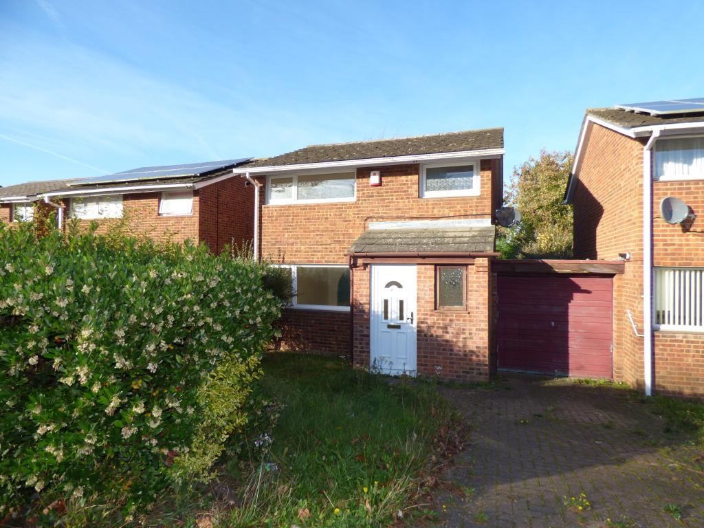
25 SPENCER
MILTON KEYNES, STANTONBURY, MILTON KEYNES MK14 6BQ
Property details
Tenure
FREEHOLD
Floor area
64 m²
EPC rating
C
Year built
England and Wales: 1991-1995
Last sold
£222,000 Mar 2018
Price per m²
£3,516/m²
Local average
£535,036 (-57.9%)
Deprivation
Decile 5 (13,642 of 33,755)
Street crime
133 incidents within 1 mile (Apr 2026)
Key features
- Link Detached
- Three Good Size Bedrooms
- Two Reception Rooms
- Garage
- No Onward Chain
- Great Location
Additional details
- Parking
- Yes
- Garden
- Yes
Description
Ideally located within close proximity to local amenities and Central Milton Keynes.
Listed by
Milton Keynes
Countrywide UK Sales - Connells
Reference: 51536244
EPC Rating & Upgrade Cost
Current rating: C
Potential rating: B
Inspection date: 10/02/2014
Current heating cost: £434/year
Potential heating cost: £401/year
Est. upgrade cost to C: £17,555
Recommendations
- Floor insulation (£800 - £1,200)
- Low energy lighting for all fixed outlets (£55)
- Solar water heating (£4,000 - £6,000)
- Solar photovoltaic panels, 2.5 kWp (£9,000 - £14,000)
Flood risk
Zone: 1
Risk: Low
Job (default Low)
Floorplans
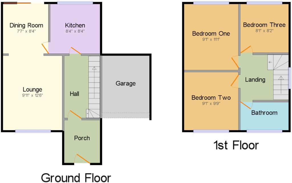
CWQuickSketch.jpg
EPC Graphs
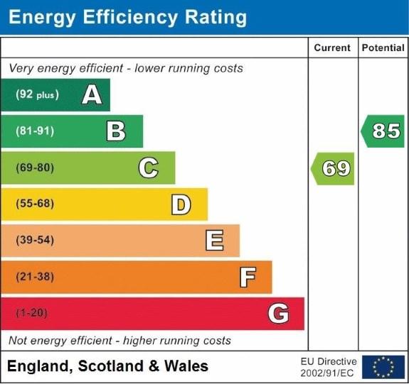
EPC.jpg

EPC
Price history
31% since 2007
| Event | Date | Price | % change |
|---|---|---|---|
| Sold | 16/03/2018 (8 years ago) | £222,000 | +16.8% |
| Sold | 20/06/2014 (11 years ago) | £190,000 | +11.8% |
| Sold | 28/09/2007 (18 years ago) | £170,000 | — |
Source: HM Land Registry Price Paid Data. Crown copyright.
Sold Comparables
Same street and nearby sales within 0.25 miles (last 5 years). Data from Land Registry Price Paid.
| Address | Price | Date | Type |
|---|---|---|---|
| 9 HERDWYCK CLOSE, OAKRIDGE PARK, MILTON KEYNES, MK14 6GR | £525,000 | 02/12/2025 | Detached |
| Same street 9 SPENCER, STANTONBURY, MILTON KEYNES, MK14 6BQ | £290,000 | 29/05/2024 | Detached |
| 2 MELTON, STANTONBURY, MILTON KEYNES, MK14 6BH | £330,000 | 06/11/2023 | Detached |
| Same street 2 SPENCER, STANTONBURY, MILTON KEYNES, MK14 6BQ | £327,000 | 01/03/2023 | Detached |
| 10 CHEVIOT GARDENS, OAKRIDGE PARK, MILTON KEYNES, MK14 6FZ | £525,000 | 22/07/2022 | Detached |
| 8 ARKWRIGHT MEWS, OAKRIDGE PARK, MILTON KEYNES, MK14 6FT | £585,000 | 21/10/2021 | Detached |
| 29 WOOLPACK GRANGE, OAKRIDGE PARK, MILTON KEYNES, MK14 6GP | £425,000 | 18/08/2021 | Detached |
| 22 ASHFIELD, STANTONBURY, MILTON KEYNES, MK14 6AU | £261,000 | 30/06/2021 | Detached |
| 2 KAY GROVE, OAKRIDGE PARK, MILTON KEYNES, MK14 6FY | £339,995 | 28/06/2021 | Detached |
| 10 WINCHCOMBE MEADOWS, OAKRIDGE PARK, MILTON KEYNES, MK14 6GA | £437,500 | 25/06/2021 | Detached |
Street average: £308,500 (2 sales)
Area average: £428,562 (8 sales)
Capital growth trend
Land Registry outcode average: last 12 months vs 5y and 10y ago (from sold prices).
House Price Index (HM Land Registry — official index, not sold-price averages): Milton Keynes. Series: Detached. As of March 2026.
Rental Range
Estimated market rent for Milton Keynes. Low = conservative, Realistic = average, Optimistic = best case.
Based on Local Authority from postcode lookup → Milton Keynes.
LHA (30th percentile) floor for Milton Keynes: £1,192/mo (Apr 2025 – Mar 2026)
Location
Nearby
Nearest stations, universities and amenities (distance from property).
| Type | Name | Distance |
|---|---|---|
| Bus stop | Lincoln | 0.0 miles |
| Bus stop | Spencer | 0.1 miles |
| Shop | Aldi | 0.3 miles |
| Shop | TATA Convenience Store | 0.5 miles |
| Train station | Wolverton | 1.4 miles |
| University | University of Bedfordshire Milton Keynes Campus | 2.0 miles |
| Hospital | Willen Hospice | 2.2 miles |
| Train station | Milton Keynes Central | 2.3 miles |
| Hospital | PJ Care Mallard House Neurological Care Centre | 3.4 miles |
| University | Cranfield University | 6.1 miles |
Street-level crime
| Category | Count |
|---|---|
| Violence and sexual offences | 51 |
| Other theft | 20 |
| Vehicle crime | 17 |
| Shoplifting | 11 |
| Anti-social behaviour | 9 |
| Criminal damage and arson | 9 |
| Burglary | 6 |
| Public order | 6 |
| Bicycle theft | 1 |
| Drugs | 1 |
| Other crime | 1 |
| Theft from the person | 1 |
| Total incidents | 133 |
Within 1 mile during Apr 2026. Source: data.police.uk (England & Wales).
Schools nearby
Nearest open schools with Ofsted ratings (England). Closed schools are not shown. Data from Get Information about Schools and Ofsted.
| Name | Type | Distance | Ofsted |
|---|---|---|---|
| Wood End Infant & Pre-School | Primary | 0.3 miles | Good — 4 Sep 2012 |
| Stanton School | Primary | 0.4 miles | Outstanding — 13 Apr 2016 |
| Stantonbury School | Secondary | 0.4 miles | Requires improvement — 4 Mar 2024 |
| Stephenson Academy | Other | 0.4 miles | Good — 20 Jan 2019 |
| The Webber Independent School | Other | 0.5 miles | — (No rating) |
Rental Comparables
Rental listings exist nearby, but none matched the 3-bedroom count for this property.
Rent-driven metrics
Based on Area rent estimate.
- Rent ratio — Monthly rent ÷ purchase price (1% rule). 1%+ = strong, 0.8–1% = okay, <0.8% = weak for cashflow.
- Max investor price — Rent ÷ 0.8%; the price at which rent would be 0.8% of price (Stoke-style target).
- Target investor price — Rent ÷ 1%; the price at which rent would be 1% of price (strong cashflow band).
- Gross yield — Annual rent as % of purchase price (no costs).