Springfields
Prestbury, SK10 4DW
£895,000
Property details
Tenure
FREEHOLD
Local average
£1,415,975 (-36.8%)
Deprivation
Decile 9 (28,414 of 33,755)
Street crime
10 incidents within 1 mile (Apr 2026)
Additional details
- Parking
- Yes
Description
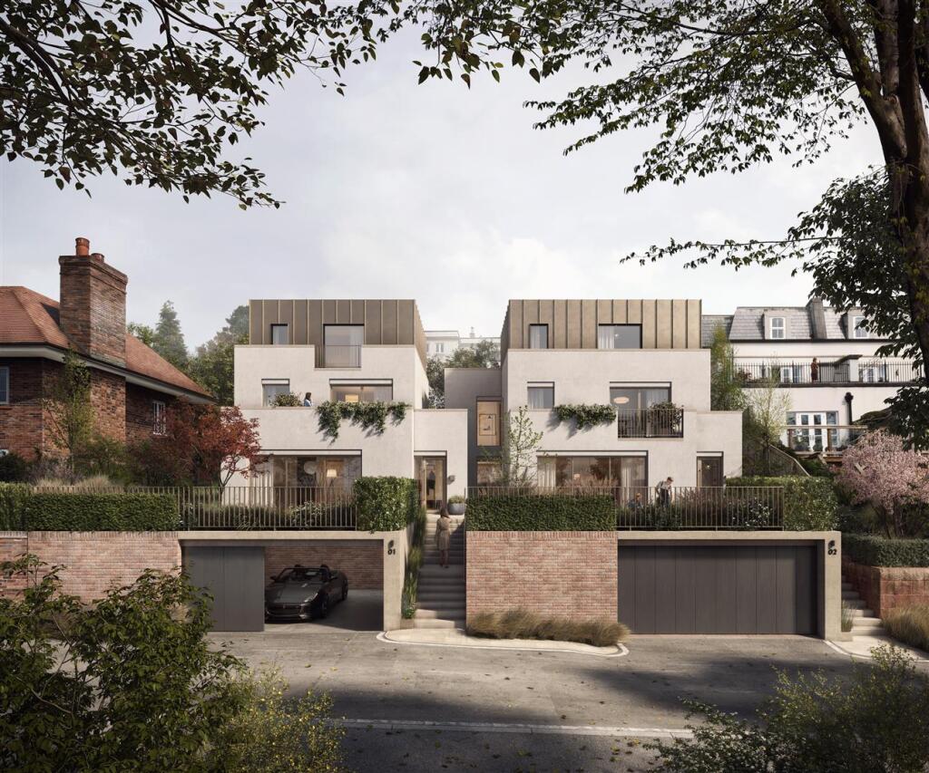
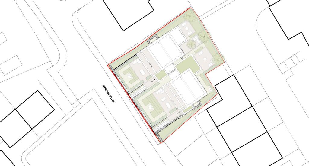
A fantastic opportunity to acquire a development site for two contemporary homes, within walking distance of Prestbury village centre.
The properties will be approximately 2700sqft TBC, excluding the double garage.
Planning reference: 23/1056M
Listed by
Prestbury
Holmes Naden (Estates) Ltd
Reference: 160162124
EPC ratings on this postcode
We don't have a matched EPC for this property yet. Below are efficiency scores and details for other addresses on this postcode.
| Address | Current | Potential | Floor area | Age band | Type |
|---|---|---|---|---|---|
| 1, Springfields, Prestbury | 66 | 88 | 44 m² | England and Wales: 1950-1966 | Bungalow |
| 1, Springfields, Prestbury | 65 | 85 | 44 m² | England and Wales: 1950-1966 | Bungalow |
| 1, Springfields, Prestbury, MACCLESFIELD | 66 | 88 | 44 m² | England and Wales: 1950-1966 | Terraced |
| 1, Springfields, Prestbury, MACCLESFIELD | 65 | 85 | 44 m² | England and Wales: 1950-1966 | Detached |
| 2 Springfield, Prestbury Macclesfield | 50 | 68 | 49 m² | England and Wales: 1950-1966 | Bungalow |
| 2 Springfield, Prestbury Macclesfield | 50 | 68 | 49 m² | England and Wales: 1950-1966 | Detached |
| 3, Springfields, Prestbury | 64 | 86 | 50 m² | England and Wales: 1950-1966 | Bungalow |
| 3, Springfields, Prestbury, MACCLESFIELD | 64 | 86 | 50 m² | England and Wales: 1950-1966 | Terraced |
| 4, Springfields, Prestbury | 69 | 90 | 38 m² | England and Wales: 1950-1966 | Bungalow |
| 4, Springfields, Prestbury, MACCLESFIELD | 69 | 90 | 38 m² | England and Wales: 1950-1966 | Terraced |
| 5, Springfields, Prestbury | 68 | 90 | 38 m² | England and Wales: 1950-1966 | Bungalow |
| 5, Springfields, Prestbury | 65 | 85 | 42 m² | England and Wales: 1950-1966 | Bungalow |
| 5, Springfields, Prestbury, MACCLESFIELD | 68 | 90 | 38 m² | England and Wales: 1950-1966 | Terraced |
| 5, Springfields, Prestbury, MACCLESFIELD | 65 | 85 | 42 m² | England and Wales: 1950-1966 | Terraced |
| 6 Springfield Prestbury, Macclesfield | 64 | 85 | 43 m² | England and Wales: 1950-1966 | Bungalow |
Flood risk
Zone: 1
Risk: Low
Job (default Low)
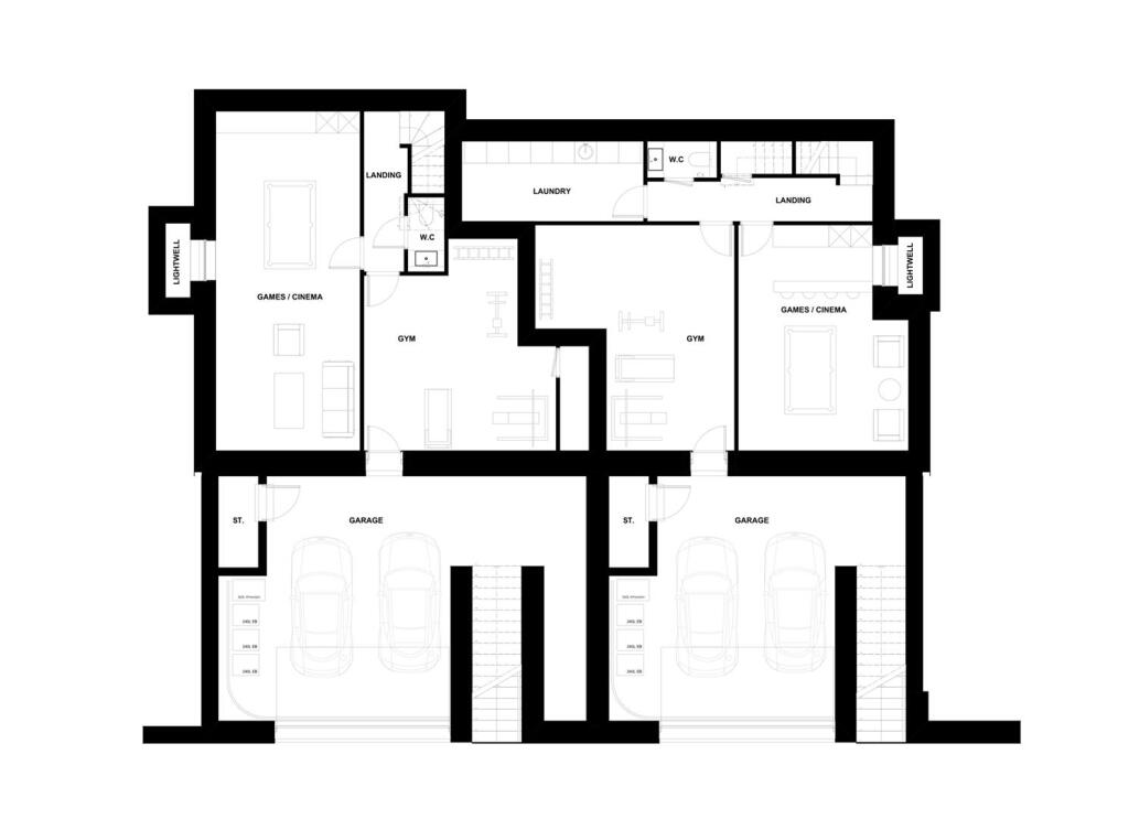
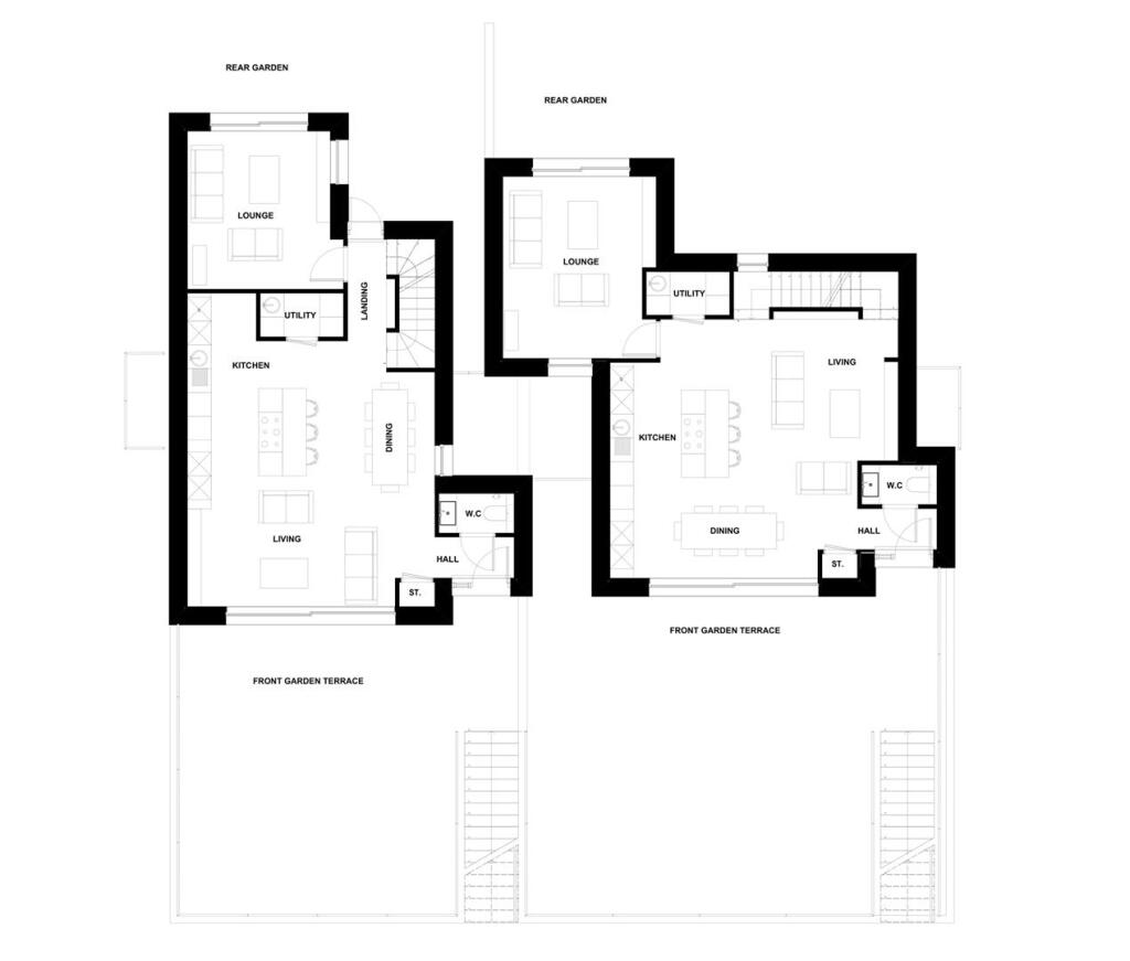
Floorplans
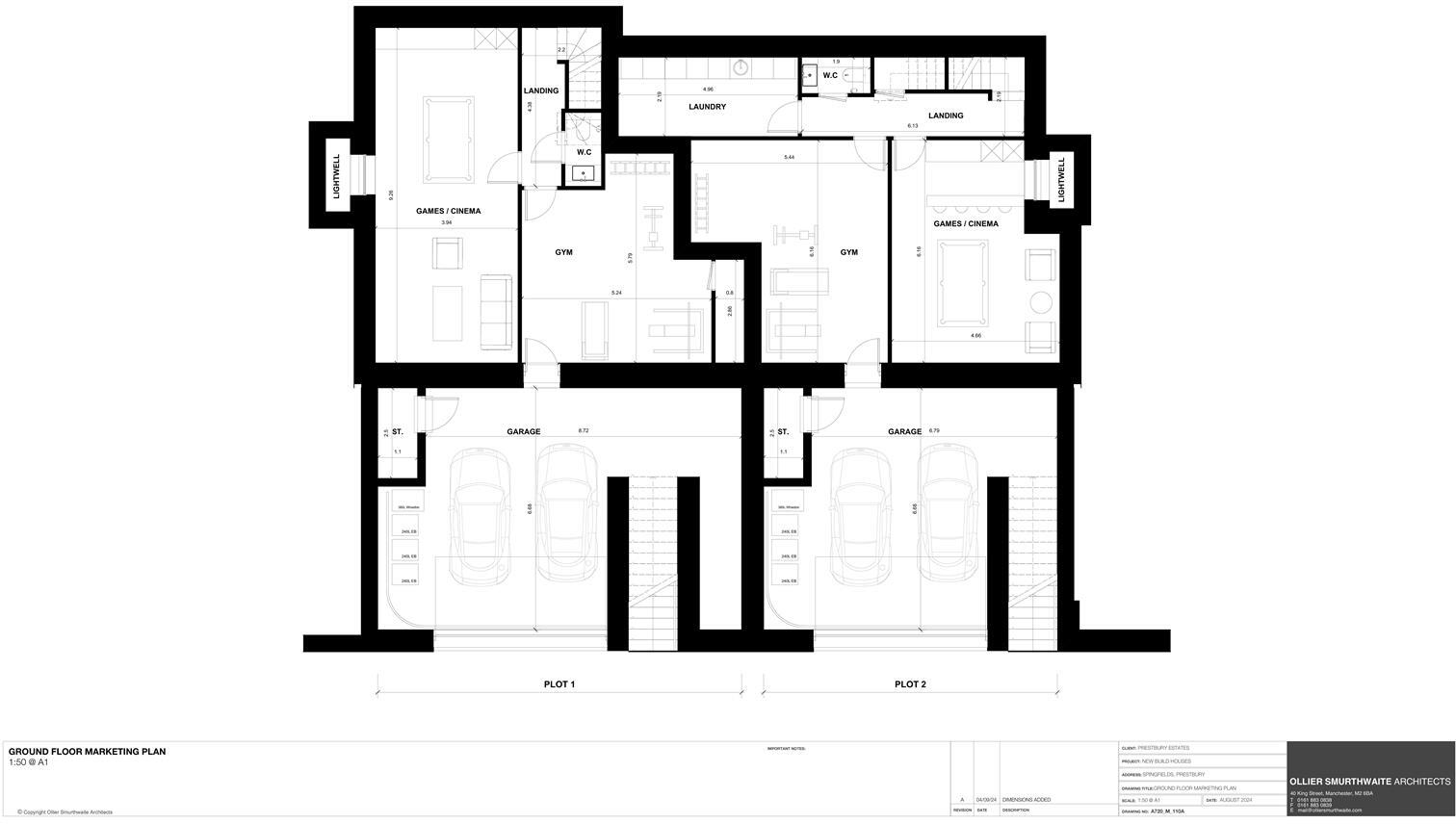
A720_M_110A_GROUND FLOOR MARKETING PLAN .jpg
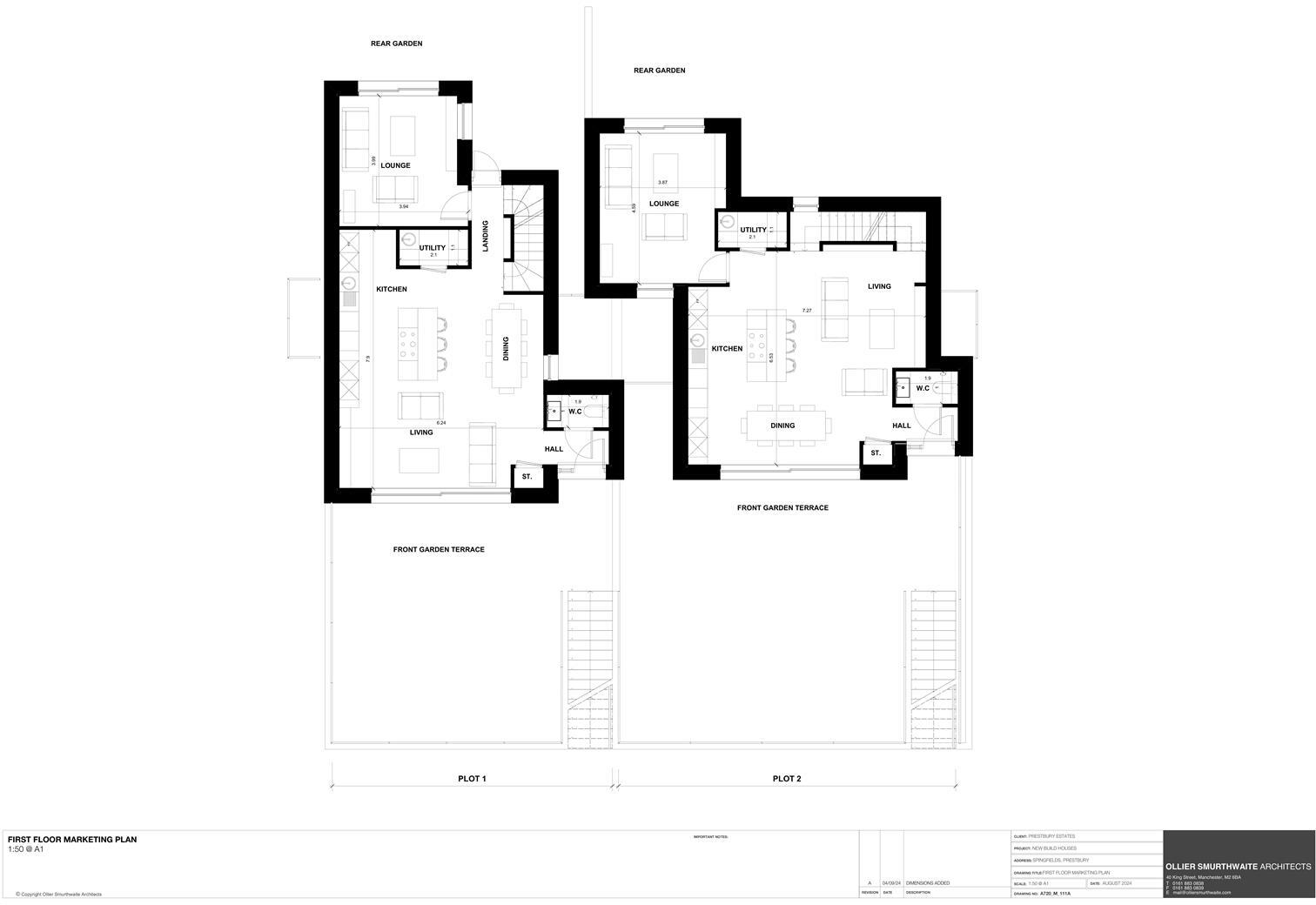
A720_M_111A_FIRST FLOOR MARKETING PLAN .jpg
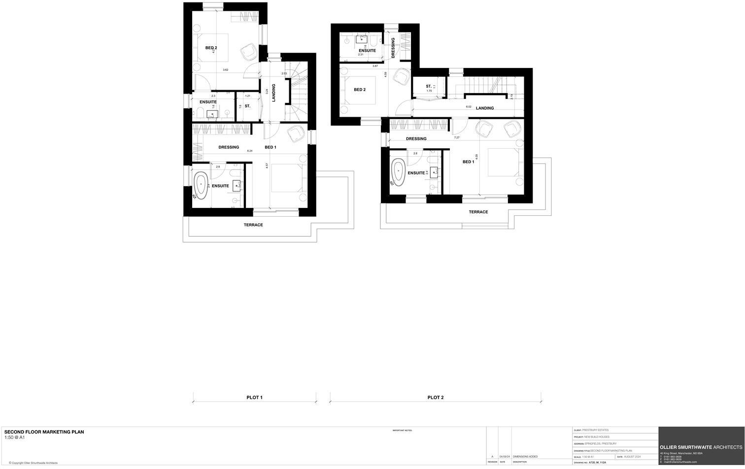
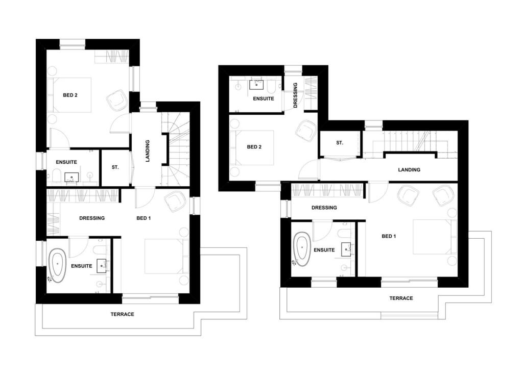
A720_M_112A_SECOND FLOOR MARKETING PLAN .jpg
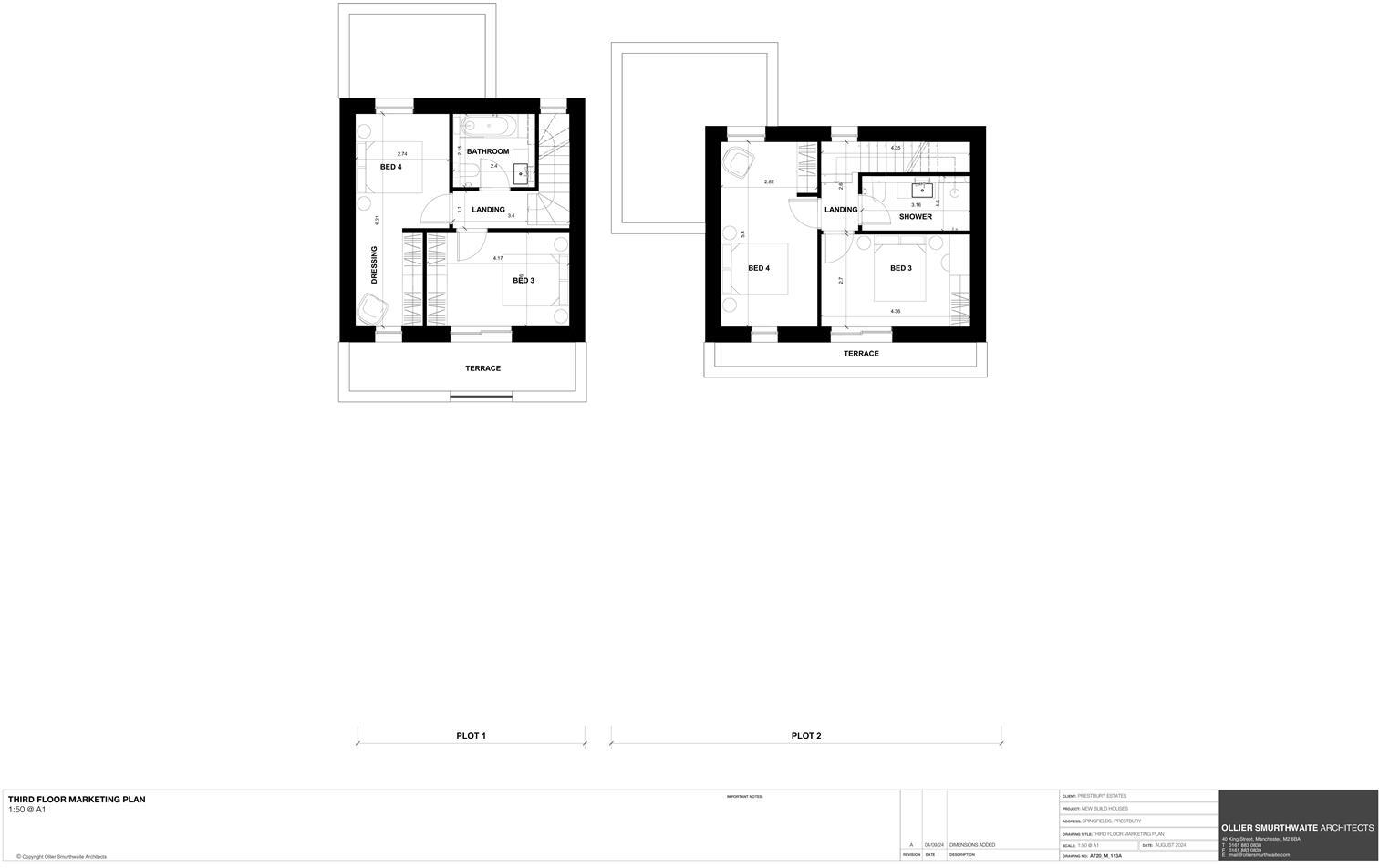
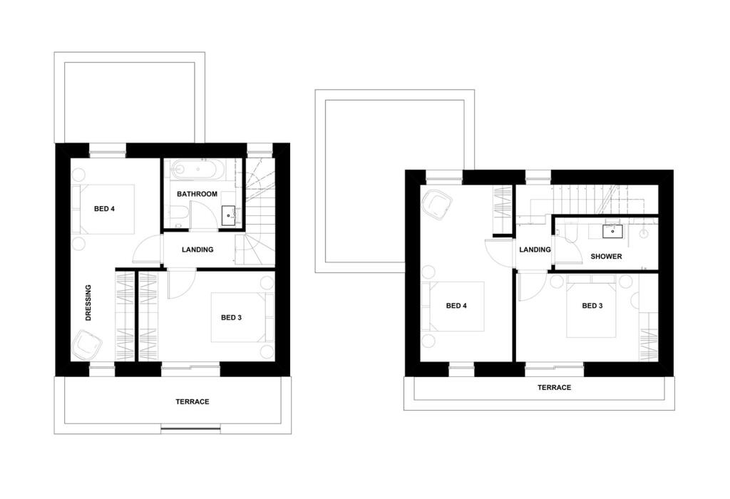
A720_M_113A_THIRD FLOOR MARKETING PLAN (1).jpg
Price history
No sales history found for this property in Land Registry Price Paid data.
Sold Comparables
Same street and nearby sales within 0.25 miles (last 5 years). Data from Land Registry Price Paid.
| Address | Price | Date | Type |
|---|---|---|---|
| ST. JAMES HOUSE NEW ROAD, PRESTBURY, MACCLESFIELD, CHESHIRE EAST, SK10 4HP | £360,000 | 10/08/2022 | Other |
| LOW BARN BRIDGE END DRIVE, PRESTBURY, MACCLESFIELD, CHESHIRE EAST, SK10 4DL | £10,000 | 09/08/2022 | Other |
| BEVERLEY COTTAGE SCOTT ROAD, PRESTBURY, MACCLESFIELD, CHESHIRE EAST, SK10 4DN | £1,750,000 | 12/07/2022 | Other |
| ARTIZANA THE VILLAGE, PRESTBURY, MACCLESFIELD, CHESHIRE EAST, SK10 4DG | £250,000 | 25/02/2022 | Other |
| ARTIZANA SUITE THE VILLAGE, PRESTBURY, MACCLESFIELD, CHESHIRE EAST, SK10 4DG | £285,000 | 25/02/2022 | Other |
Area average: £531,000 (5 sales)
Capital growth trend
Land Registry outcode average: last 12 months vs 5y and 10y ago (from sold prices).
House Price Index (HM Land Registry — official index, not sold-price averages): Cheshire East. Series: All dwelling types. As of March 2026.
Rental Range
Estimated market rent for Cheshire East. Low = conservative, Realistic = average, Optimistic = best case.
Based on Local Authority from postcode lookup → Cheshire East.
LHA (30th percentile) floor for East Cheshire: Apr 2025 – Mar 2026
Location
Address
Springfields
Nearby
Nearest stations, universities and amenities (distance from property).
| Type | Name | Distance |
|---|---|---|
| Bus stop | Prestbury, New Road / Bridge Green | 0.1 miles |
| Shop | Victor Alan | 0.1 miles |
| Shop | Dress Cheshire | 0.1 miles |
| Train station | Prestbury | 0.2 miles |
| Train station | Adlington (Cheshire) | 2.1 miles |
| Hospital | Macclesfield District General Hospital | 2.1 miles |
| Hospital | Rosemount Resource Centre | 2.2 miles |
| University | University of Derby, Buxton | 9.9 miles |
| University | University of Manchester Fallowfield Campus | 10.9 miles |
Street-level crime
| Category | Count |
|---|---|
| Violence and sexual offences | 5 |
| Anti-social behaviour | 1 |
| Drugs | 1 |
| Other theft | 1 |
| Public order | 1 |
| Robbery | 1 |
| Total incidents | 10 |
Within 1 mile during Apr 2026. Source: data.police.uk (England & Wales).
Schools nearby
Nearest open schools with Ofsted ratings (England). Closed schools are not shown. Data from Get Information about Schools and Ofsted.
| Name | Type | Distance | Ofsted |
|---|---|---|---|
| Prestbury CofE Primary School | Primary | 0.1 miles | Good — 12 May 2020 |
| The King's School In Macclesfield | Other | 1.2 miles | — (No rating) |
| Bollington Cross CofE Primary School | Primary | 1.3 miles | Good — 20 Mar 2023 |
| Upton Priory School | Primary | 1.4 miles | Good — 28 Jan 2015 |
| Dean Valley Community Primary School | Primary | 1.4 miles | Good — 1 Nov 2012 |
Rental Comparables
Loading rental comparables for this postcode. Refresh in a few minutes.
Rent-driven metrics
Based on Area rent estimate.
- Rent ratio — Monthly rent ÷ purchase price (1% rule). 1%+ = strong, 0.8–1% = okay, <0.8% = weak for cashflow.
- Max investor price — Rent ÷ 0.8%; the price at which rent would be 0.8% of price (Stoke-style target).
- Target investor price — Rent ÷ 1%; the price at which rent would be 1% of price (strong cashflow band).
- Gross yield — Annual rent as % of purchase price (no costs).
Enter House Number
Enter the house number to help us retrieve more accurate pricing history and property data.
Please log in to submit or correct the house number for this listing.
Log in to continue