FLAT 1
76 - 82, CADOGAN SQUARE, LONDON, LONDON, GREATER LONDON SW1X 0EA
£13,000 pcm
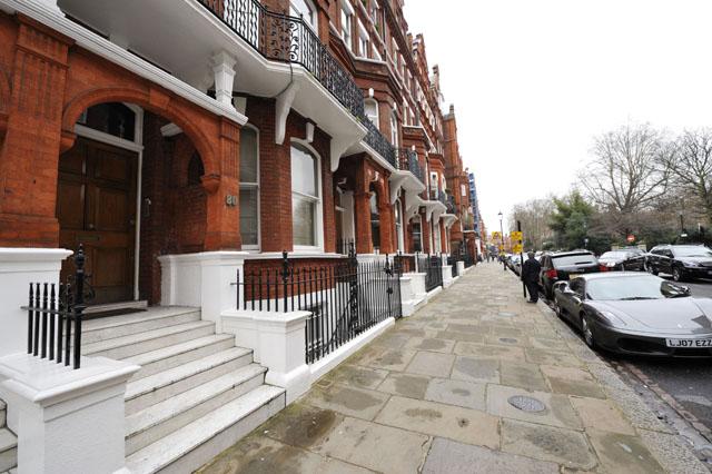
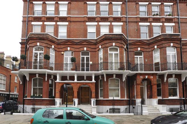
Photo 1 Photo 2
/ 2
Property details
Floor area
143 m²
Deprivation
Decile 8 (25,158 of 33,755)
Street crime
1115 incidents within 1 mile (Apr 2026)
Description
The property comprises: Large Reception : Fully Fitted Kitchen : 3 Bedrooms : 3 Bathrooms : Caretaker1 Large Reception : Fully Fitted Kitchen : 3 Bedrooms : 3 Bathrooms. Balcony overlooking Square.Cadogan Square is ideally situated for all the amenities offered by Sloane Street, Sloane Square and Knightsbridge.
Listed by
London
M2 Property
Reference: 31958378
EPC Rating & Upgrade Cost
Fetching EPC data… Refresh this page in a moment.
Flood risk
Zone: 1
Risk: Low
Job (default Low)
Floorplans
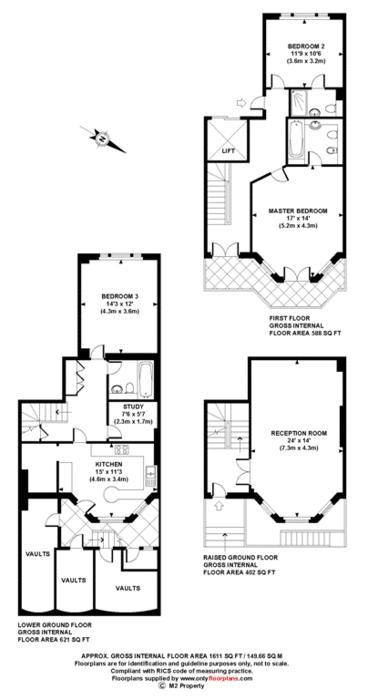
Floorplan 1
Company ownership
Registered legal owner is a company.
Company: 1 BISHOPS AVENUE LIMITED (11676713)
Rental Range
Estimated market rent for Kensington and Chelsea. Low = conservative, Realistic = average, Optimistic = best case.
Based on Local Authority from postcode lookup → Kensington and Chelsea.
LHA (30th percentile) floor for Central London: £2,154/mo (Apr 2025 – Mar 2026)
Location
Nearby
Nearest stations, universities and amenities (distance from property).
| Type | Name | Distance |
|---|---|---|
| Shop | Rosamosario | 0.1 miles |
| Shop | Papersmiths | 0.1 miles |
| Bus stop | Sloane Street / Sloane Square Station | 0.2 miles |
| Bus stop | Sloane Square Station / Symon Street | 0.2 miles |
| Train station | Sloane Square | 0.3 miles |
| Train station | South Kensington | 0.5 miles |
| University | National Heart and Lung Institute | 0.7 miles |
| Hospital | Bridge Lane Health Centre | 1.5 miles |
| University | University of Notre Dame | 1.6 miles |
| Hospital | Tunica Diagnostics | 1.9 miles |
Street-level crime
| Category | Count |
|---|---|
| Anti-social behaviour | 227 |
| Other theft | 178 |
| Violence and sexual offences | 175 |
| Theft from the person | 133 |
| Shoplifting | 122 |
| Vehicle crime | 87 |
| Public order | 53 |
| Criminal damage and arson | 33 |
| Burglary | 29 |
| Drugs | 28 |
| Robbery | 18 |
| Bicycle theft | 15 |
| Other crime | 12 |
| Possession of weapons | 5 |
| Total incidents | 1115 |
Within 1 mile during Apr 2026. Source: data.police.uk (England & Wales).
Schools nearby
Nearest open schools with Ofsted ratings (England). Closed schools are not shown. Data from Get Information about Schools and Ofsted.
| Name | Type | Distance | Ofsted |
|---|---|---|---|
| Sussex House School | Other | 0.0 miles | — (No rating) |
| St Joseph's Catholic Primary School | Primary | 0.1 miles | Outstanding — 12 Jun 2024 |
| St. Thomas More Language College | Secondary | 0.1 miles | Good — 21 Sep 2022 |
| Knightsbridge School | Other | 0.2 miles | — (No rating) |
| Hill House School | Other | 0.2 miles | Good — 4 Oct 2022 |
Rental Comparables
Residential lets from OpenRent and Rightmove for the area (same bedroom count). Use to validate rent estimates. Student lets are excluded.
| Title | Rent | Beds | Distance | As seen on |
|---|---|---|---|---|
| 3 Bed Penthouse, Beaufort Gardens, SW3 | £7,250/mo | 3 | 0.27 miles | OpenRent |
Average rent: £7,250/mo (1 listing)