53 HENLEY ROAD
LEICESTER, LEICESTER, LEICESTER LE3 9RD
£150,000
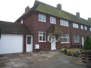

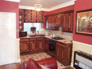
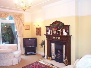
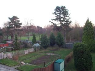
Photo 1 Photo 2 Photo 3 Photo 4 Photo 5
/ 5
Property details
Last sold
£150,000 Apr 2004
Local average
£189,233 (-20.7%)
Deprivation
Decile 3 (9,596 of 33,755)
Street crime
826 incidents within 1 mile (Apr 2026)
Key features
- sealed unit double glazing, GCH
- hall, lounge 22' oak fitted dining kitchen
- landing leading to three bedrooms
- victorian style bathroom, garage with utility area
- cloaks/wc, fabulous rear garden with southerly treed view
Description
Listed by
Leicester
Countrywide UK Sales - Connells
Reference: 2483921
EPC Rating & Upgrade Cost
Fetching EPC data… Refresh this page in a moment.
Flood risk
Zone: 2
Risk: In flood risk area
Environment Agency Flood Risk Areas (APSFR)
Price history
| Event | Date | Price | % change |
|---|---|---|---|
| Sold | 07/04/2004 (22 years ago) | £150,000 | — |
Source: HM Land Registry Price Paid Data. Crown copyright.
Sold Comparables
Same street and nearby sales within 0.25 miles (last 5 years). Data from Land Registry Price Paid.
| Address | Price | Date | Type |
|---|---|---|---|
| 42 POOL ROAD, LEICESTER, LE3 9GD | £180,000 | 16/01/2026 | Terraced |
| 52 HENTON ROAD, LEICESTER, LE3 6AX | £179,000 | 18/12/2025 | Terraced |
| 38 POOL ROAD, LEICESTER, LE3 9GD | £168,000 | 14/11/2025 | Terraced |
| 104 POOL ROAD, LEICESTER, LE3 9GE | £160,000 | 06/12/2023 | Terraced |
| 16 ST DUNSTAN ROAD, LEICESTER, LE3 9DD | £230,000 | 30/11/2023 | Terraced |
| 52 BOLTON ROAD, LEICESTER, LE3 6AB | £140,000 | 03/11/2023 | Terraced |
| 15 MERTON AVENUE, LEICESTER, LE3 6BF | £195,000 | 05/09/2023 | Terraced |
| 61 HENTON ROAD, LEICESTER, LE3 6AY | £215,000 | 28/07/2023 | Terraced |
| 35 MURIEL ROAD, LEICESTER, LE3 6BH | £100,000 | 20/07/2023 | Terraced |
| 39 HENTON ROAD, LEICESTER, LE3 6AY | £165,000 | 14/07/2023 | Terraced |
| 16 MERTON AVENUE, LEICESTER, LE3 6BF | £242,000 | 30/06/2023 | Terraced |
| 47 MOSTYN STREET, LEICESTER, LE3 6DU | £160,000 | 20/03/2023 | Terraced |
| 21 MURIEL ROAD, LEICESTER, LE3 6BH | £160,000 | 06/12/2022 | Terraced |
| 66 CARLISLE STREET, LEICESTER, LE3 6AG | £160,000 | 25/11/2022 | Terraced |
| 65 TETUAN ROAD, LEICESTER, LE3 9RT | £202,000 | 25/11/2022 | Terraced |
| 74 TYRRELL STREET, LEICESTER, LE3 5SA | £170,500 | 21/09/2022 | Terraced |
| 55 MURIEL ROAD, LEICESTER, LE3 6BH | £179,000 | 05/09/2022 | Terraced |
| 80 HENLEY ROAD, LEICESTER, LE3 9RB | £236,000 | 28/07/2022 | Terraced |
| 5 MURIEL ROAD, LEICESTER, LE3 6BH | £155,000 | 19/07/2022 | Terraced |
| 13 MURIEL ROAD, LEICESTER, LE3 6BH | £155,000 | 08/07/2022 | Terraced |
Area average: £177,575 (20 sales)
Capital growth trend
Land Registry outcode average: last 12 months vs 5y and 10y ago (from sold prices).
House Price Index (HM Land Registry — official index, not sold-price averages): Leicester. Series: Terraced. As of March 2026.
Rental Range
Estimated market rent for Leicester. Low = conservative, Realistic = average, Optimistic = best case.
Based on Local Authority from postcode lookup → Leicester.
LHA (30th percentile) floor for Leicester: £773/mo (Apr 2025 – Mar 2026)
Location
Nearby
Nearest stations, universities and amenities (distance from property).
| Type | Name | Distance |
|---|---|---|
| Bus stop | Henley Road | 0.1 miles |
| Shop | Family Shopper | 0.1 miles |
| Shop | Headmasters | 0.1 miles |
| Bus stop | Woodville Road | 0.1 miles |
| University | University of Leicester | 0.5 miles |
| University | De Montfort University | 0.9 miles |
| Train station | Unknown | 0.9 miles |
| Hospital | Leicester Royal Infirmary | 1.1 miles |
| Train station | Leicester | 1.4 miles |
| Hospital | South Entrance | 1.5 miles |
Street-level crime
| Category | Count |
|---|---|
| Violence and sexual offences | 278 |
| Anti-social behaviour | 108 |
| Public order | 90 |
| Criminal damage and arson | 86 |
| Shoplifting | 71 |
| Other theft | 58 |
| Vehicle crime | 29 |
| Burglary | 27 |
| Drugs | 27 |
| Other crime | 15 |
| Bicycle theft | 14 |
| Robbery | 12 |
| Theft from the person | 7 |
| Possession of weapons | 4 |
| Total incidents | 826 |
Within 1 mile during Apr 2026. Source: data.police.uk (England & Wales).
Schools nearby
Nearest open schools with Ofsted ratings (England). Closed schools are not shown. Data from Get Information about Schools and Ofsted.
| Name | Type | Distance | Ofsted |
|---|---|---|---|
| Christ the King Catholic Voluntary Academy | Primary | 0.3 miles | — (Inspected (no overall grade)) |
| Inglehurst Infant School | Primary | 0.3 miles | Inadequate — 17 Nov 2022 |
| Inglehurst Junior School | Primary | 0.3 miles | Good — 12 Dec 2023 |
| Castle Mead Academy | Secondary | 0.5 miles | Outstanding — 16 Nov 2023 |
| Dovelands Primary School | Primary | 0.5 miles | Good — 26 Oct 2016 |
Rental Comparables
Rental listings exist nearby, but none matched the 3-bedroom count for this property.
Rent-driven metrics
Based on Area rent estimate.
- Rent ratio — Monthly rent ÷ purchase price (1% rule). 1%+ = strong, 0.8–1% = okay, <0.8% = weak for cashflow.
- Max investor price — Rent ÷ 0.8%; the price at which rent would be 0.8% of price (Stoke-style target).
- Target investor price — Rent ÷ 1%; the price at which rent would be 1% of price (strong cashflow band).
- Gross yield — Annual rent as % of purchase price (no costs).