Second Avenue
Stafford, ST16 1PR
£185,000
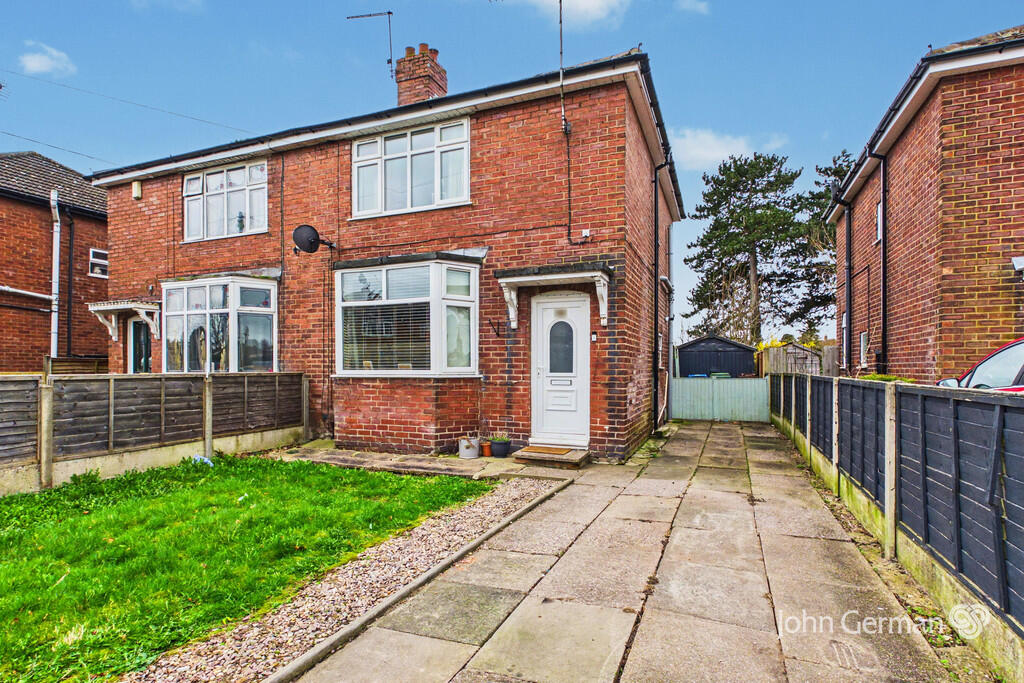

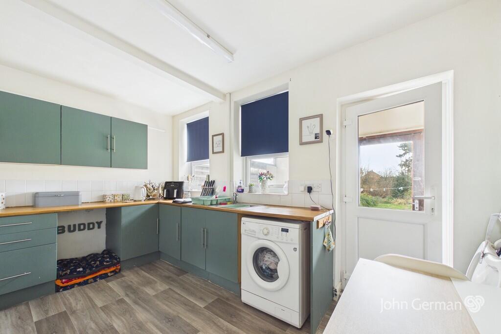
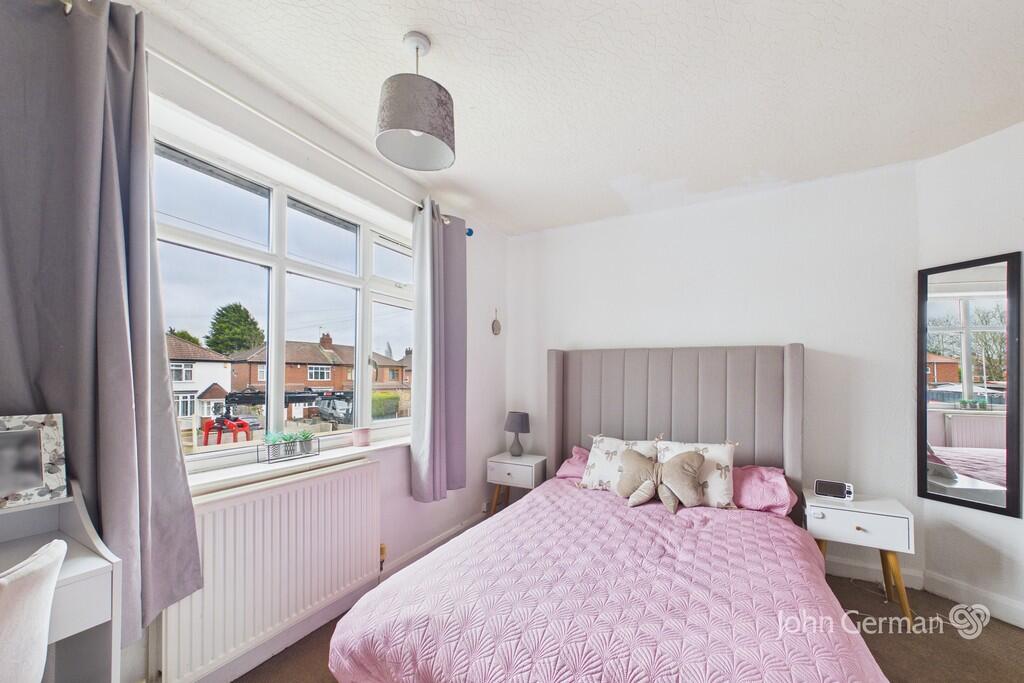

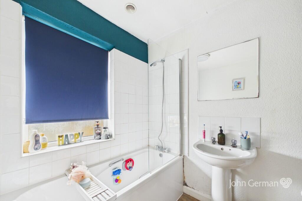
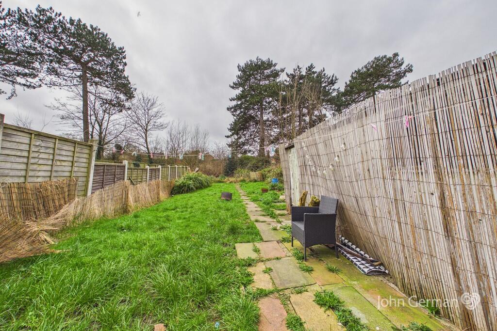
Photo 1 Photo 2 Photo 3 Photo 4 Photo 5 Photo 6 Photo 7
/ 7
Property details
Tenure
FREEHOLD
Council tax band
B
Local average
£215,497 (-14.2%)
Deprivation
Decile 8 (26,025 of 33,755)
Street crime
107 incidents within 1 mile (Mar 2026)
Key features
- Traditional semi-detached house
- Tastefully presented
- Pleasant lounge
- Attractive dining kitchen
- Ground floor WC & hall
- Off road parking
- Good size rear garden
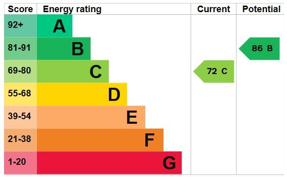
- EPC rating C. Council tax band B.
Additional details
- Electricity
- Mains supply
- Water
- Mains supply
- Sewerage
- Mains supply
- Heating
- Gas central
- Parking
- Off street
- Garden
- Yes
Description
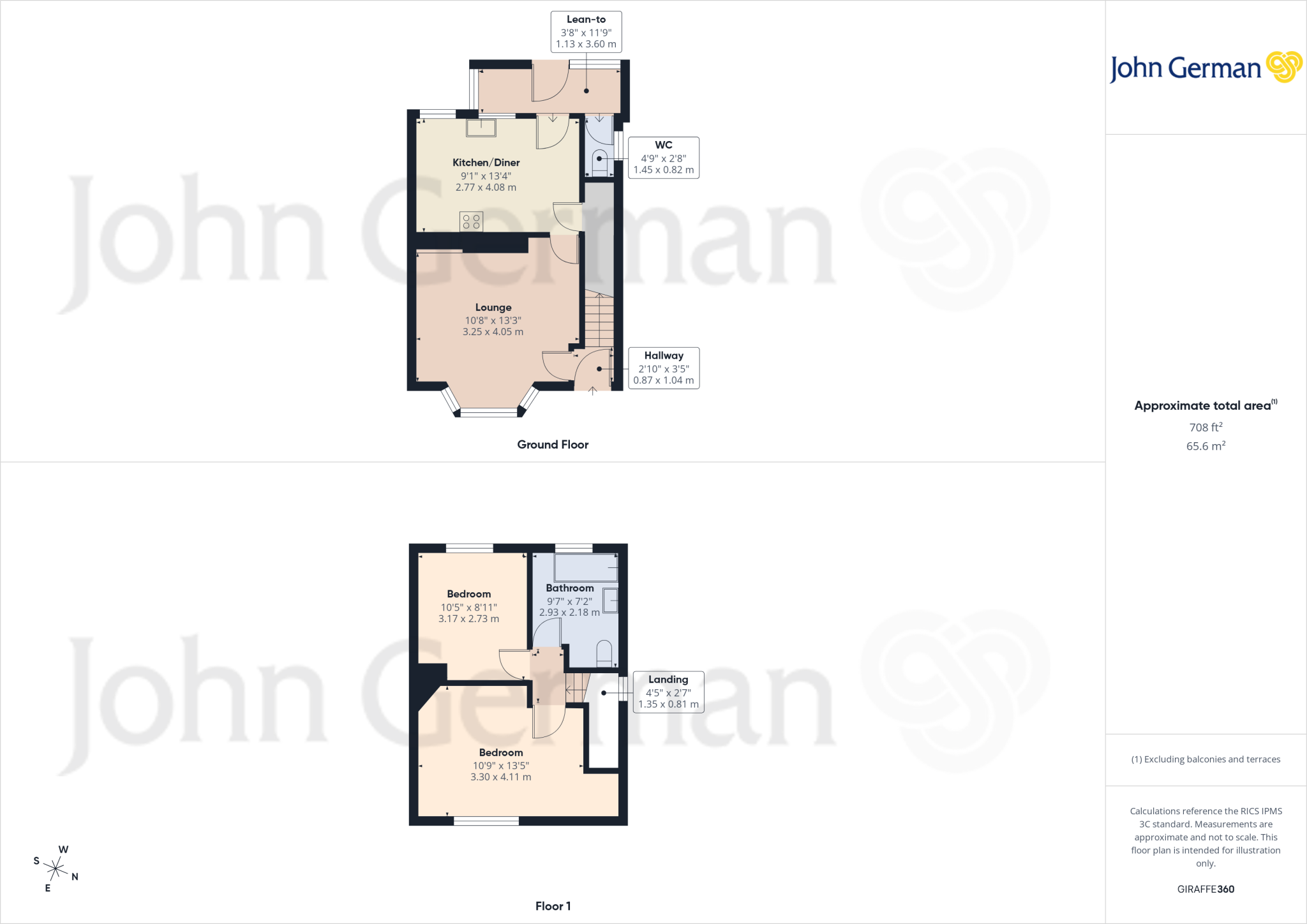
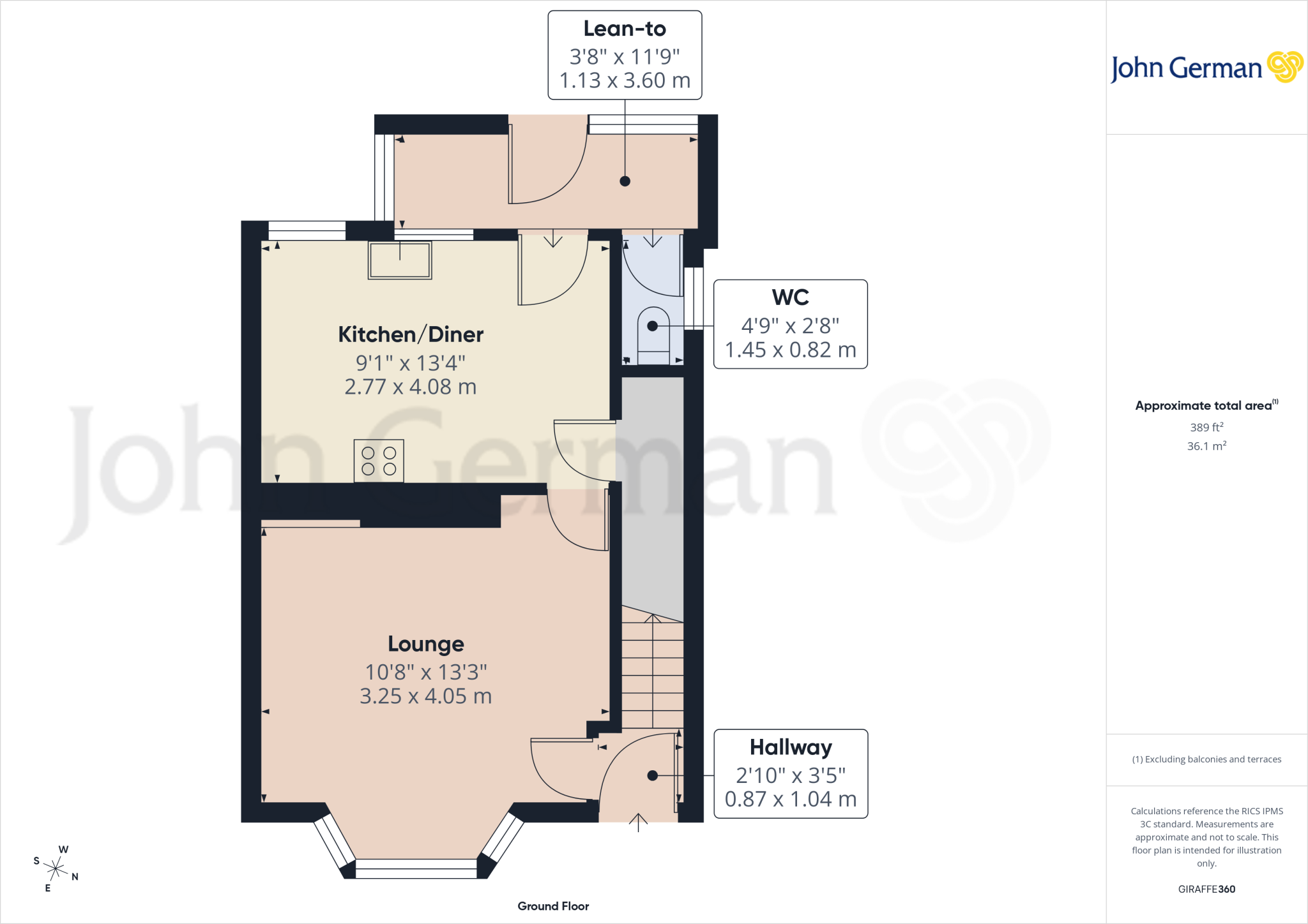
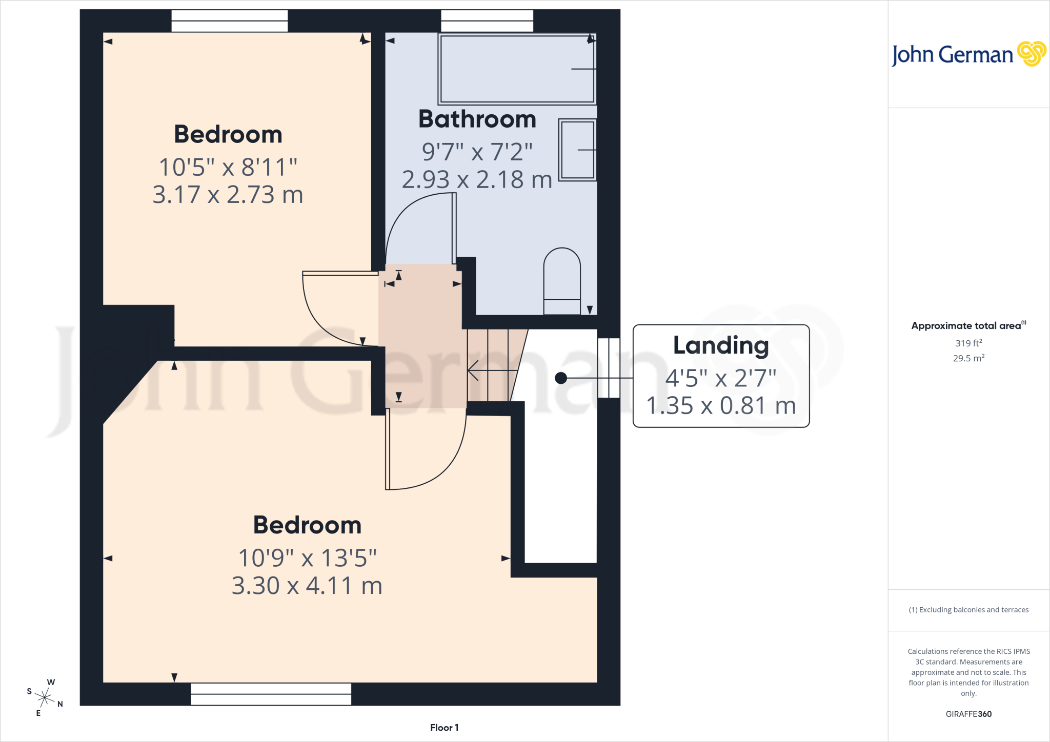
On the first floor, there are two double bedrooms and a family bathroom having a white suite comprising bath with shower and screen above, pedestal wash basin and WC.
Outside, the property stands back from the road beyond a lawn fore garden and parking space for at least one car. To the rear of the property lies a good size lawned rear garden.
The house is situated in a traditional, established location which is very popular, having local facilities and schools nearby. The county town centre of Stafford has a mainline intercity railway station with regular services to London Euston, some of which take only approximately 1 hour 20 minutes. Junction 14 of the M6 is a couple of minutes' drive away and provides direct access into the national motorway network and M6 toll.
To view this property, please contact John German Stafford office.
Agents notes: The property is currently tenanted.
The Land Registry document refers to covenants and a copy of which is available upon request.
Tenure: Freehold (purchasers are advised to satisfy themselves as to the tenure via their legal representative).
Please note: It is quite common for some properties to have a Ring doorbell and internal recording devices.
Property construction:
Parking:
Electricity supply:
Water supply:
Sewerage:
Heating:
(Purchasers are advised to satisfy themselves as to their suitability).
Broadband type: See Ofcom link for speed:
Mobile signal/coverage: See Ofcom link
Local Authority/Tax Band: Staffordshire County Council / Tax Band B
Useful Websites:
Our Ref: JGA/16032026
The property information provided by John German Estate Agents Ltd is based on enquiries made of the vendor and from information available in the public domain. If there is any point on which you require further clarification, please contact the office and we will be pleased to check the information for you, particularly if contemplating travelling some distance to view the property. Please note if your enquiry is of a legal or structural nature, we advise you to seek advice from a qualified professional in their relevant field.
We are required by law to comply fully with The Money Laundering Regulations 2017 and as such need to complete AML ID verification and proof / source of funds checks on all buyers and, where relevant, cash donors once an offer is accepted on a property. We use the Checkboard app to complete the necessary checks, this is not a credit check and therefore will have no effect on your credit history. With effect from 1st March 2025 a non-refundable compliance fee of £30.00 inc. VAT per buyer / donor will be required to be paid in advance when an offer is agreed and prior to a sales memorandum being issued.
Listed by
Stafford
John German
Reference: 173431727
EPC ratings on this postcode
We don't have a matched EPC for this property yet. Below are efficiency scores and details for other addresses on this postcode.
| Address | Current | Potential | Floor area | Age band | Type |
|---|---|---|---|---|---|
| 38, Second Avenue, STAFFORD | 56 | 79 | 112 m² | England and Wales: 1930-1949 | Detached |
| 44, Second Avenue, STAFFORD | 52 | 72 | 100 m² | — | Detached |
| 47 Second Avenue, STAFFORD | 65 | 83 | 67 m² | England and Wales: 1930-1949 | Detached |
| 48, Second Avenue, STAFFORD | 58 | 73 | 128 m² | — | Detached |
| 48, Second Avenue, STAFFORD | 56 | 71 | 129 m² | — | Detached |
| 49, Second Avenue, STAFFORD | 60 | 80 | 77 m² | England and Wales: 1930-1949 | Detached |
| 50, Second Avenue, STAFFORD | 68 | 83 | 85 m² | England and Wales: 1930-1949 | Detached |
| 50, Second Avenue, STAFFORD | 67 | 84 | 84 m² | England and Wales: 1930-1949 | Detached |
| 51, Second Avenue, STAFFORD | 73 | 87 | 75 m² | England and Wales: 1930-1949 | Detached |
| 52, Second Avenue, STAFFORD | 66 | 82 | 68 m² | England and Wales: 1930-1949 | Detached |
| 55, Second Avenue, STAFFORD | 68 | 84 | 67 m² | England and Wales: 1930-1949 | Detached |
| 58, Second Avenue, STAFFORD | 60 | 81 | 72 m² | England and Wales: 1930-1949 | Detached |
| 59, Second Avenue, STAFFORD | 68 | 85 | 79 m² | England and Wales: 1950-1966 | Detached |
| 59, Second Avenue, STAFFORD | 24 | 79 | 68 m² | England and Wales: 1950-1966 | Detached |
| 60, Second Avenue, STAFFORD | 49 | 73 | 77 m² | England and Wales: 1930-1949 | Detached |
Flood risk
Zone: 1
Risk: Low
Job (default Low)
Floorplans
Floorplan 1
Floorplan 2
Floorplan 3
EPC Graphs
EPC 1
Price history
| Event | Date | Price | % change |
|---|---|---|---|
| Listed for sale | — | £185,000 | — |
Source: HM Land Registry Price Paid Data. Crown copyright.
Sold Comparables
Same street and nearby sales within 0.25 miles (last 5 years). Data from Land Registry Price Paid.
| Address | Price | Date | Type |
|---|---|---|---|
| 35 CARDER AVENUE, STAFFORD, STAFFORDSHIRE, ST16 1QU | £230,000 | 18/12/2025 | Semi-detached |
| 75 FIRST AVENUE, STAFFORD, STAFFORDSHIRE, ST16 1QB | £210,000 | 21/11/2025 | Semi-detached |
| 348 ECCLESHALL ROAD, STAFFORD, STAFFORDSHIRE, ST16 1JN | £360,000 | 19/11/2025 | Semi-detached |
| 34 CHICORY END, STAFFORD, STAFFORDSHIRE, ST16 1QN | £214,696 | 19/09/2025 | Semi-detached |
| 262 STONE ROAD, STAFFORD, STAFFORDSHIRE, ST16 1NS | £220,000 | 09/07/2025 | Semi-detached |
| 17 BURCHAM CLOSE, STAFFORD, STAFFORDSHIRE, ST16 1RH | £175,000 | 07/03/2025 | Semi-detached |
| 33 HAWKE ROAD, STAFFORD, STAFFORDSHIRE, ST16 1PZ | £215,000 | 03/09/2024 | Semi-detached |
| 17 HOLMCROFT ROAD, STAFFORD, STAFFORDSHIRE, ST16 1JF | £170,000 | 31/10/2023 | Semi-detached |
| 46 WOODLANDS ROAD, STAFFORD, STAFFORDSHIRE, ST16 1QP | £230,000 | 27/10/2023 | Semi-detached |
| 22 BRAMALL LANE, STAFFORD, STAFFORDSHIRE, ST16 1JD | £264,000 | 27/10/2023 | Semi-detached |
| 12 SAYERS ROAD, STAFFORD, STAFFORDSHIRE, ST16 1QD | £175,000 | 12/10/2023 | Semi-detached |
| 23 HAWKE ROAD, STAFFORD, STAFFORDSHIRE, ST16 1PZ | £175,000 | 28/09/2023 | Semi-detached |
| 36 HURLINGHAM ROAD, STAFFORD, STAFFORDSHIRE, ST16 1QW | £208,500 | 25/09/2023 | Semi-detached |
| 40 GOUGH CLOSE, STAFFORD, STAFFORDSHIRE, ST16 1QF | £157,000 | 08/09/2023 | Semi-detached |
| 12 SAYERS ROAD, STAFFORD, STAFFORDSHIRE, ST16 1QD | £180,000 | 25/08/2023 | Semi-detached |
| 28 SAYERS ROAD, STAFFORD, STAFFORDSHIRE, ST16 1QD | £190,000 | 04/08/2023 | Semi-detached |
| 25 SECOND AVENUE, STAFFORD, STAFFORDSHIRE, ST16 1PP | £183,000 | 21/07/2023 | Semi-detached |
| 70 SECOND AVENUE, STAFFORD, STAFFORDSHIRE, ST16 1PS | £255,750 | 07/07/2023 | Semi-detached |
| 11 FIRST AVENUE, STAFFORD, STAFFORDSHIRE, ST16 1PT | £195,000 | 26/06/2023 | Semi-detached |
| 64 FIRST AVENUE, STAFFORD, STAFFORDSHIRE, ST16 1QB | £202,075 | 23/06/2023 | Semi-detached |
Area average: £210,501 (20 sales)
Capital growth trend
Land Registry outcode average: last 12 months vs 5y and 10y ago (from sold prices).
House Price Index (HM Land Registry — official index, not sold-price averages): Stafford. Series: Semi-detached. As of March 2026.
Rental Range
Estimated market rent for Stafford. Low = conservative, Realistic = average, Optimistic = best case.
Based on Local Authority from postcode lookup → Stafford.
LHA (30th percentile) floor for Mid Staffs: £623/mo (Apr 2025 – Mar 2026)
Location
Address
Second Avenue
Nearby
Nearest stations, universities and amenities (distance from property).
| Type | Name | Distance |
|---|---|---|
| Bus stop | Craddock Road | 0.0 miles |
| Bus stop | Hawke Road | 0.0 miles |
| Shop | Unknown | 0.2 miles |
| Shop | Coral | 0.2 miles |
| Hospital | St George's Hospital | 1.4 miles |
| Train station | Stafford | 1.5 miles |
| Hospital | County Hospital | 1.8 miles |
| University | Staffordshire University Blackheath Lane Site | 2.7 miles |
| Train station | Unknown | 4.9 miles |
Street-level crime
| Category | Count |
|---|---|
| Violence and sexual offences | 45 |
| Anti-social behaviour | 21 |
| Criminal damage and arson | 8 |
| Other theft | 8 |
| Public order | 6 |
| Shoplifting | 5 |
| Drugs | 4 |
| Burglary | 3 |
| Robbery | 3 |
| Other crime | 2 |
| Vehicle crime | 2 |
| Total incidents | 107 |
Within 1 mile during Mar 2026. Source: data.police.uk (England & Wales).
Schools nearby
Nearest open schools with Ofsted ratings (England). Closed schools are not shown. Data from Get Information about Schools and Ofsted.
| Name | Type | Distance | Ofsted |
|---|---|---|---|
| Greenhall | Other | 0.2 miles | Outstanding — 1 Feb 2013 |
| Marshlands School | Other | 0.2 miles | Good — 17 Dec 2014 |
| Tillington Manor Primary School | Primary | 0.2 miles | Requires improvement — 12 Jun 2023 |
| Sir Graham Balfour High School | Secondary | 0.5 miles | Good — 6 Jun 2014 |
| Parkside Primary School | Primary | 0.5 miles | Good — 27 Sep 2022 |
Rental Comparables
Loading rental comparables for this postcode. Refresh in a few minutes.
Rent-driven metrics
Based on Area rent estimate.
- Rent ratio — Monthly rent ÷ purchase price (1% rule). 1%+ = strong, 0.8–1% = okay, <0.8% = weak for cashflow.
- Max investor price — Rent ÷ 0.8%; the price at which rent would be 0.8% of price (Stoke-style target).
- Target investor price — Rent ÷ 1%; the price at which rent would be 1% of price (strong cashflow band).
- Gross yield — Annual rent as % of purchase price (no costs).
Enter House Number
Enter the house number to help us retrieve more accurate pricing history and property data.
Please log in to submit or correct the house number for this listing.
Log in to continue