Main Street
Red Row, NE61 5AG
£139,950

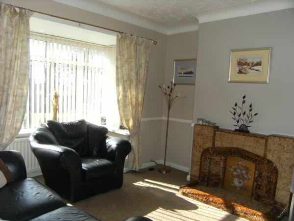


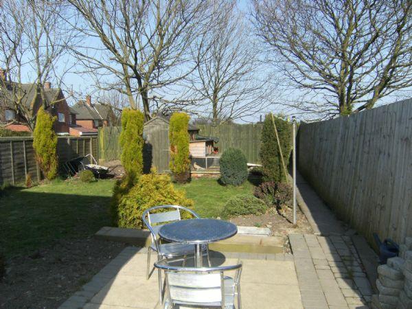
Photo 1 Photo 2 Photo 3 Photo 4 Photo 5 Photo 6 Photo 7 Photo 8
/ 8
Property details
Last sold
£25,000
Local average
£202,045 (-30.7%)
Deprivation
Decile 6 (17,155 of 33,755)
Street crime
28 incidents within 1 mile (Apr 2026)
Additional details
- Parking
- Yes
- Garden
- Yes
Description
Listed by
Amble
Rook Matthews Sayer - Connells
Reference: 15414789
EPC ratings on this postcode
We don't have a matched EPC for this property yet. Below are efficiency scores and details for other addresses on this postcode.
| Address | Current | Potential | Floor area | Age band | Type |
|---|---|---|---|---|---|
| 1 Chevington Mews, Main Street, Red Row, MORPETH | 67 | 84 | 87 m² | England and Wales: 1991-1995 | Detached |
| 3 Chevington Mews, Main Street, Red Row, MORPETH | 68 | 87 | 89 m² | England and Wales: 1983-1990 | Detached |
| 4 Chevington Mews, Main Street, Red Row, MORPETH | 68 | 84 | 87 m² | England and Wales: 1983-1990 | Detached |
| Aysgarth, Main Street, Red Row, MORPETH | 54 | 73 | 59 m² | England and Wales: 1930-1949 | Flat |
| Bardsea, Main Street, Red Row, MORPETH | 60 | 74 | 100 m² | England and Wales: 1950-1966 | Detached |
| Bay View, Main Street, Red Row, MORPETH | 54 | 73 | 65 m² | England and Wales: 1930-1949 | Flat |
| Ford Villa, Main Street, Red Row, MORPETH | 69 | 84 | 107 m² | England and Wales: 1950-1966 | Detached |
| Ford Villa, Main Street, Red Row, MORPETH | 51 | 83 | 100 m² | England and Wales: 1930-1949 | Detached |
| Garview, Main Street, Red Row, MORPETH | 51 | 78 | 130 m² | England and Wales: 1967-1975 | Detached |
| Roosebeck, Main Street, Red Row, MORPETH | 60 | 76 | 65 m² | England and Wales: 1950-1966 | Detached |
| Walney, Main Street, Red Row, MORPETH | 49 | 82 | 69 m² | England and Wales: 1930-1949 | Detached |
| Wensley House, Main Street, Red Row, MORPETH | 62 | 70 | 60 m² | England and Wales: 1930-1949 | Flat |
| Wheatfield House, Main Street, Red Row, MORPETH | 42 | 83 | 107 m² | England and Wales: 1900-1929 | Detached |
| Wheatfield House, Main Street, Red Row, MORPETH | 61 | 88 | 96 m² | England and Wales: 1930-1949 | Detached |
| Willow House, Main Street, Red Row, MORPETH | 43 | 78 | 103 m² | England and Wales: 1950-1966 | Detached |
Flood risk
Zone: 1
Risk: Low
Job (default Low)
Price history
No sales history found for this property in Land Registry Price Paid data.
Sold Comparables
Same street and nearby sales within 0.25 miles (last 5 years). Data from Land Registry Price Paid.
| Address | Price | Date | Type |
|---|---|---|---|
| ASHLEIGH MAIN STREET, RED ROW, MORPETH, NORTHUMBERLAND, NE61 5AJ | £185,000 | 23/06/2023 | Semi-detached |
| GREY ARMS COURT 2 MAIN STREET, RED ROW, MORPETH, NORTHUMBERLAND, NE61 5BF | £190,000 | 28/01/2022 | Semi-detached |
| KIA ORA MAIN STREET, RED ROW, MORPETH, NORTHUMBERLAND, NE61 5AQ | £180,000 | 19/11/2021 | Semi-detached |
Area average: £185,000 (3 sales)
Capital growth trend
Land Registry outcode average: last 12 months vs 5y and 10y ago (from sold prices).
House Price Index (HM Land Registry — official index, not sold-price averages): Northumberland. Series: Semi-detached. As of March 2026.
Rental Range
Estimated market rent for Northumberland. Low = conservative, Realistic = average, Optimistic = best case.
Based on Local Authority from postcode lookup → Northumberland.
LHA (30th percentile) floor for Northumberland: £529/mo (Apr 2025 – Mar 2026)
Location
Nearby
Nearest stations, universities and amenities (distance from property).
| Type | Name | Distance |
|---|---|---|
| Bus stop | Unknown | 0.1 miles |
| Bus stop | Smally's Bar | 0.1 miles |
| Shop | The Co-operative Food | 0.4 miles |
| Shop | Hadston Newsagency | 0.4 miles |
| Train station | Acklington | 2.2 miles |
| Train station | Widdrington | 3.3 miles |
| Hospital | St George's Hospital | 8.2 miles |
| Hospital | Northgate Hospital | 8.2 miles |
Street-level crime
| Category | Count |
|---|---|
| Violence and sexual offences | 6 |
| Anti-social behaviour | 4 |
| Burglary | 4 |
| Criminal damage and arson | 4 |
| Other crime | 2 |
| Public order | 2 |
| Shoplifting | 2 |
| Vehicle crime | 2 |
| Other theft | 1 |
| Theft from the person | 1 |
| Total incidents | 28 |
Within 1 mile during Apr 2026. Source: data.police.uk (England & Wales).
Schools nearby
Nearest open schools with Ofsted ratings (England). Closed schools are not shown. Data from Get Information about Schools and Ofsted.
| Name | Type | Distance | Ofsted |
|---|---|---|---|
| Red Row Primary School | Primary | 0.3 miles | Good — 4 Mar 2013 |
| Broomhill Primary School | Primary | 1.2 miles | Good — 1 Nov 2011 |
| James Calvert Spence College | Secondary | 2.7 miles | Good — 21 Sep 2022 |
| King Edwin Primary School | Primary | 2.9 miles | Good — 14 Nov 2019 |
| Amble Links Primary School | Primary | 3.3 miles | — (Inspected (no overall grade)) |
Rental Comparables
Residential lets from OpenRent and Rightmove for the area (same bedroom count). Use to validate rent estimates. Student lets are excluded.
| Title | Rent | Beds | Distance | As seen on |
|---|---|---|---|---|
| 3 Bed Semi-Detached House, Beachcroft, NE65 | £925/mo | 3 | 0.5 miles | OpenRent |
Average rent: £925/mo (1 listing)
Rent-driven metrics
Based on OpenRent comparables.
- Rent ratio — Monthly rent ÷ purchase price (1% rule). 1%+ = strong, 0.8–1% = okay, <0.8% = weak for cashflow.
- Max investor price — Rent ÷ 0.8%; the price at which rent would be 0.8% of price (Stoke-style target).
- Target investor price — Rent ÷ 1%; the price at which rent would be 1% of price (strong cashflow band).
- Gross yield — Annual rent as % of purchase price (no costs).
- Cost-to-rent — Price ÷ annual rent (from OpenRent comparables). Under 14× = strong, 14–16× = acceptable, 17×+ = compressed.
- Cashflow — Rent minus mortgage, 10% maintenance, £25/mo compliance. Assumes 75% LTV, 3.95% APR (5yr fixed), 25yr term.
- ROI — Annual profit ÷ cash in (deposit + 4% purchase costs).
Enter House Number
Enter the house number to help us retrieve more accurate pricing history and property data.
Please log in to submit or correct the house number for this listing.
Log in to continue