Charlesworth Terrace
Pellon, Halifax, HX2 0EW
£90,000
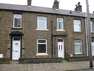
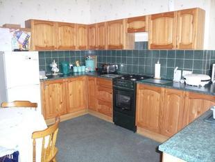
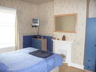
Photo 1 Photo 2 Photo 3
/ 3
Property details
Last sold
£120,000
Local average
£284,000 (-68.3%)
Deprivation
Decile 1 (3,279 of 33,755)
Street crime
463 incidents within 1 mile (Apr 2026)
Key features
- Stone Through Terrace
- Two Bedrooms
- Lounge & Dining Kitchen
- Gas Central Heating
- Double Glazing
- Rear Yard Area
- No Vendor Chain
Description
A two bedroom, stone through terrace house situated in this popular residential location. Gas central heating, double glazing, popular with first time buyers. Comprises of an entrance hall, lounge, dining kitchen, cellar/utility. First floor two bedrooms, bathroom. Apply Halifax.
DESCRIPTION
A two bedroom, stone through terrace house situated in this popular residential location. Gas central heating, double glazing, popular with first time buyers. Comprises of an entrance hall, lounge, dining kitchen, cellar/utility. First floor two bedrooms, bathroom. Apply Halifax.
Entrance Hall
With radiator, double glazed entrance door and staircase to first floor.
Lounge 12' x 11' 4" ( 3.66m x 3.45m )
Pleasant living room to the front with double glazed window, radiator and gas fire.
Dining Kitchen 13' x 10' 6" ( 3.96m x 3.20m )
Having a modern range of wall and base units with complimenting worktop surfaces, radiator, double glazed window and rear door.
Cellar
Currently used as a utility room.
First Floor Landing
With radiator and built in cupboard.
Bedroom 1 13' x 9' ( 3.96m x 2.74m )
Bedroom to the rear with double glazed window, radiator and cast iron fireplace.
Bedroom 2 12' x 10' 4" ( 3.66m x 3.15m )
Bedroom to the front with double glazed window.
Bathroom
Three piece suite comprising W.C., wash hand basin, rectangular bath, radiator and double glazed window.
Outside
Frontage area and rear yard area.
DIRECTIONS
Proceed up Pellon Lane towards Moorend Road. Turn left into Springhall Lane the first right into Long Lover Lane. Right into Charlesworth Terrace.
Listed by
Halifax
Sequence (UK) Limited - Connells
Reference: 15381802
EPC ratings on this postcode
We don't have a matched EPC for this property yet. Below are efficiency scores and details for other addresses on this postcode.
| Address | Current | Potential | Floor area | Age band | Type |
|---|---|---|---|---|---|
| 1, Charlesworth Terrace, HALIFAX | 60 | 83 | 58 m² | England and Wales: 1930-1949 | Terraced |
| 10, Charlesworth Terrace, HALIFAX | 54 | 81 | 70 m² | England and Wales: before 1900 | Terraced |
| 11, Charlesworth Terrace, HALIFAX | 62 | 84 | 59 m² | England and Wales: 1900-1929 | Terraced |
| 11, Charlesworth Terrace, HALIFAX | 49 | 85 | 64 m² | England and Wales: 1930-1949 | Detached |
| 12, Charlesworth Terrace, HALIFAX | 29 | 79 | 130 m² | England and Wales: 1900-1929 | Terraced |
| 12, Charlesworth Terrace, HALIFAX | 28 | 79 | 145 m² | England and Wales: 1900-1929 | Terraced |
| 12, Charlesworth Terrace, HALIFAX | 31 | 78 | 122 m² | England and Wales: before 1900 | Terraced |
| 13, Charlesworth Terrace, HALIFAX | 61 | 86 | 59 m² | England and Wales: 1930-1949 | Terraced |
| 15, Charlesworth Terrace, HALIFAX | 64 | 84 | 59 m² | England and Wales: 1900-1929 | Terraced |
| 17, Charlesworth Terrace, HALIFAX | 41 | 75 | 99 m² | England and Wales: before 1900 | Terraced |
| 18, Charlesworth Terrace, HALIFAX | 51 | 80 | 65 m² | England and Wales: before 1900 | Terraced |
| 19 Charlesworth Terrace, HALIFAX | 69 | 90 | 55 m² | England and Wales: 1900-1929 | Terraced |
| 19, Charlesworth Terrace, HALIFAX | 69 | 90 | 61 m² | England and Wales: before 1900 | Terraced |
| 19, Charlesworth Terrace, HALIFAX | 37 | 74 | 58 m² | England and Wales: 1930-1949 | Terraced |
| 2, Charlesworth Terrace, HALIFAX | 51 | 78 | 128 m² | England and Wales: before 1900 | Terraced |
Flood risk
Zone: 1
Risk: Low
Job (default Low)
Price history
35% since 2007
| Event | Date | Price | % change |
|---|---|---|---|
| Sold | 01/01/2023 (3 years ago) | £120,000 | +34.8% |
| Sold | 01/01/2007 (19 years ago) | £89,000 | — |
Source: HM Land Registry Price Paid Data. Crown copyright.
Sold Comparables
Same street and nearby sales within 0.25 miles (last 5 years). Data from Land Registry Price Paid.
| Address | Price | Date | Type |
|---|---|---|---|
| THE OLD VICARAGE CHURCH LANE, HALIFAX, CALDERDALE, WEST YORKSHIRE, HX2 0EF | £505,000 | 23/01/2025 | Other |
| Same street 44 CHARLESWORTH TERRACE, HALIFAX, CALDERDALE, WEST YORKSHIRE, HX2 0EW | £120,000 | 24/11/2023 | Terraced |
| Same street 13 CHARLESWORTH TERRACE, HALIFAX, CALDERDALE, WEST YORKSHIRE, HX2 0EW | £120,000 | 17/07/2023 | Terraced |
| Same street 8 CHARLESWORTH TERRACE, HALIFAX, CALDERDALE, WEST YORKSHIRE, HX2 0EW | £70,000 | 07/10/2022 | Terraced |
| WHINHILL HOUSE CHURCH LANE, HALIFAX, CALDERDALE, WEST YORKSHIRE, HX2 0EF | £210,000 | 14/12/2021 | Other |
| Same street 17 CHARLESWORTH TERRACE, HALIFAX, CALDERDALE, WEST YORKSHIRE, HX2 0EW | £95,000 | 05/11/2021 | Terraced |
Street average: £101,250 (4 sales)
Area average: £357,500 (2 sales)
Capital growth trend
Land Registry outcode average: last 12 months vs 5y and 10y ago (from sold prices).
House Price Index (HM Land Registry — official index, not sold-price averages): Calderdale. Series: All dwelling types. As of March 2026.
Rental Range
Estimated market rent for Calderdale. Low = conservative, Realistic = average, Optimistic = best case.
Based on Local Authority from postcode lookup → Calderdale.
LHA (30th percentile) floor for Halifax: £524/mo (Apr 2025 – Mar 2026)
Location
Address
Charlesworth Terrace
Nearby
Nearest stations, universities and amenities (distance from property).
| Type | Name | Distance |
|---|---|---|
| Bus stop | Pellon New Road Stretchgate Lane | 0.1 miles |
| Shop | Morrisons Daily | 0.3 miles |
| Shop | Asda | 0.3 miles |
| Train station | Halifax | 1.6 miles |
| Train station | Sowerby Bridge | 1.6 miles |
| Hospital | Calderdale Royal Hospital | 2.1 miles |
| Hospital | Spire Elland Hospital | 3.7 miles |
| University | University of Bradford Oxenhope Field Site | 5.8 miles |
| University | University of Bradford | 6.6 miles |
Street-level crime
| Category | Count |
|---|---|
| Violence and sexual offences | 203 |
| Shoplifting | 49 |
| Public order | 44 |
| Criminal damage and arson | 39 |
| Anti-social behaviour | 37 |
| Other theft | 21 |
| Vehicle crime | 19 |
| Drugs | 16 |
| Burglary | 14 |
| Other crime | 13 |
| Robbery | 5 |
| Bicycle theft | 1 |
| Possession of weapons | 1 |
| Theft from the person | 1 |
| Total incidents | 463 |
Within 1 mile during Apr 2026. Source: data.police.uk (England & Wales).
Schools nearby
Nearest open schools with Ofsted ratings (England). Closed schools are not shown. Data from Get Information about Schools and Ofsted.
| Name | Type | Distance | Ofsted |
|---|---|---|---|
| Mount Pellon Primary Academy | Primary | 0.2 miles | Good — 10 Feb 2019 |
| Christ Church Pellon CofE VC Primary School | Primary | 0.3 miles | Good — 5 Jul 2017 |
| Ling Bob Junior, Infant and Nursery School | Primary | 0.4 miles | Good — 5 Dec 2017 |
| The Halifax Academy | Other | 0.4 miles | Good — 1 Aug 2023 |
| St Augustine's CofE School | Primary | 0.5 miles | Inadequate — 25 Nov 2021 |
Rental Comparables
Rental listings exist nearby, but none matched the 2-bedroom count for this property.
Rent-driven metrics
Based on Area rent estimate.
- Rent ratio — Monthly rent ÷ purchase price (1% rule). 1%+ = strong, 0.8–1% = okay, <0.8% = weak for cashflow.
- Max investor price — Rent ÷ 0.8%; the price at which rent would be 0.8% of price (Stoke-style target).
- Target investor price — Rent ÷ 1%; the price at which rent would be 1% of price (strong cashflow band).
- Gross yield — Annual rent as % of purchase price (no costs).
Enter House Number
Enter the house number to help us retrieve more accurate pricing history and property data.
Please log in to submit or correct the house number for this listing.
Log in to continue