80 OXFORD GARDENS
LONDON, GREATER LONDON W10 5UW
£370 pcm
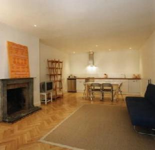
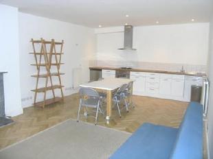
Photo 1 Photo 2
/ 2
Property details
Deprivation
Decile 4 (11,108 of 33,755)
Street crime
1565 incidents within 1 mile (Apr 2026)
Description
THE PROPERTY MISDESCRIPTIONS ACT 1991
The Agent has not tested any apparatus, equipment, fixtures and fittings or services and so cannot verify that they are in working order or fit for the purpose. A Buyer is advised to obtain verification from their Solicitor or Surveyor. References to the Tenure of a Property are based on information supplied by the Seller. The Agent has not had sight of the title documents. A Buyer is advised to obtain verification from their Solicitor. Items shown in photographs are NOT included unless specifically mentioned within the sales particulars. They may however be available by separate negotiation. Buyers must check the availability of any property and make an appointment to view before embarking on any journey to see a property.
Listed by
London
Ashdown Miles
Reference: 5649947
EPC Rating & Upgrade Cost
Fetching EPC data… Refresh this page in a moment.
Flood risk
Zone: 1
Risk: Low
Job (default Low)
Rental Range
Estimated market rent for Kensington and Chelsea. Low = conservative, Realistic = average, Optimistic = best case.
Based on Local Authority from postcode lookup → Kensington and Chelsea.
LHA (30th percentile) floor for Stevenage & North Herts: £773/mo (Apr 2025 – Mar 2026)
Location
Nearby
Nearest stations, universities and amenities (distance from property).
| Type | Name | Distance |
|---|---|---|
| Bus stop | Oxford Gardens | 0.0 miles |
| Shop | Nu-Line | 0.1 miles |
| Shop | Kensington Autocare Ltd | 0.1 miles |
| Train station | Ladbroke Grove | 0.2 miles |
| Train station | Latimer Road | 0.4 miles |
| University | Scale Space White City | 0.4 miles |
| University | Kennet West Skills Centre | 0.7 miles |
| Hospital | The Portland Hospital | 3.1 miles |
| Hospital | Sleep & Health Clinic | 3.2 miles |
Street-level crime
| Category | Count |
|---|---|
| Anti-social behaviour | 343 |
| Violence and sexual offences | 330 |
| Shoplifting | 310 |
| Other theft | 110 |
| Public order | 104 |
| Vehicle crime | 81 |
| Drugs | 57 |
| Theft from the person | 56 |
| Burglary | 54 |
| Criminal damage and arson | 53 |
| Robbery | 25 |
| Bicycle theft | 23 |
| Other crime | 10 |
| Possession of weapons | 9 |
| Total incidents | 1565 |
Within 1 mile during Apr 2026. Source: data.police.uk (England & Wales).
Schools nearby
Nearest open schools with Ofsted ratings (England). Closed schools are not shown. Data from Get Information about Schools and Ofsted.
| Name | Type | Distance | Ofsted |
|---|---|---|---|
| Bassett House School | Other | 0.1 miles | — (No rating) |
| All Saints Catholic College | Secondary | 0.1 miles | Outstanding — 28 Nov 2022 |
| La Petite Ecole Francaise | Other | 0.2 miles | Outstanding — 23 Apr 2018 |
| The Lloyd Williamson School Foundation | Other | 0.2 miles | Good — 28 Sep 2022 |
| Oxford Gardens Primary School | Primary | 0.2 miles | Good — 8 May 2023 |
Rental Comparables
Residential lets from OpenRent and Rightmove for the area (same bedroom count). Use to validate rent estimates. Student lets are excluded.
| Title | Rent | Beds | Distance | As seen on |
|---|---|---|---|---|
| 1 Bed Flat, Garden, W10 | £3,000/mo | 1 | 0.17 miles | OpenRent |
| 1 Bed Flat, St Lawrence Terrace, W10 | £1,950/mo | 1 | 0.24 miles | OpenRent |
Average rent: £2,475/mo (2 listings)