118 EDGWAREBURY LANE
EDGWARE, GREATER LONDON HA8 8NB
£2,300 pcm
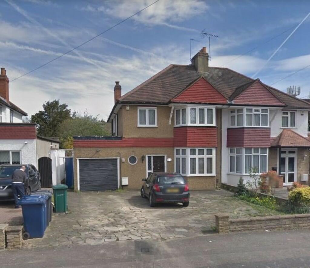
Photo 1
/ 1
Property details
Floor area
146 m²
EPC rating
D
Year built
England and Wales: 1930-1949
Deprivation
Decile 6 (19,783 of 33,755)
Street crime
264 incidents within 1 mile (Mar 2026)
Key features
- 4 BEDROOMS
- 3 RECEPTION ROOMS
- RECENTLY REDECORATED
- OFF STREET PARKING
- LARGE REAR GARDEN
- AVAILABLE IMMEDIATELY
- UNFURNISHED
- NO TENANT FEES
Additional details
- Parking
- Off street
- Garden
- Yes
Description
Listed by
Edgware
Taylor Hawkins Estate Agents
Reference: 134725415
EPC Rating & Upgrade Cost
Current rating: D
Potential rating: C
Inspection date: 07/09/2020
Current heating cost: £1,171/year
Potential heating cost: £961/year
Est. upgrade cost to C: £10,500
Recommendations
- Cavity wall insulation (£500 - £1,500)
- Floor insulation (solid floor) (£4,000 - £6,000)
- Solar photovoltaic panels, 2.5 kWp (£3,500 - £5,500)
Flood risk
Zone: 1
Risk: Low
Job (default Low)
Rental Range
Estimated market rent for Barnet. Low = conservative, Realistic = average, Optimistic = best case.
Based on Local Authority from postcode lookup → Barnet.
LHA (30th percentile) floor for South West Herts: £1,995/mo (Apr 2025 – Mar 2026)
Location
Nearby
Nearest stations, universities and amenities (distance from property).
| Type | Name | Distance |
|---|---|---|
| Bus stop | Parkside Drive | 0.1 miles |
| Shop | Stopps4tiles | 0.1 miles |
| Shop | Larry's Drycleaners | 0.1 miles |
| Bus stop | Edgwarebury Lane / Edgware Way | 0.1 miles |
| Train station | Edgware | 0.6 miles |
| Train station | Stanmore | 1.1 miles |
| University | Middlesex University | 2.4 miles |
| University | Flood Hazard Research Centre | 2.4 miles |
| Hospital | Watford General Hospital | 5.7 miles |
| Hospital | Priory Hospital | 6.9 miles |
Street-level crime
| Category | Count |
|---|---|
| Anti-social behaviour | 63 |
| Violence and sexual offences | 63 |
| Burglary | 19 |
| Other theft | 19 |
| Criminal damage and arson | 17 |
| Drugs | 16 |
| Public order | 16 |
| Shoplifting | 16 |
| Vehicle crime | 15 |
| Theft from the person | 8 |
| Robbery | 7 |
| Other crime | 3 |
| Possession of weapons | 2 |
| Total incidents | 264 |
Within 1 mile during Mar 2026. Source: data.police.uk (England & Wales).
Schools nearby
Nearest open schools with Ofsted ratings (England). Closed schools are not shown. Data from Get Information about Schools and Ofsted.
| Name | Type | Distance | Ofsted |
|---|---|---|---|
| Tashbar of Edgware | Other | 0.0 miles | Requires improvement — 18 Jan 2023 |
| Holland House School | Other | 0.2 miles | — (No rating) |
| Beit Shvidler Primary School | Primary | 0.4 miles | Good — 14 Apr 2019 |
| Edgware Jewish Girls - Beis Chinuch | Other | 0.4 miles | Good — 11 Sep 2024 |
| London Academy | Other | 0.5 miles | Good — 23 Nov 2023 |
Rental Comparables
Residential lets from OpenRent and Rightmove for the area (same bedroom count). Use to validate rent estimates. Student lets are excluded.
| Title | Rent | Beds | Distance | As seen on |
|---|---|---|---|---|
| 4 Bed Semi-Detached House, Warwick Avenue, HA8 | £3,500/mo | 4 | 0.43 miles | OpenRent |
| 4 Bed Semi-Detached House, Farm Road, HA8 | £3,250/mo | 4 | 0.62 miles | OpenRent |
Average rent: £3,375/mo (2 listings)