20 CLEARWATER CLOSE
LIVERPOOL, LIVERPOOL, MERSEYSIDE L7 2SA
£134,950
Property details
Floor area
89 m²
Last sold
£107,000 Dec 2008
Local average
£198,750 (-32.1%)
Deprivation
Decile 2 (3,940 of 33,755)
Street crime
622 incidents within 1 mile (Apr 2026)
Description
Three Bedrooms
Double Glazing and Gas Central Heating System
Gardens
No Chain
Room Descriptions
Location
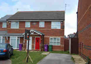
A three bedroom semi detached property situated on a small residential development within a cul-de-sac location. The property benefits from a gas central heating system double glazing and is offered for sale without chain. Internal viewing is recommended to appreciate the accommodation on offer. Clearwater Close can be accessed via Prescot Road Kensington.
Entrance Hall
1.83m � 1.17m (6'0'' � 3'10'')
Single radiator. Stairs to the first floor. Laminate flooring.
Lounge
4.95m � 3.76m (16'3'' � 12'4'')
Television point. Single radiator. Laminate flooring. Under stairs storage cupboard. Double doors through to:-
Kitchen/Diner
4.72m � 2.87m (15'6'' � 9'5'')
Fitted base and wall units. Stainless steel single drainer sink unit. Plumbing for automatic washing machine. Part tiled walls. Ceramic tiled flooring. Single radiator.
First Floor Landing
Laminate flooring
Bedroom One
4.50m � 2.64m (14'9'' � 8'8" )
Single radiator. Laminate flooring.
Bedroom Two
3.51m � 2.31m (11'6'' � 7'7'')
Single radiator. Laminate flooring.
Bedroom Three
2.44m � 2.39m (8'0'' � 7'10'')
Single radiator. Laminate flooring.
Outside
Front garden and driveway. Rear garden with lawn and timber panelled fencing.
Listed by
Old Swan
Farrell Heyworth
Reference: 16188412
EPC Rating & Upgrade Cost
Fetching EPC data… Refresh this page in a moment.
Flood risk
Zone: 1
Risk: Low
Job (default Low)
Price history
| Event | Date | Price | % change |
|---|---|---|---|
| Sold | 19/12/2008 (17 years ago) | £107,000 | — |
Source: HM Land Registry Price Paid Data. Crown copyright.
Sold Comparables
Same street and nearby sales within 0.25 miles (last 5 years). Data from Land Registry Price Paid.
| Address | Price | Date | Type |
|---|---|---|---|
| 18 JOHN LENNON DRIVE, LIVERPOOL, MERSEYSIDE, L6 9HT | £230,000 | 25/11/2022 | Semi-detached |
| 6 JOHN LENNON DRIVE, LIVERPOOL, MERSEYSIDE, L6 9HT | £170,000 | 25/11/2022 | Semi-detached |
| 18 FARNWORTH STREET, LIVERPOOL, MERSEYSIDE, L6 9BB | £210,000 | 31/10/2022 | Semi-detached |
| 29 INGROW ROAD, LIVERPOOL, MERSEYSIDE, L6 9AJ | £162,500 | 02/08/2022 | Semi-detached |
| 2 JOHN LENNON DRIVE, LIVERPOOL, MERSEYSIDE, L6 9HT | £140,000 | 30/05/2022 | Semi-detached |
| Same street 14 CLEARWATER CLOSE, LIVERPOOL, MERSEYSIDE, L7 2SA | £155,000 | 15/07/2021 | Terraced |
Street average: £155,000 (1 sale)
Area average: £182,500 (5 sales)
Capital growth trend
Land Registry outcode average: last 12 months vs 5y and 10y ago (from sold prices).
House Price Index (HM Land Registry — official index, not sold-price averages): Liverpool. Series: Semi-detached. As of March 2026.
Rental Range
Estimated market rent for Liverpool. Low = conservative, Realistic = average, Optimistic = best case.
Based on Local Authority from postcode lookup → Liverpool.
LHA (30th percentile) floor for Greater Liverpool: £648/mo (Apr 2025 – Mar 2026)
Location
Nearby
Nearest stations, universities and amenities (distance from property).
| Type | Name | Distance |
|---|---|---|
| Bus stop | KENSINGTON/LIBRARY | 0.1 miles |
| Shop | Unknown | 0.1 miles |
| Shop | Kensington Garage | 0.1 miles |
| Bus stop | KENSINGTON/KEMBLE STREET | 0.1 miles |
| Hospital | Paddington Community Diagnostic Centre | 0.4 miles |
| Hospital | Royal Liverpool University Hospital | 0.5 miles |
| University | University of Liverpool | 0.6 miles |
| Train station | Edge Hill | 0.6 miles |
| Train station | Liverpool Lime Street | 1.1 miles |
Street-level crime
| Category | Count |
|---|---|
| Violence and sexual offences | 268 |
| Drugs | 71 |
| Public order | 70 |
| Criminal damage and arson | 42 |
| Other theft | 40 |
| Anti-social behaviour | 24 |
| Burglary | 24 |
| Shoplifting | 18 |
| Vehicle crime | 17 |
| Other crime | 16 |
| Possession of weapons | 13 |
| Robbery | 11 |
| Bicycle theft | 5 |
| Theft from the person | 3 |
| Total incidents | 622 |
Within 1 mile during Apr 2026. Source: data.police.uk (England & Wales).
Schools nearby
Nearest open schools with Ofsted ratings (England). Closed schools are not shown. Data from Get Information about Schools and Ofsted.
| Name | Type | Distance | Ofsted |
|---|---|---|---|
| Kensington Primary School | Primary | 0.2 miles | Good — 13 May 2024 |
| Marydale Lodge Sch | Other | 0.2 miles | — (No rating) |
| Harmonize Academy AP Free School | Other | 0.3 miles | Outstanding — 27 Apr 2015 |
| New Park Primary School | Primary | 0.3 miles | Outstanding — 27 Jan 2015 |
| Sacred Heart Catholic Primary School and Nursery | Primary | 0.4 miles | Good — 11 Dec 2014 |
Rental Comparables
Residential lets from OpenRent and Rightmove for the area (same bedroom count). Use to validate rent estimates. Student lets are excluded.
| Title | Rent | Beds | Distance | As seen on |
|---|---|---|---|---|
| 3 Bed Terraced House, Halsbury Road, L6 | £925/mo | 3 | 0.26 miles | OpenRent |
Average rent: £925/mo (1 listing)
Rent-driven metrics
Based on OpenRent comparables.
- Rent ratio — Monthly rent ÷ purchase price (1% rule). 1%+ = strong, 0.8–1% = okay, <0.8% = weak for cashflow.
- Max investor price — Rent ÷ 0.8%; the price at which rent would be 0.8% of price (Stoke-style target).
- Target investor price — Rent ÷ 1%; the price at which rent would be 1% of price (strong cashflow band).
- Gross yield — Annual rent as % of purchase price (no costs).
- Cost-to-rent — Price ÷ annual rent (from OpenRent comparables). Under 14× = strong, 14–16× = acceptable, 17×+ = compressed.
- Cashflow — Rent minus mortgage, 10% maintenance, £25/mo compliance. Assumes 75% LTV, 3.95% APR (5yr fixed), 25yr term.
- ROI — Annual profit ÷ cash in (deposit + 4% purchase costs).