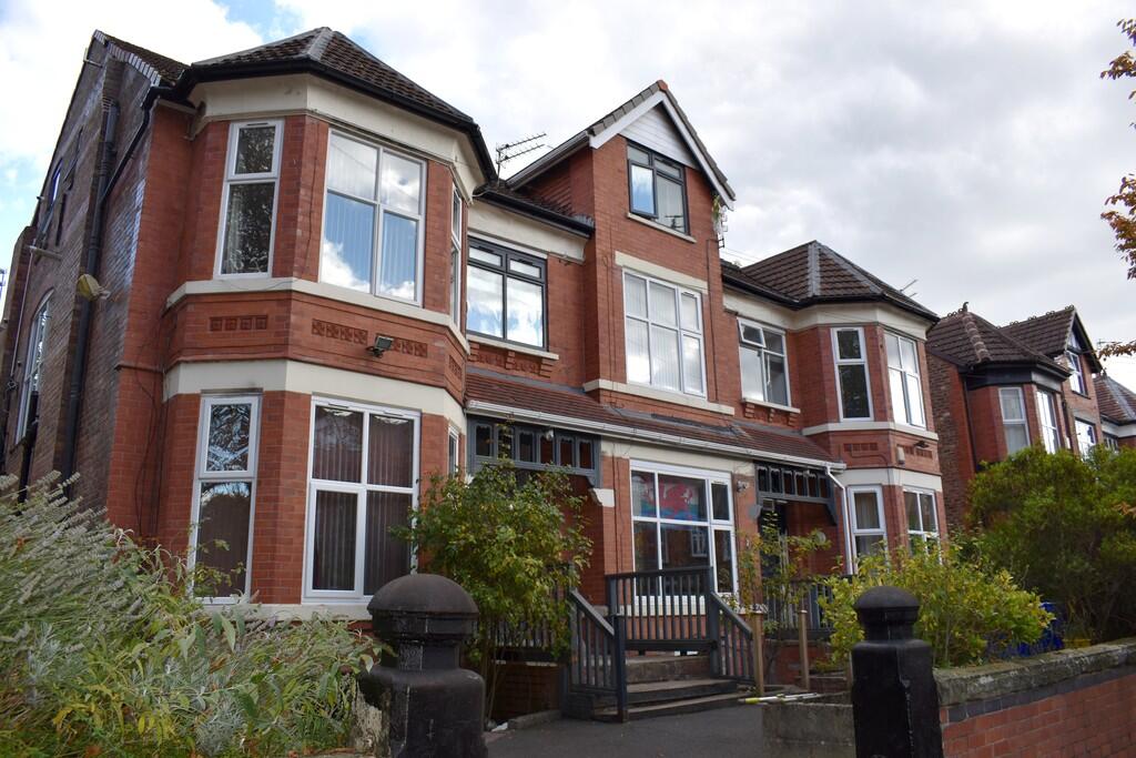
Moorfield Road
Manchester, M20 2UY
Property details
Tenure
FREEHOLD
Local average
£259,131 (+710.4%)
Deprivation
Decile 9 (27,669 of 33,755)
Street crime
0 incidents within 1 mile (Apr 2026)
Key features
- INVESTMENT OPPORTUNITY
- Freehold block of 14 apartments
- Located in Wests Disbury
- Close to Transport Links to Manchester City Centre
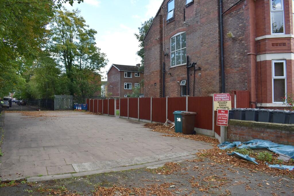
- Communal Gardens
- Off road parking
Additional details
- Electricity
- Mains supply
- Water
- Mains supply
- Sewerage
- Mains supply
- Heating
- Gas central
- Parking
- Off street
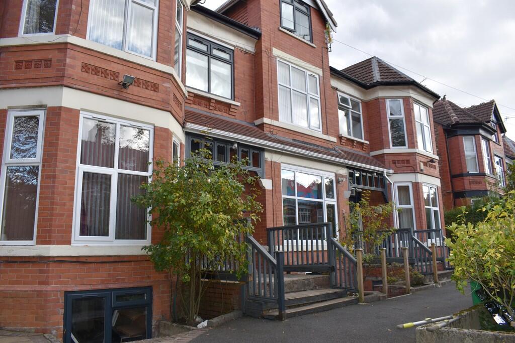
Description
14 Apartments with off road parking and communal gardens, comprising:
10 x studio apartments
2x one bedroom apartments
2 x three bedroom apartment
Situated in a detached block
Located in the West Didsbury area of Manchester
0.5 miles from Burton Road Tram Station
Currently fully let, producing a passing rent of c.£125,000 per annum
We are of the opinion that there is an opportunity to increase the rental income to an Estimated Rental Value in the region of c.£140,000 per annum
Listed by
Manchester
MCR Move Ltd
Reference: 169191161
EPC ratings on this postcode
We don't have a matched EPC for this property yet. Below are efficiency scores and details for other addresses on this postcode.
| Address | Current | Potential | Floor area | Age band | Type |
|---|---|---|---|---|---|
| 14 MOORFIELD ROAD, MANCHESTER | 57 | 73 | 276 m² | England and Wales: 1900-1929 | House |
| 14 MOORFIELD ROAD, MANCHESTER, MANCHESTER | 57 | 73 | 276 m² | England and Wales: 1900-1929 | Detached |
| 16 Moorfield Road | 67 | 80 | 357 m² | England and Wales: 1900-1929 | House |
| 16 Moorfield Road, MANCHESTER | 67 | 80 | 357 m² | England and Wales: 1900-1929 | Detached |
| 16, Moorfield Road | 65 | 70 | 289 m² | England and Wales: 1900-1929 | House |
| 16, Moorfield Road | 51 | 71 | 363 m² | England and Wales: 1900-1929 | House |
| 16, Moorfield Road, MANCHESTER | 51 | 71 | 363 m² | England and Wales: 1900-1929 | Detached |
| 18 MOORFIELD ROAD, MANCHESTER | 55 | 82 | 247 m² | England and Wales: 1930-1949 | House |
| 18 MOORFIELD ROAD, MANCHESTER, MANCHESTER | 55 | 82 | 247 m² | England and Wales: 1930-1949 | Detached |
| 22, Moorfield Road | 65 | 76 | 404 m² | England and Wales: 1930-1949 | House |
| 22, Moorfield Road, MANCHESTER | 65 | 76 | 404 m² | England and Wales: 1930-1949 | Detached |
| 24 Moorfield Road | 67 | 80 | 344 m² | England and Wales: 1900-1929 | House |
| 24 Moorfield Road, MANCHESTER | 67 | 80 | 344 m² | England and Wales: 1900-1929 | Detached |
| 26, Moorfield Road | 70 | 78 | 338 m² | England and Wales: 1900-1929 | House |
| 26, Moorfield Road, MANCHESTER | 70 | 78 | 338 m² | England and Wales: 1900-1929 | Detached |
Flood risk
Zone: 1
Risk: Low
Job (default Low)
Floorplans
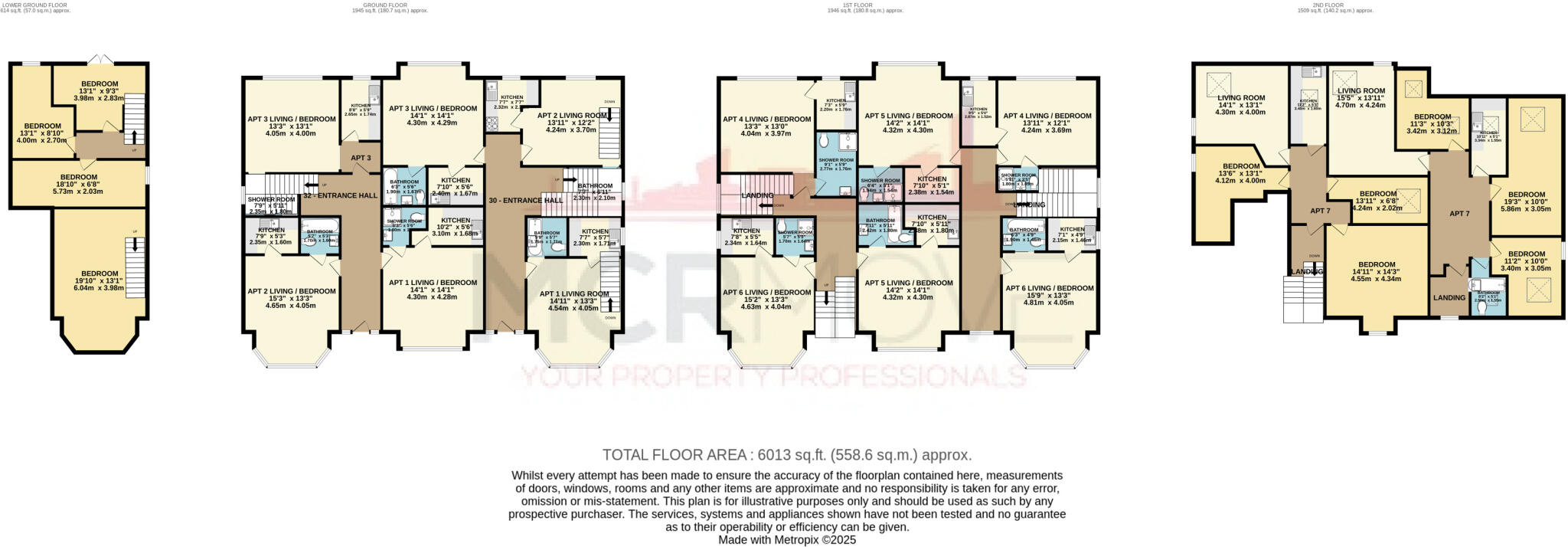
Floorplan 1
Price history
| Event | Date | Price | % change |
|---|---|---|---|
| Listed for sale | — | £2,100,000 | — |
Source: HM Land Registry Price Paid Data. Crown copyright.
Sold Comparables
Same street and nearby sales within 0.25 miles (last 5 years). Data from Land Registry Price Paid.
| Address | Price | Date | Type |
|---|---|---|---|
| 31 BARLOW MOOR COURT, MANCHESTER, GREATER MANCHESTER, M20 2UU | £252,000 | 05/01/2026 | Flat |
| 1 FLAT 7 THE BEECHES, MANCHESTER, GREATER MANCHESTER, M20 2BG | £300,000 | 19/12/2025 | Flat |
| LINDALE HOUSE, 8 FLAT 4 THE BEECHES, MANCHESTER, GREATER MANCHESTER, M20 2BG | £292,000 | 15/12/2023 | Flat |
| IRNODALE, 11 FLAT 3 THE BEECHES, MANCHESTER, GREATER MANCHESTER, M20 2FR | £192,000 | 28/07/2023 | Flat |
| OAKWOOD HOUSE, 150 FLAT 6 BARLOW MOOR ROAD, MANCHESTER, GREATER MANCHESTER, M20 2UT | £390,000 | 17/07/2023 | Flat |
| 1 FLAT 7 THE BEECHES, MANCHESTER, GREATER MANCHESTER, M20 2BG | £306,000 | 22/06/2023 | Flat |
| HIGHOVER HOUSE FLAT 2 THE BEECHES, MANCHESTER, GREATER MANCHESTER, M20 2BG | £252,000 | 26/05/2023 | Flat |
| IRNODALE, 11 FLAT 8 THE BEECHES, MANCHESTER, GREATER MANCHESTER, M20 2FR | £185,000 | 16/12/2022 | Flat |
| LINDEN COURT, 10 FLAT 9 THE BEECHES, MANCHESTER, GREATER MANCHESTER, M20 2FR | £310,000 | 12/12/2022 | Flat |
| OAKWOOD HOUSE, 150 FLAT 1 BARLOW MOOR ROAD, MANCHESTER, GREATER MANCHESTER, M20 2UT | £290,000 | 25/11/2022 | Flat |
| WESSEX LODGE, 15 APARTMENT 8 THE BEECHES, MANCHESTER, GREATER MANCHESTER, M20 2FR | £230,000 | 26/10/2022 | Flat |
| 148 FLAT 1 BARLOW MOOR ROAD, MANCHESTER, GREATER MANCHESTER, M20 2UT | £290,000 | 08/07/2022 | Flat |
| 4A WARWICK AVENUE, MANCHESTER, GREATER MANCHESTER, M20 2LL | £240,000 | 08/06/2022 | Flat |
| WESSEX LODGE, 13 APARTMENT 23 THE BEECHES, MANCHESTER, GREATER MANCHESTER, M20 2FR | £158,000 | 05/05/2022 | Flat |
| IRNODALE, 11 FLAT 10 THE BEECHES, MANCHESTER, GREATER MANCHESTER, M20 2FR | £260,000 | 07/04/2022 | Flat |
| HIGHOVER HOUSE FLAT 7 THE BEECHES, MANCHESTER, GREATER MANCHESTER, M20 2BG | £191,000 | 01/04/2022 | Flat |
| 38 BARLOW MOOR COURT, MANCHESTER, GREATER MANCHESTER, M20 2UX | £230,000 | 01/04/2022 | Flat |
| 148 FLAT 8 BARLOW MOOR ROAD, MANCHESTER, GREATER MANCHESTER, M20 2UT | £221,500 | 31/03/2022 | Flat |
| OAKWOOD HOUSE, 150 FLAT 2 BARLOW MOOR ROAD, MANCHESTER, GREATER MANCHESTER, M20 2UT | £320,000 | 25/03/2022 | Flat |
| 2 FLAT 2 THE BEECHES, MANCHESTER, GREATER MANCHESTER, M20 2BG | £175,000 | 17/02/2022 | Flat |
| Same street 8 FLAT 6 MOORFIELD ROAD, MANCHESTER, GREATER MANCHESTER, M20 2UY | £347,890 | 31/01/2022 | Flat |
| Same street 6 FLAT 6 MOORFIELD ROAD, MANCHESTER, GREATER MANCHESTER, M20 2UY | £257,000 | 24/01/2022 | Flat |
| Same street 8 FLAT 1 MOORFIELD ROAD, MANCHESTER, GREATER MANCHESTER, M20 2UY | £346,000 | 24/09/2021 | Flat |
Street average: £316,963 (3 sales)
Area average: £254,225 (20 sales)
Capital growth trend
Land Registry outcode average: last 12 months vs 5y and 10y ago (from sold prices).
House Price Index (HM Land Registry — official index, not sold-price averages): Manchester. Series: Flats and maisonettes. As of March 2026.
Rental Range
Estimated market rent for Manchester. Low = conservative, Realistic = average, Optimistic = best case.
Based on Local Authority from postcode lookup → Manchester.
LHA (30th percentile) floor for Central Greater Manchester: £1,346/mo (Apr 2025 – Mar 2026)
Location
Address
Moorfield Road
Nearby
Nearest stations, universities and amenities (distance from property).
| Type | Name | Distance |
|---|---|---|
| Bus stop | West Didsbury, Barlow Moor Road / near Barlow Moor Court (Stop D) | 0.1 miles |
| Bus stop | West Didsbury, Burton Road / Barlow Moor Road (Stop C) | 0.1 miles |
| Hospital | Withington Community Hospital | 0.1 miles |
| Hospital | Spire Manchester Hospital | 0.2 miles |
| Shop | Co-op | 0.3 miles |
| Shop | Brandon May | 0.3 miles |
| Train station | Burnage | 1.4 miles |
| Train station | East Didsbury | 1.5 miles |
| University | Fallowfield Reception and Richmond Amenities Building | 2.0 miles |
| University | University of Manchester Fallowfield Campus | 2.1 miles |
Street-level crime
| Category | Count |
|---|---|
| Total incidents | 0 |
Within 1 mile during Apr 2026. Source: data.police.uk (England & Wales).
Schools nearby
Nearest open schools with Ofsted ratings (England). Closed schools are not shown. Data from Get Information about Schools and Ofsted.
| Name | Type | Distance | Ofsted |
|---|---|---|---|
| Lancasterian School | Other | 0.1 miles | Good — 11 Sep 2019 |
| Manchester Muslim Preparatory School | Other | 0.2 miles | Good — 13 Mar 2018 |
| The Birches School | Other | 0.2 miles | Good — 30 Jun 2024 |
| Moor Allerton Preparatory School | Other | 0.3 miles | — (No rating) |
| Didsbury High School | Secondary | 0.4 miles | Outstanding — 10 Mar 2024 |
Rental Comparables
Loading rental comparables for this postcode. Refresh in a few minutes.
Rent-driven metrics
Based on Area rent estimate.
- Rent ratio — Monthly rent ÷ purchase price (1% rule). 1%+ = strong, 0.8–1% = okay, <0.8% = weak for cashflow.
- Max investor price — Rent ÷ 0.8%; the price at which rent would be 0.8% of price (Stoke-style target).
- Target investor price — Rent ÷ 1%; the price at which rent would be 1% of price (strong cashflow band).
- Gross yield — Annual rent as % of purchase price (no costs).
Enter House Number
Enter the house number to help us retrieve more accurate pricing history and property data.
Please log in to submit or correct the house number for this listing.
Log in to continue