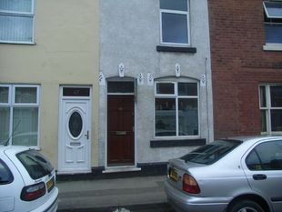
49 MINER STREET
WALSALL, WEST MIDLANDS WS2 8QN
£410 pcm
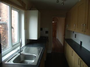
Property details
Floor area
86 m²
EPC rating
D
Year built
England and Wales: before 1900
Deprivation
Decile 1 (1,553 of 33,755)
Street crime
574 incidents within 1 mile (Apr 2026)
Additional details
- Garden
- Yes
Description
Listed by
Walsall
Edwards Moore
Reference: 23952758
EPC Rating & Upgrade Cost
Current rating: D
Potential rating: C
Inspection date: 10/07/2023
Expiry date: 09/07/2033
Current heating cost: £1,600/year
Potential heating cost: £1,519/year
Est. upgrade cost to C: £9,900
Recommendations
- Upgrade heating controls (£350 - £450)
- Solar water heating (£4,000 - £6,000)
- Solar photovoltaic panels, 2.5 kWp (£3,500 - £5,500)
Flood risk
Zone: 1
Risk: Low
Job (default Low)
FENSA Certificates
This property has 1 FENSA certificate(s) on record, indicating window/door installations by FENSA-approved installers.
FENSA Certificate #1935957
Property Details
Street: 49 Miner Street
Town: BIRCHILLS
Postcode: WS2 8QN
Installation Details
Items: 6 windows
Certificate Issued: 09/08/2004
Work Completed: 07/07/2004
This certificate data was retrieved from FENSA's database
What is FENSA? FENSA (Fenestration Self-Assessment Scheme) is a government-authorised scheme that monitors building regulation compliance for replacement windows and doors. Certificates indicate that work was completed by FENSA-approved installers.
Rental Range
Estimated market rent for Walsall. Low = conservative, Realistic = average, Optimistic = best case.
Based on Local Authority from postcode lookup → Walsall.
LHA (30th percentile) floor for Black Country: £623/mo (Apr 2025 – Mar 2026)
Location
Nearby
Nearest stations, universities and amenities (distance from property).
| Type | Name | Distance |
|---|---|---|
| Bus stop | Hollyhedge Lane / Bentley Lane | 0.1 miles |
| Shop | Buraq Supermarket | 0.3 miles |
| Shop | Touchwood Pharmacy | 0.3 miles |
| Hospital | Walsall Manor Hospital | 0.7 miles |
| Hospital | Dorothy Pattison Hospital | 0.7 miles |
| Train station | Walsall | 0.8 miles |
| Train station | Darlaston | 1.5 miles |
| University | University of Wolverhampton, Walsall Campus | 1.8 miles |
| University | Dudley Port School | 5.2 miles |
Street-level crime
| Category | Count |
|---|---|
| Violence and sexual offences | 208 |
| Shoplifting | 105 |
| Criminal damage and arson | 44 |
| Vehicle crime | 37 |
| Burglary | 33 |
| Public order | 32 |
| Other theft | 28 |
| Drugs | 24 |
| Possession of weapons | 15 |
| Anti-social behaviour | 13 |
| Other crime | 11 |
| Robbery | 11 |
| Theft from the person | 7 |
| Bicycle theft | 6 |
| Total incidents | 574 |
Within 1 mile during Apr 2026. Source: data.police.uk (England & Wales).
Schools nearby
Nearest open schools with Ofsted ratings (England). Closed schools are not shown. Data from Get Information about Schools and Ofsted.
| Name | Type | Distance | Ofsted |
|---|---|---|---|
| Croft Academy | Primary | 0.3 miles | — (Inspected (no overall grade)) |
| Reedswood E-ACT Academy | Primary | 0.3 miles | Good — 28 Jun 2016 |
| Birchills Church of England Community Academy | Primary | 0.4 miles | Good — 14 May 2024 |
| Emmanuel School | Other | 0.4 miles | Requires improvement — 27 Feb 2020 |
| St Patrick's Catholic Primary School, Walsall | Primary | 0.5 miles | Good — 6 Dec 2016 |
Rental Comparables
Residential lets from OpenRent and Rightmove for the area (same bedroom count). Use to validate rent estimates. Student lets are excluded.
| Title | Rent | Beds | Distance | As seen on |
|---|---|---|---|---|
| 2 Bed Flat, White St, WS1 | £800/mo | 2 | 1.16 miles | OpenRent |
Average rent: £800/mo (1 listing)