Flat 2
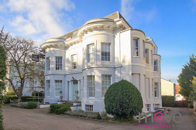
OSBORNE LODGE, 99, THE PARK, CHELTENHAM, GLOUCESTERSHIRE GL50 2RW
£650 pcm
Property details
Floor area
130 m²
Council tax band
A
Year built
England and Wales: before 1900
Deprivation
Decile 10 (32,969 of 33,755)
Street crime
3 incidents within 1 mile (Apr 2026)
Key features
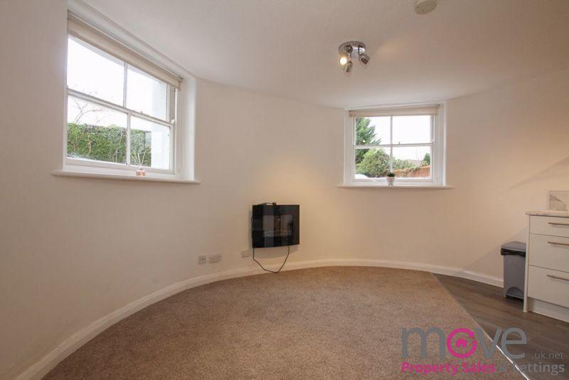
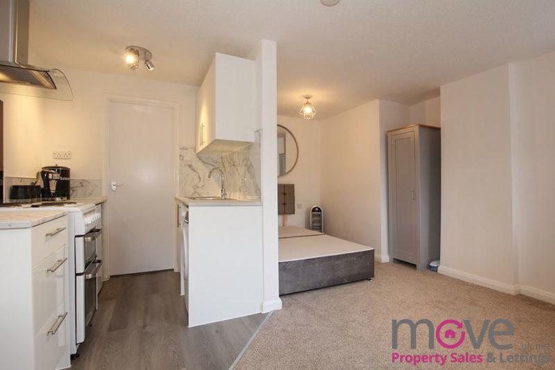
- Part Furnished Studio Apartment
- Newly Decorated
- Located in Stylish Grade II Listed Building
- Popular Location Close to Amenities
- Allocated Off Road Parking
- Minimum Term 12 Months
- Council Tax Band A
- Available Now
Additional details
- Parking
- Yes
Description
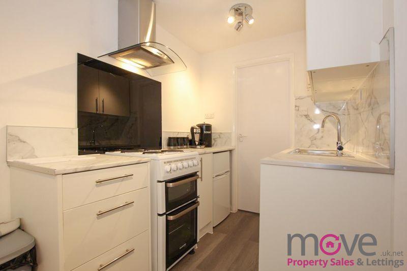
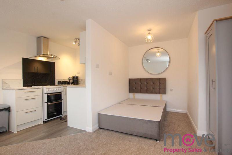
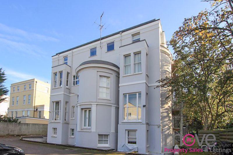
Set within an attractive Grade II listed building, the studio accommodation comprises; Kitchen with a range of wall and base units and white goods. The living/sleeping area is set within a charming semi-circular room which has been recently decorated and features dual aspect sash windows and space for additional furniture.
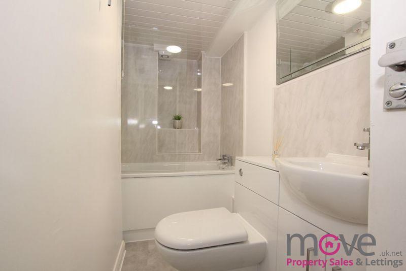
The bathroom comprises a white three piece suite.Outside, the property benefits from the use of an allocated off road parking space.
Available From January 2023.
For more details or to book a viewing, please call Move.
A holding deposit equivalent of one weeks rent is required to secure the property. This amount goes towards the first month’s rent.Deposit payable will be equivalent to five weeks rent.
Listed by
Cheltenham
move.uk.net
Reference: 130110947
EPC ratings on this postcode
We don't have a matched EPC for this property yet. Below are efficiency scores and details for other addresses on this postcode.
| Address | Current | Potential | Floor area | Age band | Type |
|---|---|---|---|---|---|
| 103, The Park, CHELTENHAM | 76 | 82 | 217 m² | England and Wales: 2003-2006 | Detached |
| 103a The Park, CHELTENHAM | 75 | 81 | 211 m² | England and Wales: 2003-2006 | Detached |
| 104, The Park, CHELTENHAM | 60 | 75 | 119 m² | England and Wales: 1983-1990 | Detached |
| 109 The Park, CHELTENHAM | 54 | 74 | 356 m² | England and Wales: before 1900 | Detached |
| 87, The Park, CHELTENHAM | 66 | 81 | 145 m² | England and Wales: 1950-1966 | Terraced |
| 89, The Park, CHELTENHAM | 65 | 84 | 110 m² | England and Wales: 1967-1975 | Terraced |
| 97, The Park, CHELTENHAM | 66 | 79 | 132 m² | — | Detached |
| 97, The Park, CHELTENHAM | 56 | 78 | 132 m² | — | Detached |
| Flat 1, 115, The Park, CHELTENHAM | 76 | 79 | 65 m² | England and Wales: 2003-2006 | Flat |
| FLAT 10, 115 THE PARK, CHELTENHAM, CHELTENHAM | 80 | 81 | 84 m² | England and Wales: 2003-2006 | Flat |
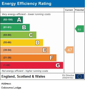
| Flat 10, Osbourne House, 99, The Park, CHELTENHAM | 40 | 81 | 62 m² | England and Wales: before 1900 | Flat |
| Flat 11, 115, The Park, CHELTENHAM | 70 | 72 | 85 m² | England and Wales: 1996-2002 | Flat |
| Flat 11, Osbourne Lodge, 99 The Park, CHELTENHAM | 61 | 85 | 51 m² | England and Wales: before 1900 | Flat |
| Flat 12, 115, The Park, CHELTENHAM | 75 | 78 | 80 m² | England and Wales: 1996-2002 | Flat |
| Flat 12, Tivoli Mansions 115 The Park, Cheltenham | 70 | 73 | 69 m² | England and Wales: 2003-2006 | Flat |
Flood risk
Zone: 1
Risk: Low
Job (default Low)
Floorplans
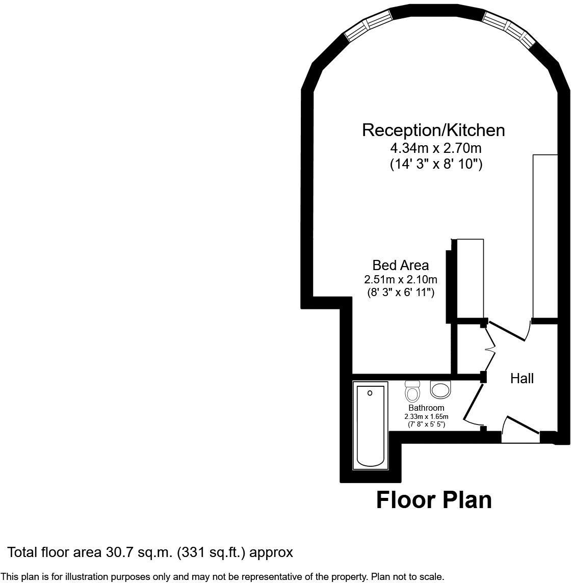
Floorplan 1
EPC Graphs
Energy Performance Certificate
Rental Range
Estimated market rent for Cheltenham. Low = conservative, Realistic = average, Optimistic = best case.
Based on Local Authority from postcode lookup → Cheltenham.
LHA (30th percentile) floor for Cheltenham: Apr 2025 – Mar 2026
Location
Address
The Park
Nearby
Nearest stations, universities and amenities (distance from property).
| Type | Name | Distance |
|---|---|---|
| Bus stop | Park Campus | 0.1 miles |
| Bus stop | St Stephen's Road | 0.1 miles |
| University | Park Campus | 0.1 miles |
| Shop | ATB Guitars | 0.2 miles |
| Shop | Groves Batteries | 0.3 miles |
| Train station | Cheltenham Spa | 0.8 miles |
| Hospital | NHS Records Office | 0.9 miles |
| Hospital | Estates Workshop | 1.0 miles |
| University | Francis Close Hall | 1.3 miles |
| Train station | Cheltenham Racecourse | 2.7 miles |
Street-level crime
| Category | Count |
|---|---|
| Violence and sexual offences | 2 |
| Anti-social behaviour | 1 |
| Total incidents | 3 |
Within 1 mile during Apr 2026. Source: data.police.uk (England & Wales).
Schools nearby
Nearest open schools with Ofsted ratings (England). Closed schools are not shown. Data from Get Information about Schools and Ofsted.
| Name | Type | Distance | Ofsted |
|---|---|---|---|
| University of Gloucestershire | Other | 0.1 miles | — (No rating) |
| St James' Church of England Primary School | Primary | 0.3 miles | Good — 16 Nov 2023 |
| Bettridge School | Other | 0.4 miles | Good — 27 Feb 2017 |
| Belmont School | Other | 0.4 miles | Outstanding — 14 Jan 2015 |
| Cheltenham Bournside School and Sixth Form Centre | Secondary | 0.5 miles | Good — 27 Nov 2022 |
Rental Comparables
Residential lets from OpenRent and Rightmove for the area. Bedroom counts vary — use the Beds column to compare like-for-like lets. Student lets are excluded.
| Title | Rent | Beds | Distance | As seen on |
|---|---|---|---|---|
| 2 Bed Terraced House, Bronte Close, GL51 | £1,150/mo | 2 | 0.77 miles | OpenRent |
| 2 Bed End Terrace, Camellia Court, GL51 | £1,350/mo | 2 | 0.78 miles | OpenRent |
Average rent: £1,250/mo (2 listings)
Enter House Number
Enter the house number to help us retrieve more accurate pricing history and property data.
Please log in to submit or correct the house number for this listing.
Log in to continue