Land Adjacent To Water Lane
Newport, TF10 7LD
£975,000
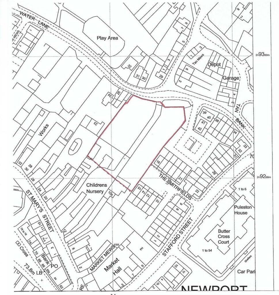
Photo 1
/ 1
Property details
Tenure
FREEHOLD
Local average
£426,053 (+128.8%)
Deprivation
Decile 6 (17,580 of 33,755)
Street crime
61 incidents within 1 mile (May 2026)
Key features
- 1 acre of development land
- Suitable for residential or commercial development
- Walking distance to Newport town centre and all its amenities
Description
Newport is a thriving market town, which features a diverse range of independent shops, larger chain style stores, supermarkets (including Waitrose), and a variety of leisure facilities. There is a selection of highly regarded primary and secondary schools to choose from, all with excellent OFSTED ratings, including two selective secondary schools (Haberdashers Adams' Grammar School and Newport High School for Girls) and the highly acclaimed Harper Adams University. The market town of The property is within easy commuting distance of Telford (10 miles), Stafford (16 miles) and Shrewsbury (19 miles), all with mainline train stations, wider ranges of shops and leisure facilities, as well as being within close proximity to the M54 J4 (9 miles).
AGENTS' NOTES:
SERVICES: We are advised that there are all main services are available in the area. It will be the responsibility of the purchaser to connect the services at their expense. Davies White & Perry have not tested any apparatus, equipment, fittings etc or services to this property, so cannot confirm that they are in working order or fit for purpose. A buyer is recommended to obtain confirmation from their Surveyor or Solicitor.
LOCAL AUTHORITY: Telford & Wrekin Council.
PROPERTY INFORMATION: We believe this information to be accurate, but it cannot be guaranteed. The fixtures, fittings, appliances and mains services have not been tested. If there is any point which is of particular importance please obtain professional confirmation. All measurements quoted are approximate. These particulars do not constitute a contract or part of a contract.
AML REGULATIONS: To ensure compliance with the latest Anti Money Laundering Regulations all intending purchasers must produce identification documents prior to the issue of sale confirmation. We may use an online service provider to also confirm your identity. A list of acceptable ID documents is available upon request.
TENURE: We are advised that the property is Freehold and this will be confirmed by the Vendors Solicitor during the Pre- Contract Enquiries. Vacant possession upon completion.
METHOD OF SALE: For Sale by Private Treaty.
TO VIEW THIS PROPERTY: Please contact our Newport Office, 45/47 High Street, Newport, TF10 7AT on or email us at
DIRECTIONS: From our office in the High Street, proceed along the High Street to the roundabout with the Barley public house. take the second exit. At the traffic lights turn turn left onto Water Lane and the land is situated on the left hand side after The Smithfield's development.
Listed by
Newport
Davies White & Perry
Reference: 172812782
EPC ratings on this postcode
We don't have a matched EPC for this property yet. Below are efficiency scores and details for other addresses on this postcode.
| Address | Current | Potential | Floor area | Age band | Type |
|---|---|---|---|---|---|
| 10, Water Lane | 60 | 88 | 64 m² | England and Wales: before 1900 | House |
| 10, Water Lane, NEWPORT | 60 | 88 | 64 m² | England and Wales: before 1900 | Detached |
| 11 Water Lane, NEWPORT | 60 | 77 | 113 m² | England and Wales: before 1900 | Detached |
| 11, Water Lane | 40 | 78 | 91 m² | England and Wales: before 1900 | House |
| 11, Water Lane, NEWPORT | 40 | 78 | 91 m² | England and Wales: before 1900 | Detached |
| 16, Water Lane | 62 | 88 | 78 m² | England and Wales: before 1900 | House |
| 16, Water Lane, NEWPORT | 62 | 88 | 78 m² | England and Wales: before 1900 | Detached |
| 17 Water Lane | 62 | 86 | 82 m² | England and Wales: before 1900 | House |
| 17 Water Lane, NEWPORT | 62 | 86 | 82 m² | England and Wales: before 1900 | Detached |
| 25, Water Lane | 43 | 61 | 58 m² | England and Wales: before 1900 | House |
| 25, Water Lane, NEWPORT | 43 | 61 | 58 m² | England and Wales: before 1900 | Detached |
| 30, Water Lane | 55 | 84 | 67 m² | England and Wales: 1900-1929 | House |
| 30, Water Lane, NEWPORT | 55 | 84 | 67 m² | England and Wales: 1900-1929 | Detached |
| 31 WATER LANE | 69 | 89 | 75 m² | England and Wales: 1900-1929 | House |
| 31 WATER LANE, NEWPORT | 69 | 89 | 75 m² | England and Wales: 1900-1929 | Detached |
Flood risk
Zone: 1
Risk: Low
Job (default Low)
Floorplans
Floorplan 1
Price history
| Event | Date | Price | % change |
|---|---|---|---|
| Listed for sale | — | £975,000 | — |
Source: HM Land Registry Price Paid Data. Crown copyright.
Sold Comparables
Sold comparables data is not available for this property.
Capital growth trend
Land Registry outcode average: last 12 months vs 5y and 10y ago (from sold prices).
House Price Index (HM Land Registry — official index, not sold-price averages): Telford and Wrekin. Series: Detached. As of April 2026.
Rental Range
Estimated market rent for Telford and Wrekin. Low = conservative, Realistic = average, Optimistic = best case.
Based on Local Authority from postcode lookup → Telford and Wrekin.
LHA (30th percentile) floor for Shropshire: Apr 2025 – Mar 2026
Location
Address
Water Lane
Nearby
Nearest stations, universities and amenities (distance from property).
| Type | Name | Distance |
|---|---|---|
| Bus stop | Unknown | 0.0 miles |
| Bus stop | Adams Grammar School | 0.1 miles |
| Shop | TFM Farm and Country Superstore | 0.2 miles |
| Shop | Costcutter | 0.2 miles |
| University | Harper Adams University | 2.1 miles |
| Hospital | Shrewsbury & Telford Hospital NHS Trust Sterile Services Department (SSD) | 5.7 miles |
| Train station | Oakengates | 6.1 miles |
| University | University Of Wolverhampton (Shropshire Campus) (Business School) | 6.4 miles |
| Train station | Telford Central | 6.7 miles |
| Hospital | Bickerstaff Endoscopy Unit | 6.8 miles |
Street-level crime
| Category | Count |
|---|---|
| Violence and sexual offences | 32 |
| Criminal damage and arson | 8 |
| Other theft | 7 |
| Shoplifting | 5 |
| Public order | 4 |
| Other crime | 2 |
| Burglary | 1 |
| Robbery | 1 |
| Vehicle crime | 1 |
| Total incidents | 61 |
Within 1 mile during May 2026. Source: data.police.uk (England & Wales).
Schools nearby
Nearest open schools with Ofsted ratings (England). Closed schools are not shown. Data from Get Information about Schools and Ofsted.
| Name | Type | Distance | Ofsted |
|---|---|---|---|
| Haberdashers' Castle House School | Other | 0.1 miles | — (No rating) |
| Haberdashers' Adams | Secondary | 0.1 miles | Good — 27 Jun 2022 |
| Newport Church of England Voluntary Controlled Junior School | Primary | 0.4 miles | Good — 18 Jan 2024 |
| St Peter and St Paul Catholic Primary School | Primary | 0.5 miles | Outstanding — 20 Dec 2012 |
| Newport Girls' High School Academy | Secondary | 0.6 miles | Outstanding — 7 Dec 2022 |
Rental Comparables
Loading rental comparables for this postcode. Refresh in a few minutes.
Rent-driven metrics
Based on Area rent estimate.
- Rent ratio — Monthly rent ÷ purchase price (1% rule). 1%+ = strong, 0.8–1% = okay, <0.8% = weak for cashflow.
- Max investor price — Rent ÷ 0.8%; the price at which rent would be 0.8% of price (Stoke-style target).
- Target investor price — Rent ÷ 1%; the price at which rent would be 1% of price (strong cashflow band).
- Gross yield — Annual rent as % of purchase price (no costs).
Enter House Number
Enter the house number to help us retrieve more accurate pricing history and property data.
Please log in to submit or correct the house number for this listing.
Log in to continue