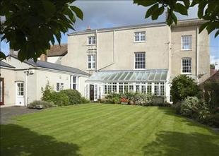
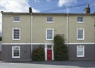
Glaisters
CHURCH WALK, BRISTOL, WRINGTON, NORTH SOMERSET BS40 5QQ
Property details
Last sold
£740,000 Nov 2007
Local average
£585,000 (+30.8%)
Deprivation
Decile 8 (26,267 of 33,755)
Street crime
9 incidents within 1 mile (May 2026)
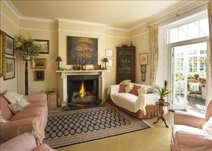
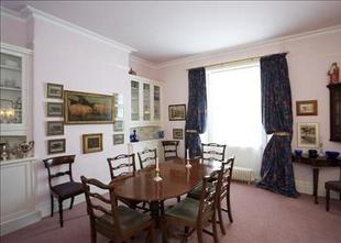
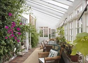
Key features
- 5 bedrooms
- 3 reception rooms
- 3 bathrooms
- Outbuildings
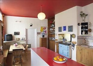
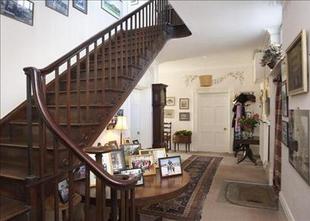
Description
Listed by
Bristol
Knight Frank
Reference: 15155444
EPC ratings on this postcode
We don't have a matched EPC for this property yet. Below are efficiency scores and details for other addresses on this postcode.
| Address | Current | Potential | Floor area | Age band | Type |
|---|---|---|---|---|---|
| 3, Church Walk, Wrington, BRISTOL | 68 | 71 | 167 m² | — | Detached |
| Mulberry Cottage, Church Walk, Wrington, BRISTOL | 36 | 59 | 331 m² | England and Wales: before 1900 | Detached |
| The Dower House, Church Walk, Wrington, BRISTOL | 62 | 74 | 325 m² | England and Wales: 1991-1995 | Detached |
| The Dower House, Church Walk, Wrington, BRISTOL | 42 | 71 | 304 m² | — | Detached |
Flood risk
Zone: 1
Risk: Low
Job (default Low)
Price history
| Event | Date | Price | % change |
|---|---|---|---|
| Sold | 01/11/2007 (18 years ago) | £740,000 | — |
Source: HM Land Registry Price Paid Data. Crown copyright.
Sold Comparables
Same street and nearby sales within 0.25 miles (last 5 years). Data from Land Registry Price Paid.
| Address | Price | Date | Type |
|---|---|---|---|
| Same street THE DOWER HOUSE CHURCH WALK, WRINGTON, BRISTOL, NORTH SOMERSET, BS40 5QQ | £1,450,000 | 08/03/2023 | Detached |
| Same street MULBERRY COTTAGE CHURCH WALK, WRINGTON, BRISTOL, NORTH SOMERSET, BS40 5QQ | £1,550,000 | 07/03/2023 | Detached |
| 1 BROAD STREET, WRINGTON, BRISTOL, NORTH SOMERSET, BS40 5LA | £100,000 | 02/12/2022 | Other |
Street average: £1,500,000 (2 sales)
Area average: £100,000 (1 sale)
Capital growth trend
House Price Index (HM Land Registry — official index, not sold-price averages): North Somerset. Series: All dwelling types. As of April 2026.
Rental Range
Estimated market rent for North Somerset. Low = conservative, Realistic = average, Optimistic = best case.
Based on Local Authority from postcode lookup → North Somerset.
LHA (30th percentile) floor for Bath: £1,940/mo (Apr 2025 – Mar 2026)
Location
Address
Church Walk
Nearby
Nearest stations, universities and amenities (distance from property).
| Type | Name | Distance |
|---|---|---|
| Shop | Buglers | 0.1 miles |
| Bus stop | Golden Lion | 0.1 miles |
| Shop | Zero Waste Pantry | 0.1 miles |
| Bus stop | Kings Road | 0.3 miles |
| University | University of Bristol Langford Campus | 1.3 miles |
| Train station | Yatton | 3.5 miles |
| Train station | Nailsea and Backwell | 4.1 miles |
| University | University of Bristol | 5.2 miles |
| Hospital | Cygnet Hospital Kewstoke | 8.6 miles |
| Hospital | The Chesterfield | 9.0 miles |
Street-level crime
| Category | Count |
|---|---|
| Violence and sexual offences | 4 |
| Burglary | 2 |
| Vehicle crime | 2 |
| Public order | 1 |
| Total incidents | 9 |
Within 1 mile during May 2026. Source: data.police.uk (England & Wales).
Schools nearby
Nearest open schools with Ofsted ratings (England). Closed schools are not shown. Data from Get Information about Schools and Ofsted.
| Name | Type | Distance | Ofsted |
|---|---|---|---|
| Wrington Church of England Primary School | Primary | 0.2 miles | Outstanding — 3 Jul 2015 |
| Churchill Church of England Primary School | Primary | 1.7 miles | Good — 19 May 2014 |
| Burrington Church of England Primary School | Primary | 2.1 miles | Good — 24 Apr 2014 |
| St Andrew's CofE Primary School | Primary | 2.3 miles | Good — 9 Jan 2013 |
| Court-De-Wyck Church School | Primary | 2.5 miles | Good — 4 Feb 2011 |
Rental Comparables
Rental comparables are temporarily unavailable while listing-site fetches are paused. Try again later.
Rent-driven metrics
Based on Area rent estimate.
- Rent ratio — Monthly rent ÷ purchase price (1% rule). 1%+ = strong, 0.8–1% = okay, <0.8% = weak for cashflow.
- Max investor price — Rent ÷ 0.8%; the price at which rent would be 0.8% of price (Stoke-style target).
- Target investor price — Rent ÷ 1%; the price at which rent would be 1% of price (strong cashflow band).
- Gross yield — Annual rent as % of purchase price (no costs).
Enter House Number
Enter the house number to help us retrieve more accurate pricing history and property data.
Please log in to submit or correct the house number for this listing.
Log in to continue