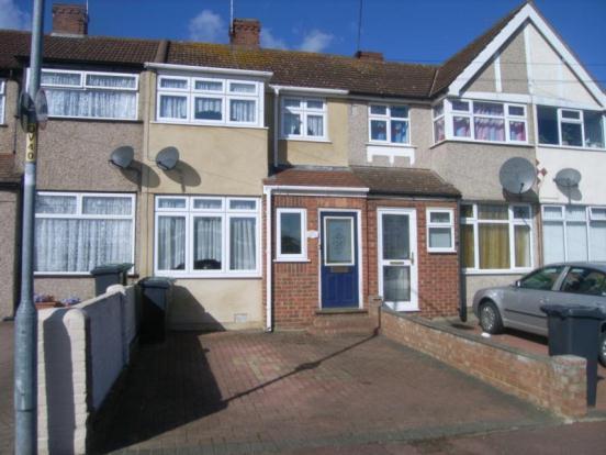
262 OVAL ROAD NORTH
DAGENHAM, GREATER LONDON RM10 9EJ
£167,000
Property details
Tenure
FREEHOLD
Floor area
67 m²
EPC rating
D
Year built
England and Wales: 1930-1949
Last sold
£164,500 Apr 2013
Price per m²
£2,493/m²
Local average
£379,682 (-56%)
Deprivation
Decile 3 (8,110 of 33,755)
Street crime
315 incidents within 1 mile (Apr 2026)
Additional details
- Parking
- Yes
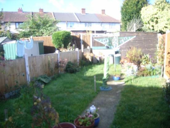
- Garden
- Yes
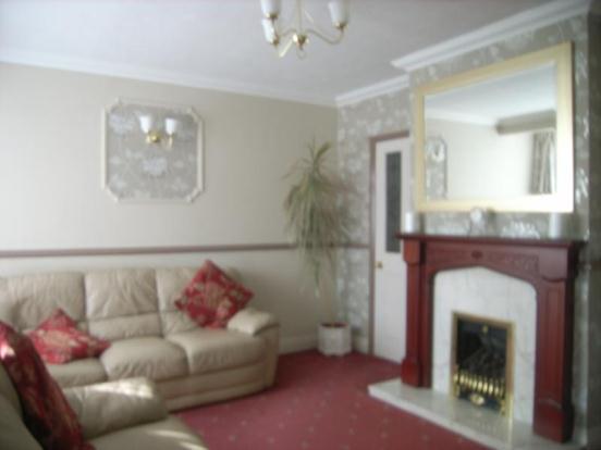
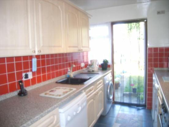
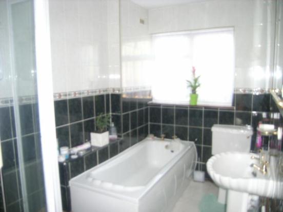
Description
Entrance Storm Porch
Lounge 13'1 x 10'3
Dining Room 10'9 x 9'2
Fitted Kitchen 9'8 x 7'0
Bathroom wc 9'1 x 5'7
Gas Central Heating
Double Glazed Windows
Bedroom One 13'4 x 10 =+ Recess
Bedroom Two 10'7 x 8'10
Off Street Parking
Listed by
Dagenham
Countrywide UK Sales - Connells
Reference: 35973799
EPC Rating & Upgrade Cost
Current rating: D
Potential rating: B
Inspection date: 28/09/2012
Expiry date: 27/09/2022 (expired)
Current heating cost: £540/year
Potential heating cost: £364/year
Est. upgrade cost to C: £29,540
Recommendations
- 50 mm internal or external wall insulation (£4,000 - £14,000)
- Floor insulation (£800 - £1,200)
- Low energy lighting for all fixed outlets (£40)
- Upgrade heating controls (£350 - £450)
- Replace boiler with new condensing boiler (£2,200 - £3,000)
- Solar water heating (£4,000 - £6,000)
- Solar photovoltaic panels, 2.5 kWp (£9,000 - £14,000)
Flood risk
Zone: 1
Risk: Low
Job (default Low)
Floorplans
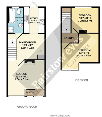
Floorplan 1
Price history
398% since 1997
| Event | Date | Price | % change |
|---|---|---|---|
| Sold | 26/04/2013 (13 years ago) | £164,500 | +398.5% |
| Sold | 31/10/1997 (28 years ago) | £33,000 | — |
Source: HM Land Registry Price Paid Data. Crown copyright.
Sold Comparables
Same street and nearby sales within 0.25 miles (last 5 years). Data from Land Registry Price Paid.
| Address | Price | Date | Type |
|---|---|---|---|
| 133 BEAM AVENUE, DAGENHAM, BARKING AND DAGENHAM, GREATER LONDON, RM10 9BP | £425,000 | 15/01/2026 | Terraced |
| 118 THIRD AVENUE, DAGENHAM, BARKING AND DAGENHAM, GREATER LONDON, RM10 9BB | £345,000 | 19/12/2025 | Terraced |
| 188 BEAM AVENUE, DAGENHAM, BARKING AND DAGENHAM, GREATER LONDON, RM10 9BL | £315,000 | 17/12/2025 | Terraced |
| 190 BEAM AVENUE, DAGENHAM, BARKING AND DAGENHAM, GREATER LONDON, RM10 9BL | £335,000 | 05/12/2025 | Terraced |
| 145 BEAM AVENUE, DAGENHAM, BARKING AND DAGENHAM, GREATER LONDON, RM10 9BP | £370,000 | 04/12/2025 | Terraced |
| 78 SECOND AVENUE, DAGENHAM, BARKING AND DAGENHAM, GREATER LONDON, RM10 9DT | £340,000 | 04/12/2025 | Terraced |
| 62 BEAM AVENUE, DAGENHAM, BARKING AND DAGENHAM, GREATER LONDON, RM10 9BJ | £305,000 | 21/11/2025 | Terraced |
| 133A BEAM AVENUE, DAGENHAM, BARKING AND DAGENHAM, GREATER LONDON, RM10 9BP | £400,000 | 31/10/2025 | Terraced |
| 9 SECOND AVENUE, DAGENHAM, BARKING AND DAGENHAM, GREATER LONDON, RM10 9DX | £415,000 | 23/09/2025 | Terraced |
| 225 BEAM AVENUE, DAGENHAM, BARKING AND DAGENHAM, GREATER LONDON, RM10 9BP | £198,000 | 20/08/2025 | Terraced |
| 134 OVAL ROAD NORTH, DAGENHAM, BARKING AND DAGENHAM, GREATER LONDON, RM10 9EP | £375,000 | 25/07/2025 | Terraced |
| 65 OVAL ROAD SOUTH, DAGENHAM, BARKING AND DAGENHAM, GREATER LONDON, RM10 9DP | £370,000 | 28/03/2025 | Terraced |
| 134 BEAM AVENUE, DAGENHAM, BARKING AND DAGENHAM, GREATER LONDON, RM10 9BL | £375,000 | 30/11/2023 | Terraced |
| Same street 242 OVAL ROAD NORTH, DAGENHAM, BARKING AND DAGENHAM, GREATER LONDON, RM10 9EJ | £350,000 | 21/11/2023 | Terraced |
| 110 BEAM AVENUE, DAGENHAM, BARKING AND DAGENHAM, GREATER LONDON, RM10 9BJ | £358,000 | 08/11/2023 | Terraced |
| 80 THIRD AVENUE, DAGENHAM, BARKING AND DAGENHAM, GREATER LONDON, RM10 9BA | £332,000 | 06/10/2023 | Terraced |
| 204 OVAL ROAD NORTH, DAGENHAM, BARKING AND DAGENHAM, GREATER LONDON, RM10 9EH | £371,000 | 02/10/2023 | Terraced |
| 164 OVAL ROAD SOUTH, DAGENHAM, BARKING AND DAGENHAM, GREATER LONDON, RM10 9EB | £375,000 | 29/09/2023 | Terraced |
| 5 THIRD AVENUE, DAGENHAM, BARKING AND DAGENHAM, GREATER LONDON, RM10 9BE | £330,000 | 23/08/2023 | Terraced |
| 85 THIRD AVENUE, DAGENHAM, BARKING AND DAGENHAM, GREATER LONDON, RM10 9BE | £405,000 | 24/07/2023 | Terraced |
| 221 BEAM AVENUE, DAGENHAM, BARKING AND DAGENHAM, GREATER LONDON, RM10 9BP | £287,000 | 30/06/2023 | Terraced |
| Same street 224 OVAL ROAD NORTH, DAGENHAM, BARKING AND DAGENHAM, GREATER LONDON, RM10 9EJ | £360,000 | 06/04/2023 | Terraced |
| Same street 240 OVAL ROAD NORTH, DAGENHAM, BARKING AND DAGENHAM, GREATER LONDON, RM10 9EJ | £370,000 | 20/07/2022 | Terraced |
| Same street 250 OVAL ROAD NORTH, DAGENHAM, BARKING AND DAGENHAM, GREATER LONDON, RM10 9EJ | £400,000 | 25/03/2022 | Terraced |
| Same street 250 OVAL ROAD NORTH, DAGENHAM, BARKING AND DAGENHAM, GREATER LONDON, RM10 9EJ | £295,000 | 14/07/2021 | Terraced |
Street average: £355,000 (5 sales)
Area average: £351,300 (20 sales)
Capital growth trend
Land Registry outcode average: last 12 months vs 5y and 10y ago (from sold prices).
House Price Index (HM Land Registry — official index, not sold-price averages): Barking and Dagenham. Series: Terraced. As of March 2026.
Rental Range
Estimated market rent for Barking and Dagenham. Low = conservative, Realistic = average, Optimistic = best case.
Based on Local Authority from postcode lookup → Barking and Dagenham.
LHA (30th percentile) floor for Outer North East London: £1,247/mo (Apr 2025 – Mar 2026)
Location
Nearby
Nearest stations, universities and amenities (distance from property).
| Type | Name | Distance |
|---|---|---|
| Bus stop | Dagenham Centre Road | 0.2 miles |
| Shop | One Stop | 0.4 miles |
| Shop | Ecobat Battery | 0.5 miles |
| Train station | Dagenham Dock | 0.8 miles |
| Train station | Dagenham East | 1.0 miles |
| Hospital | Neonatal Unit, L1 Z2 | 5.5 miles |
| Hospital | Rainbow Ward | 5.5 miles |
| University | University of Greenwich Avery Hill Campus | 6.8 miles |
| University | Arden University Stratford Campus | 7.5 miles |
Street-level crime
| Category | Count |
|---|---|
| Violence and sexual offences | 88 |
| Anti-social behaviour | 51 |
| Vehicle crime | 41 |
| Criminal damage and arson | 29 |
| Drugs | 24 |
| Other theft | 18 |
| Public order | 13 |
| Burglary | 11 |
| Robbery | 11 |
| Other crime | 8 |
| Shoplifting | 8 |
| Theft from the person | 6 |
| Possession of weapons | 4 |
| Bicycle theft | 3 |
| Total incidents | 315 |
Within 1 mile during Apr 2026. Source: data.police.uk (England & Wales).
Schools nearby
Nearest open schools with Ofsted ratings (England). Closed schools are not shown. Data from Get Information about Schools and Ofsted.
| Name | Type | Distance | Ofsted |
|---|---|---|---|
| Beam Primary School | Primary | 0.1 miles | Good — 20 Jun 2011 |
| Newtons Primary School | Primary | 0.3 miles | Good — 19 Feb 2019 |
| The Leys Primary School | Primary | 0.5 miles | Good — 18 Dec 2013 |
| Dagenham Park CofE School | Secondary | 0.5 miles | Good — 6 Jun 2016 |
| Marsh Green Primary School | Primary | 0.5 miles | Good — 10 Jul 2014 |
Rental Comparables
Loading rental comparables for this postcode. Refresh in a few minutes.
Rent-driven metrics
Based on Area rent estimate.
- This street — Gross yield for this street only (Land Registry sales + rental comparables, same postcode + street).
- Rent ratio — Monthly rent ÷ purchase price (1% rule). 1%+ = strong, 0.8–1% = okay, <0.8% = weak for cashflow.
- Max investor price — Rent ÷ 0.8%; the price at which rent would be 0.8% of price (Stoke-style target).
- Target investor price — Rent ÷ 1%; the price at which rent would be 1% of price (strong cashflow band).
- Gross yield — Annual rent as % of purchase price (no costs).